Location
Latitude: |
35-26-01.9000N (35.433861) |
Longitude: |
119-03-27.6000W (-119.057667) |
Elevation: |
509.6 feet MSL (155 m MSL) |
Magnetic Variation: |
11.9 E (as of April 2024 from WMM2020 model) |
Time Zone: |
UTC -8.0 (Standard Time) UTC -7.0 (Daylight Savings Time) |
From City: |
03 N.M. NW of Bakersfield, California |
Found On: |
Los Angeles Chart |
FAA Region: |
AWP |
Contacts
Manager: |
Publicly owned: |
| RON BREWSTER 3701 WINGS WAY, #300 BAKERSFIELD, CA 93308 661-391-1824 |
COUNTY OF KERN DEPT OF ARPTS, 3701 WINGS WAY, SUITE 300 BAKERSFIELD, CA 93308 661-391-1800 |
Operations
Airport Status: |
Operational |
Facility Use: |
Public |
Type: |
Airport |
Activation Date: |
04/1940 |
Control tower: |
Yes |
Attendance (Months/Days/Hours): |
Months/Days/Hours ALL/ALL/ALL |
Boundary ARTCC: |
ZLA (Los Angeles) |
Responsible ARTCC: |
ZLA (Los Angeles) |
Lighting Schedule: |
SEE RMK |
Segmented Circle Indicator: |
Yes |
Traffic Pattern Altitude (MSL): |
1510 feet (460 m) |
NOTAMs Facility: |
BFL |
NOTAM-D Service: |
Yes |
International Airport of Entry: |
No |
Customs Landing Rights: |
No |
Military Landing Rights: |
Yes |
Civil/Military Joint Use: |
No |
Aircraft Rescue and Firefighting: |
Class I ARFF Index: B Air Carrier Service: Scheduled Certification Date: 05/1973 |
Based Aircraft
| Single Engine: | 108 |
| Multi Engine: | 52 |
| Jet Engine: | 32 |
| GA Helicopters: | 1 |
| Ultralights: | 1 |
Annual Operations (as of 05/31/2023)
| Total Operations: | 92618 | |
| Commercial: | 3472 | 3.7% |
| Air Taxi: | 6055 | 6.5% |
| GA Local: | 32879 | 35.5% |
| GA Itinerant: | 48281 | 52.1% |
| Military Aircraft: | 1931 | 2.1% |
Communications
| CTAF: | 118.100 |
| Unicom: | 122.950 |
| Tower: | BAKERSFIELD 118.1 257.8 Hrs: 0600-2300 |
| Ground: | 121.7 |
| Approach: | BAKERSFIELD 118.8 ;SOUTH 118.9 ;NORTH 270.3 ;NORTH 284.625 ;SOUTH Hrs: 0600-2300 L.A. CENTER ARTCC Hrs: 2300-0600 |
| Departure: | BAKERSFIELD 118.8 ;SOUTH 118.9 ;NORTH 270.3 ;NORTH 284.625 ;SOUTH Hrs: 0600-2300 L.A. CENTER ARTCC Hrs: 2300-0600 |
| ATIS: | 118.6 Hrs: 24 |
| ASOS: | (661-393-3766) |
| EMERG: | 121.5 |
| EMERG: | 243.0 |
- APCH/DEP CTL SVC PRVDD BY LOS ANGELES ARTCC (ZLA) ON FREQS 127.1/317.7 (BAKERSFIELD RCAG) WHEN BAKERSFIELD APCH CTL (BFL) CLSD.
Fixed Based Operators (FBOs) & Fuel
(Click on a business for detail)
Please help us keep this information up to date. This is a FREE SERVICE just like everything else on Airport Guide! If you see that a business needs to be added, modified, or deleted please fill out our Update Form.
To add, modify, or delete a business click here.
Please help us keep this information up to date. This is a FREE SERVICE just like everything else on Airport Guide! If you see that a business needs to be added, modified, or deleted please fill out our Update Form.
Area Code: 661 |
| Business Name | Frequency | Phone | Fuel Grade |
|---|---|---|---|
| Bakersfield Air Charter
Update FBO info |
393-0937 | ||
| Bakersfield Aircraft Interiors
Update FBO info |
393-8149 | ||
| Bakersfield Aviation Services
Update FBO info |
399-6191 | ||
| Inland Flight Training Center
Website Update FBO info |
(661) 399-3778 | ||
| Loyd's Aviation
Update FBO info |
Unicom 122.95 | 393-1334 | 100LL, Jet A |
| Megahertz Avionics
Update FBO info |
393-1818 | ||
| Mercury Air Center
Update FBO info |
Unicom 122.95, Arinc 131.6 | 391-4900 | 100LL, Jet A |
Flight Service Stations
| Primary | Alternate | |
| FSS on Field: | N | |
| FSS Name (ID): | Rancho Murieta(RIU) | |
| Frequency: | ||
| Toll Free Phone: | 1-800-WX-BRIEF |
Instrument Procedures / Charts
FAA Terminal Procedures valid from 0901Z 03/21/24 to 0901Z 04/18/24.
There are various types of charts available for an airport. They are listed in the Page Type column. Here is a legend for those types:
APD - Airport Diagram
DP - Departure Procedure Charts
HOT - Hot Spots
IAP - Instrument Approach Procedure Charts
MIN - Minimums
STAR - Standard Terminal Arrival Charts
| Page Type | Page Name | Volume | Action Since Last Cycle |
|---|---|---|---|
| APD | AIRPORT DIAGRAM | SW-3 | |
| DP | MARIC FOUR | SW-3 | |
| DP | OILDALE ONE | SW-3 | |
| DP | WRING FOUR | SW-3 | |
| IAP | ILS OR LOC RWY 30R | SW-3 | |
| IAP | RNAV (GPS) RWY 12L | SW-3 | |
| IAP | RNAV (GPS) RWY 12R | SW-3 | |
| IAP | RNAV (GPS) RWY 30L | SW-3 | |
| IAP | RNAV (GPS) RWY 30R | SW-3 | |
| IAP | VOR-A | SW-3 | |
| MIN | ALTERNATE MINIMUMS | SW-3 | |
| MIN | TAKEOFF MINIMUMS | SW-3 | |
| STAR | FASTO TWO | SW-3 |
Terminal Procedures are only available for airports in several countries with more being added all the time. If you are looking for a specific country's charts, please send an email to support(at)airportguide.com stating the country name. This will be used to prioritize the implementation.
Navigation Aids (Navaids) near BFL
| Dist (NM) | ID | Morse Code | Name | Type | Freq | True Hdg | Mag Hdg |
|---|---|---|---|---|---|---|---|
| 0.8 | BFL | _ . . . . . _ . . _ . . | Bakersfield | VOT | 111.20 | 135 | 123 |
| 3.6 | EHF | . . . . . . . _ . | Shafter | VORTAC | 115.40 | 327 | 315 |
| 28.8 | TTE | _ _ . | Tule | VOR-DME | 116.25 | 3 | 351 |
| 39.0 | GMN | _ _ . _ _ _ . | Gorman | VORTAC | 116.10 | 165 | 153 |
| 44.4 | COR | _ . _ . _ _ _ . _ . | Salyer Farms | NDB | 205 | 328 | 316 |
| 44.5 | FLW | . . _ . . _ . . . _ _ | Fellows | VOR-DME | 117.50 | 242 | 230 |
| 46.7 | AVE | . _ . . . _ . | Avenal | VOR-DME | 117.10 | 286 | 274 |
| 50.9 | LHS | . _ . . . . . . . . . | Lake Hughes | VORTAC | 114.35 | 152 | 140 |
| 59.7 | VIS | . . . _ . . . . . | Visalia | VOR-DME | 109.40 | 339 | 327 |
| 65.2 | FIM | . . _ . . . _ _ | Fillmore | VORTAC | 112.50 | 172 | 160 |
| 65.6 | RZS | . _ . _ _ . . . . . | San Marcus | VORTAC | 114.90 | 212 | 200 |
| 68.4 | NID | _ . . . _ . . | China Lake | TACAN | 111.60 | 76 | 64 |
| 68.6 | PMD | . _ _ . _ _ _ . . | Palmdale | VORTAC | 114.50 | 134 | 122 |
| 70.2 | NLC | _ . . _ . . _ . _ . | Lemoore | TACAN | 113.30 | 321 | 309 |
| 70.4 | EDW | . _ . . . _ _ | Edwards | VORTAC | 116.40 | 112 | 100 |
| 73.3 | CMA | _ . _ . _ _ . _ | Camarillo | VOR-DME | 115.80 | 181 | 169 |
| 74.3 | GVO | _ _ . . . . _ _ _ _ | Gaviota | VORTAC | 113.80 | 223 | 211 |
| 77.3 | PAI | . _ _ . . _ . . | Pacoima | NDB | 370 | 155 | 143 |
| 77.4 | GLJ | _ _ . . _ . . . _ _ _ | Guadalupe | VOR | 113.05 | 248 | 236 |
| 77.8 | VNY | . . . _ _ . _ . _ _ | Van Nuys | VOR-DME | 113.10 | 158 | 146 |
Nearby Airports with Fuel
Notices to Airmen (NOTAMS)
Remarks
| A110-1 | MIL HELICOPTERS MAKE ALL APCHS TO RY OR PAVED AREAS. MINIMIZE HOVERING & POWER TO AVOID CAUSING BLOWING DUST; WHEELED HELICOPTERS GND TAXI ONLY. FORMATION JOIN-UP AFT DEP ONLY. |
| A110-11 | RY 30R 50:1 TO DSPLD THLD. |
| A110-13 | ARPT OPS NA BLO 1200 RVR WITHOUT SMGCS. ARPT OPS NOT INITIATED BLO 600 RVR OR AUTH BLO 500 RVR. |
| A110-2 | CAP SQUADRON ON ARPT. |
| A110-4 | RIGHT BASE OPNS FOR RY 30R ESTABLISH WINGS LEVEL ON FINAL APCH NO LOWER THAN 300 FT AGL. |
| A110-9 | NOISE SENSITIVE AREAS S & E OF ARPT RECOMMENDED TURBOJET TRNG HRS WKDAY 0800-2200 WKENDS 1200-2200; NO MORE THAN TEN PRACTICE APCHS PER HR. |
| A13 | RON BREWSTER - BREWSTERR@CO.KERN.CA.US |
| A16 | 24 HRS: (661) 391-1800 FAX: (661) 391-1801 |
| A26 | INDEX C ARFF AVAILABLE |
| A81-APT | WHEN ATCT CLSD ACTVT MALSR RWY 30R; PAPI RWY 12L & 30R; HIRL RWY 12L/30R; TWY LGTS - CTAF. RWY 12R/30L CLSD WHEN ATCT CLSD. |
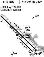
Runways
Runway Summary
| Runways: | 12L/30R 12R/30L |
| Longest Runway: | 12L/30R is 10849 ft (3307 m) long |
| Runways with an Instrument Approach: | 30R |
BFL Airport Runway Details
| Runway 12L/30R | 10849 ft x 150 ft (3307 m x 46 m) | |
| Runway Length Source: | 3RD PARTY SURVEY as of 10/27/2015 | |
| Surface: | Asphalt - Good condition - Saw-cut or plastic grooved | |
| Runway Pavement Class: | 38 /F/B/X/T | |
| Runway Edge Lights: | High Intensity | |
Runway Weight Bearing Capacity (in thousands of pounds) |
||
| Single Wheel Landing Gear: | 96.0 | |
| Dual Wheel Landing Gear: | 155.0 | |
| Dual Tandem Wheel Landing Gear: | 260.0 | |
| Dual Dual Tandem Wheel Landing Gear: | 654.0 | |
Runway 12L |
Runway 30R |
|
Elevation: |
509.5 | 474.2 |
Latitude: |
35-26-46.8273N | 35-25-30.5458N |
Longitude: |
119-04-16.5846W | 119-02-44.3966W |
|
Runway True Alignment: |
135 | 315 |
ILS Type: |
ILS/DME | |
Glide Path Angle: |
3.0 degrees | 3.0 degrees |
Traffic Pattern: |
Left | Right |
Runway Markings Type: |
Precision Instrument | Precision Instrument |
Runway Markings Condition: |
Good | Good |
Visual Glide Slope Indicators: |
4-Light PAPI On Left Side Of Runway | 4-Light PAPI On Left Side Of Runway |
Runway Visual Range (RVR): |
Touchdown, Midfield, Rollout | Touchdown, Midfield, Rollout |
Approach Light System: |
1,400 Foot Medium Intensity Approach Lighting System With Runway Alignment Indicator Lights | |
Touchdown Lights: |
No | Yes |
Centerline Lights: |
No | Yes |
Threshold Crossing Height: |
50 | 51 |
Threshold Elevation: |
484.5 | |
Displaced Threshold: |
3419 | |
Threshold Latitude: |
35-25-54.5873N | |
Threshold Longitude: |
119-03-13.4448W | |
Declared Distances |
||
Take Off Run Avbl. (TORA): |
10848 | 10848 |
Take Off Distance Avbl. (TODA): |
10848 | 10848 |
Actual Stop Dist. Avbl. (ASDA): |
10848 | 10848 |
Landing Dist. Avbl. (LDA): |
10848 | 7429 |
| Runway 12R/30L | 7700 ft x 100 ft (2347 m x 30 m) | |
| Runway Length Source: | 3RD PARTY SURVEY as of 10/27/2015 | |
| Surface: | Asphalt - Good condition - No special surface treatment | |
| Runway Pavement Class: | 14 /F/B/X/U | |
| Runway Edge Lights: | Medium Intensity | |
Runway Weight Bearing Capacity (in thousands of pounds) |
||
| Single Wheel Landing Gear: | 18.0 | |
Runway 12R |
Runway 30L |
|
Elevation: |
486.0 | 463.0 |
Latitude: |
35-26-19.4800N | 35-25-25.3300N |
Longitude: |
119-03-56.2600W | 119-02-50.8400W |
|
Runway True Alignment: |
135 | 315 |
Glide Path Angle: |
3.0 degrees | 3.0 degrees |
Traffic Pattern: |
Right | Left |
Runway Markings Type: |
Basic | Basic |
Runway Markings Condition: |
Good | Good |
Object at End: |
TREE | |
Object Height: |
45 | |
Distance from End: |
2150 | |
Visual Glide Slope Indicators: |
4-Light PAPI On Left Side Of Runway | 4-Light PAPI On Left Side Of Runway |
REIL: |
Yes | Yes |
Touchdown Lights: |
No | No |
Centerline Lights: |
No | No |
Threshold Crossing Height: |
25 | 25 |
Threshold Elevation: |
467.7 | |
Displaced Threshold: |
1499 | |
Threshold Latitude: |
35-25-35.8700N | |
Threshold Longitude: |
119-03-03.5700W | |
Declared Distances |
||
Take Off Run Avbl. (TORA): |
7703 | 7703 |
Take Off Distance Avbl. (TODA): |
7703 | 7703 |
Actual Stop Dist. Avbl. (ASDA): |
7703 | 7703 |
Landing Dist. Avbl. (LDA): |
7703 | 6203 |
Services
Airframe Repair: |
Minor |
Powerplant Repair: |
Minor |
Fuel Available: |
100LL, Jet A |
Landing Fees: |
No |
Parking: |
Hangars and tiedowns available |
Maps & Diagrams
BFL Sectional
Flight Planning
at skyvector.com
at skyvector.com