Location
Latitude: |
45-05-07.1510N (45.08532) |
Longitude: |
070-12-58.7610W (-70.216323) |
Elevation: |
880.0 feet MSL (268 m MSL) |
Magnetic Variation: |
15 W (as of April 2024 from WMM2020 model) |
Time Zone: |
UTC -5.0 (Standard Time) UTC -4.0 (Daylight Savings Time) |
From City: |
01 N.M. N of Carrabassett, Maine |
Found On: |
Montreal Chart |
FAA Region: |
ANE |
Contacts
Manager: |
Publicly owned: |
| TOM WALLACE 1001 CARRIAGE RD CARRABASSETT VALLEY, ME 04947 207-350-1415 |
TOWN OF CARRABASSETT 1001 CARRIAGE RD CARRABASSETT VALLEY, ME 04947 207-235-2646 |
Operations
Airport Status: |
Operational |
Facility Use: |
Public |
Type: |
Airport |
Control tower: |
No |
Attendance (Months/Days/Hours): |
Months/Days/Hours Unattended |
Boundary ARTCC: |
ZBW (Boston) |
Responsible ARTCC: |
ZBW (Boston) |
Segmented Circle Indicator: |
Yes |
Traffic Pattern Altitude (MSL): |
1880 feet (573 m) |
NOTAMs Facility: |
BGR |
NOTAM-D Service: |
Yes |
International Airport of Entry: |
No |
Customs Landing Rights: |
No |
Military Landing Rights: |
Yes |
Civil/Military Joint Use: |
No |
Based Aircraft
| Single Engine: | 14 |
Annual Operations (as of 08/09/2022)
| Total Operations: | 6000 | |
| GA Local: | 3500 | 58.3% |
| GA Itinerant: | 2500 | 41.7% |
Communications
| CTAF: | 122.800 |
| Unicom: | 122.800 |
| AWOS-AV: | 120.0 |
- APCH/DEP SVC PRVDD BY BOSTON ARTCC ON FREQS 120.25/346.4 (BANGOR RCAG).
Fixed Based Operators (FBOs) & Fuel
(Click on a business for detail)
Please help us keep this information up to date. This is a FREE SERVICE just like everything else on Airport Guide! If you see that a business needs to be added, modified, or deleted please fill out our Update Form.
To add, modify, or delete a business click here.
Please help us keep this information up to date. This is a FREE SERVICE just like everything else on Airport Guide! If you see that a business needs to be added, modified, or deleted please fill out our Update Form.
Area Code: 207 |
| Business Name | Frequency | Phone | Fuel Grade |
|---|
Flight Service Stations
| Primary | Alternate | |
| FSS on Field: | N | |
| FSS Name (ID): | Bangor(BGR) | |
| Frequency: | ||
| Toll Free Phone: | 1-800-WX-BRIEF |
Instrument Procedures / Charts
FAA Terminal Procedures valid from 0901Z 03/21/24 to 0901Z 04/18/24.
There are various types of charts available for an airport. They are listed in the Page Type column. Here is a legend for those types:
APD - Airport Diagram
DP - Departure Procedure Charts
HOT - Hot Spots
IAP - Instrument Approach Procedure Charts
MIN - Minimums
STAR - Standard Terminal Arrival Charts
| Page Type | Page Name | Volume | Action Since Last Cycle |
|---|---|---|---|
| IAP | RNAV (GPS)-A | NE-1 | |
| MIN | TAKEOFF MINIMUMS | NE-1 |
Terminal Procedures are only available for airports in several countries with more being added all the time. If you are looking for a specific country's charts, please send an email to support(at)airportguide.com stating the country name. This will be used to prioritize the implementation.
Navigation Aids (Navaids) near B21
| Dist (NM) | ID | Morse Code | Name | Type | Freq | True Hdg | Mag Hdg |
|---|---|---|---|---|---|---|---|
| 24.4 | RQM | . _ . _ _ . _ _ _ | Rangeley | NDB | 221 | 248 | 263 |
| 42.7 | RL | . _ . . _ . . | Bracy | NDB | 399 | 151 | 166 |
| 43.2 | AU | . _ . . _ | Dunns | NDB | 366 | 159 | 174 |
| 43.2 | BUP | _ . . . . . _ . _ _ . | Burnham | NDB | 348 | 122 | 137 |
| 49.3 | AUG | . _ . . _ _ _ . | Augusta | VOR-DME | 114.95 | 158 | 173 |
| 49.4 | BML | _ . . . _ _ . _ . . | Berlin | DME | 116.55 | 237 | 252 |
| 56.9 | VLV | . . . _ . _ . . . . . _ | Beauce | VOR-DME | 117.20 | 332 | 347 |
| 58.8 | BGR | _ . . . _ _ . . _ . | Bangor | VORTAC | 114.80 | 103 | 118 |
| 61.9 | BGR | _ . . . _ _ . . _ . | Bangor | VOT | 111.00 | 105 | 120 |
| 65.4 | BST | _ . . . . . . _ | Belfast | NDB | 278 | 127 | 142 |
| 67.2 | OLD | _ _ _ . _ . . _ . . | Old Town | NDB | 272 | 93 | 108 |
| 67.6 | LE | . _ . . . | Lewie | NDB | 240 | 184 | 199 |
| 67.9 | YSC | _ . _ _ . . . _ . _ . | Sherbrooke | VOR-DME | 113.20 | 282 | 297 |
| 71.8 | HIE | . . . . . . . | Witey | FAN MARKER | 233 | 248 | |
| 72.6 | R1 | Thetford Mines | NDB | 275 | 322 | 337 | |
| 73.2 | RM | . _ . _ _ | Noxks | NDB | 334 | 144 | 159 |
| 73.8 | NHZ | _ . . . . . _ _ . . | Brunswick | TACAN | 115.20 | 170 | 185 |
| 74.9 | SZO | . . . _ _ . . _ _ _ | Sebago | NDB | 227 | 199 | 214 |
| 76.2 | GMA | _ _ . _ _ . _ | Mahn | NDB | 386 | 235 | 250 |
| 77.8 | MLT | _ _ . _ . . _ | Millinocket | VOR-DME | 117.90 | 66 | 81 |
Nearby Airports with Fuel
Notices to Airmen (NOTAMS)
Remarks
| A110-1 | HIGH TRRN 4237 FT MSL NORTH/EAST/WEST OF ARPT. |
| A110-3 | CALL 207-350-1415 TO CK ARPT CONDS. |
| A110-4 | RWY 17/35 SNOWMOBILE/ATV TRAIL 40 FT FM WEST SIDE OF RWY, NORTH OF RAMP. |
| A110-5 | DEER, MOOSE & TURKEY ON & INVOF ARPT. |
| A110-6 | FOR CD CTC BOSTON ARTCC AT 603-879-6859. |
| A14 | ADDNL CTC: TOM WALLACE AT TLWCFII@YAHOO.COM. |
| A42-17 | FADED. |
| A42-35 | FADED. |
| A58-17 | +10 FT ROADWAY 100-200 FT FM THR, 85-125 FT L OF CNTRLN. |
| A75 | BRING OWN TIE DOWN ROPES OR CHAINS. |
| E111 | VFR OPS ONLY. |
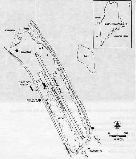
Runways
Runway Summary
| Runways: | 17/35 |
| Longest Runway: | 17/35 is 2797 ft (853 m) long |
| Runways with an Instrument Approach: |
B21 Airport Runway Details
| Runway 17/35 | 2797 ft x 75 ft (853 m x 23 m) | |
| Runway Length Source: | FAA as of 10/09/2020 | |
| Surface: | Asphalt - Good condition - No special surface treatment | |
Runway Weight Bearing Capacity (in thousands of pounds) |
||
| Single Wheel Landing Gear: | 12.0 | |
Runway 17 |
Runway 35 |
|
Elevation: |
880.0 | 856.9 |
Latitude: |
45-05-19.0452N | 45-04-55.2568N |
Longitude: |
070-13-08.6624W | 070-12-48.8605W |
|
Runway True Alignment: |
149 | 329 |
Glide Path Angle: |
0.0 degrees | 0.0 degrees |
Traffic Pattern: |
Left | Left |
Runway Markings Type: |
Basic | Basic |
Runway Markings Condition: |
Poor | Poor |
Object at End: |
ROAD | BLDG |
Object Height: |
10 | 53 |
Distance from End: |
200 | 316 |
Object Centerline Offset: |
85 ft. left of centerline | 160 ft. right of centerline |
Threshold Elevation: |
857.9 | |
Displaced Threshold: |
89 | |
Threshold Latitude: |
45-04-56.0131N | |
Threshold Longitude: |
070-12-49.4900W |
Services
Airframe Repair: |
Major |
Powerplant Repair: |
Major |
Fuel Available: |
100LL |
Landing Fees: |
Yes |
Parking: |
Tiedowns available |
Maps & Diagrams
B21 Sectional
Flight Planning
at skyvector.com
at skyvector.com