Location
Latitude: |
45-26-48.4730N (45.446798) |
Longitude: |
098-25-20.7870W (-98.422441) |
Elevation: |
1301.9 feet MSL (397 m MSL) |
Magnetic Variation: |
3.9 E (as of April 2024 from WMM2020 model) |
Time Zone: |
UTC -6.0 (Standard Time) UTC -5.0 (Daylight Savings Time) |
From City: |
02 N.M. E of Aberdeen, South Dakota |
Found On: |
Twin Cities Chart |
FAA Region: |
AGL |
Contacts
Manager: |
Publicly owned: |
| RICH KROKEL 4740 6TH AVENUE SE ABERDEEN, SD 57401-4215 605-626-7020 |
CITY OF ABERDEEN 123 S LINCOLN ST ABERDEEN, SD 57401-1420 605-626-7020 |
Operations
Airport Status: |
Operational |
Facility Use: |
Public |
Type: |
Airport |
Activation Date: |
12/1937 |
Control tower: |
No |
Attendance (Months/Days/Hours): |
Months/Days/Hours ALL/MON-FRI/0330-2400L |
Boundary ARTCC: |
ZMP (Minneapolis) |
Responsible ARTCC: |
ZMP (Minneapolis) |
Lighting Schedule: |
SEE RMK |
Segmented Circle Indicator: |
Yes |
Traffic Pattern Altitude (MSL): |
2302 feet (702 m) |
NOTAMs Facility: |
ABR |
NOTAM-D Service: |
Yes |
International Airport of Entry: |
No |
Customs Landing Rights: |
No |
Military Landing Rights: |
Yes |
Civil/Military Joint Use: |
No |
Aircraft Rescue and Firefighting: |
Class I ARFF Index: A Air Carrier Service: Scheduled Certification Date: 05/1973 |
Based Aircraft
| Single Engine: | 42 |
| Multi Engine: | 16 |
| Jet Engine: | 7 |
| GA Helicopters: | 1 |
Annual Operations (as of 12/31/2022)
| Total Operations: | 39746 | |
| Commercial: | 1486 | 3.7% |
| Air Taxi: | 5000 | 12.6% |
| GA Local: | 7200 | 18.1% |
| GA Itinerant: | 26000 | 65.4% |
| Military Aircraft: | 60 | 0.2% |
Communications
| CTAF: | 122.700 |
| Unicom: | 122.700 |
| ASOS: | 125.875 (605-229-4512) |
- APCH/DEP SVC PRVDD BY MINNEAPOLIS ARTCC ON FREQS 120.6/371.9 (ABERDEEN RCAG).
Fixed Based Operators (FBOs) & Fuel
(Click on a business for detail)
Please help us keep this information up to date. This is a FREE SERVICE just like everything else on Airport Guide! If you see that a business needs to be added, modified, or deleted please fill out our Update Form.
To add, modify, or delete a business click here.
Please help us keep this information up to date. This is a FREE SERVICE just like everything else on Airport Guide! If you see that a business needs to be added, modified, or deleted please fill out our Update Form.
Area Code: 605 |
| Business Name | Frequency | Phone | Fuel Grade |
|---|---|---|---|
| Aberdeen Flying Service
Update FBO info |
Unicom 123.3 | 225-1384 | 100LL, Jet A |
| Quest Aviation
Update FBO info |
Unicom 122.95 | 225-8008 | 100LL, Jet A, MOGAS |
Flight Service Stations
| Primary | Alternate | |
| FSS on Field: | N | |
| FSS Name (ID): | Huron(HON) | |
| Frequency: | ||
| Toll Free Phone: | 1-800-WX-BRIEF |
Instrument Procedures / Charts
FAA Terminal Procedures valid from 0901Z 03/21/24 to 0901Z 04/18/24.
There are various types of charts available for an airport. They are listed in the Page Type column. Here is a legend for those types:
APD - Airport Diagram
DP - Departure Procedure Charts
HOT - Hot Spots
IAP - Instrument Approach Procedure Charts
MIN - Minimums
STAR - Standard Terminal Arrival Charts
| Page Type | Page Name | Volume | Action Since Last Cycle |
|---|---|---|---|
| APD | AIRPORT DIAGRAM | NC-1 | |
| IAP | ILS OR LOC RWY 31 | NC-1 | |
| IAP | RNAV (GPS) RWY 13 | NC-1 | |
| IAP | RNAV (GPS) RWY 17 | NC-1 | |
| IAP | RNAV (GPS) RWY 31 | NC-1 | |
| IAP | RNAV (GPS) RWY 35 | NC-1 | |
| IAP | VOR RWY 13 | NC-1 | |
| IAP | VOR RWY 31 | NC-1 | |
| MIN | ALTERNATE MINIMUMS | NC-1 | |
| MIN | TAKEOFF MINIMUMS | NC-1 |
Terminal Procedures are only available for airports in several countries with more being added all the time. If you are looking for a specific country's charts, please send an email to support(at)airportguide.com stating the country name. This will be used to prioritize the implementation.
Navigation Aids (Navaids) near ABR
| Dist (NM) | ID | Morse Code | Name | Type | Freq | True Hdg | Mag Hdg |
|---|---|---|---|---|---|---|---|
| 2.9 | ABR | . _ _ . . . . _ . | Aberdeen | VOR-DME | 113.00 | 127 | 123 |
| 5.4 | AB | . _ _ . . . | Reney | NDB | 203 | 132 | 128 |
| 56.9 | GWR | _ _ . . _ _ . _ . | Gwinner | NDB | 278 | 34 | 30 |
| 60.3 | HO | . . . . _ _ _ | Beady | NDB | 302 | 176 | 172 |
| 60.6 | HON | . . . . _ _ _ _ . | Huron | DME | 117.6 | 175 | 171 |
| 61.0 | ATY | . _ _ _ . _ _ | Watertown | TACAN | 116.60 | 116 | 113 |
| 66.3 | AT | . _ _ | Lican | NDB | 215 | 125 | 122 |
| 81.3 | ETH | . _ . . . . | Wheaton | NDB | 326 | 74 | 71 |
| 84.8 | VVV | . . . _ . . . _ . . . _ | Ortonville | NDB | 332 | 95 | 92 |
| 85.2 | JM | . _ _ _ _ _ | Sabon | NDB | 395 | 355 | 351 |
| 89.8 | JMS | . _ _ _ _ _ . . . | Jamestown | VOR-DME | 114.50 | 353 | 349 |
| 89.8 | BWP | _ . . . . _ _ . _ _ . | Breckenridge-Wahpeton | NDB | 233 | 57 | 54 |
| 90.7 | BK | _ . . . _ . _ | Chrlz | NDB | 335 | 135 | 132 |
| 96.8 | BKX | _ . . . _ . _ _ . . _ | Brookings | VOR-DME | 108.80 | 134 | 131 |
| 97.2 | PIR | . _ _ . . . . _ . | Pierre | VORTAC | 113.75 | 230 | 226 |
| 98.8 | DXX | _ . . _ . . _ _ . . _ | Dawson/Madison | NDB | 341 | 105 | 102 |
Nearby Airports with Fuel
Notices to Airmen (NOTAMS)
Remarks
| A110-1 | BIRDS ON & INVOF ARPT. |
| A110-3 | ARPT NOT AVBL FOR INTL ARRIVALS. |
| A110-4 | SURFACE CONDITIONS NOT MONITORED 0000-0330L |
| A110-5 | FOR CD IF UNA TO CTC ON FSS FREQ, CTC MINNEAPOLIS ARTCC AT 651-463-5588. |
| A17 | FOR SVCS AFTER HRS CALL (605) 225-1384/8008 OR (605)725-4774 |
| A26 | PPR FOR UNSKED ACR OPNS WITH MORE THAN 30 PSGR SEATS CALL AMGR 605-626-7020. AFT HRS CALL 605-216-0321. |
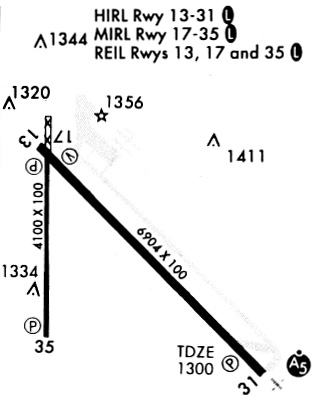
| A81-APT | MIRL RWY 17/35 & HIRL RWY 13/31 PRESET ON LOW INTST SS-2400; TO INCR INTST & ACTVT MALSR RWY 31; REIL RWYS 13, 17, & 35; AND PAPI RWY 13 - CTAF. |
Runways
Runway Summary
| Runways: | 13/31 17/35 |
| Longest Runway: | 13/31 is 6901 ft (2103 m) long |
| Runways with an Instrument Approach: | 31 |
ABR Airport Runway Details
| Runway 13/31 | 6901 ft x 100 ft (2103 m x 30 m) | |
| Runway Length Source: | 3RD PARTY SURVEY as of 07/16/2019 | |
| Surface: | Concrete - Good condition - Saw-cut or plastic grooved | |
| Runway Pavement Class: | 56 /R/B/W/T | |
| Runway Edge Lights: | High Intensity | |
Runway Weight Bearing Capacity (in thousands of pounds) |
||
| Single Wheel Landing Gear: | 120.0 | |
| Dual Wheel Landing Gear: | 195.0 | |
| Dual Tandem Wheel Landing Gear: | 339.0 | |
Runway 13 |
Runway 31 |
|
Elevation: |
1301.9 | 1300.9 |
Latitude: |
45-27-18.8492N | 45-26-30.6268N |
Longitude: |
098-25-40.9344W | 098-24-32.5650W |
|
Runway True Alignment: |
135 | 315 |
ILS Type: |
ILS/DME | |
Glide Path Angle: |
3.0 degrees | 3.0 degrees |
Traffic Pattern: |
Left | Left |
Runway Markings Type: |
Precision Instrument | Precision Instrument |
Runway Markings Condition: |
Good | Good |
Visual Glide Slope Indicators: |
4-Light PAPI On Left Side Of Runway | 4-Light PAPI On Left Side Of Runway |
Approach Light System: |
1,400 Foot Medium Intensity Approach Lighting System With Runway Alignment Indicator Lights | |
REIL: |
Yes | |
Threshold Crossing Height: |
50 | 67 |
Declared Distances |
||
Take Off Run Avbl. (TORA): |
6901 | 6901 |
Take Off Distance Avbl. (TODA): |
6901 | 6901 |
Actual Stop Dist. Avbl. (ASDA): |
6901 | 6901 |
Landing Dist. Avbl. (LDA): |
6901 | 6901 |
| Runway 17/35 | 5500 ft x 100 ft (1676 m x 30 m) | |
| Runway Length Source: | 3RD PARTY SURVEY as of 07/16/2019 | |
| Surface: | Concrete - Good condition - Saw-cut or plastic grooved | |
| Runway Pavement Class: | 25 /F/D/X/T | |
| Runway Edge Lights: | Medium Intensity | |
Runway Weight Bearing Capacity (in thousands of pounds) |
||
| Single Wheel Landing Gear: | 63.0 | |
| Dual Wheel Landing Gear: | 82.0 | |
| Dual Tandem Wheel Landing Gear: | 139.0 | |
Runway 17 |
Runway 35 |
|
Elevation: |
1301.8 | 1300.3 |
Latitude: |
45-27-07.7623N | 45-26-13.4589N |
Longitude: |
098-25-38.4411W | 098-25-38.3626W |
|
Runway True Alignment: |
180 | 360 |
Glide Path Angle: |
3.0 degrees | 3.0 degrees |
Traffic Pattern: |
Left | Left |
Runway Markings Type: |
Precision Instrument | Precision Instrument |
Runway Markings Condition: |
Good | Good |
Visual Glide Slope Indicators: |
4-Light PAPI On Right Side Of Runway | 4-Light PAPI On Left Side Of Runway |
REIL: |
Yes | Yes |
Threshold Crossing Height: |
40 | 40 |
Declared Distances |
||
Take Off Run Avbl. (TORA): |
5500 | 5500 |
Take Off Distance Avbl. (TODA): |
5500 | 5500 |
Actual Stop Dist. Avbl. (ASDA): |
5500 | 5500 |
Landing Dist. Avbl. (LDA): |
5500 | 5500 |
Services
Airframe Repair: |
None |
Powerplant Repair: |
None |
Bottled Oxygen: |
None |
Bulk Oxygen: |
None |
Fuel Available: |
100LL |
Landing Fees: |
No |
Parking: |
Hangars and tiedowns available |
Maps & Diagrams
ABR Sectional
Flight Planning
at skyvector.com
at skyvector.com