Location
Latitude: |
59-33-10.3350N (59.552871) |
Longitude: |
139-30-36.8000W (-139.510222) |
Elevation: |
60.0 feet MSL (18 m MSL) |
Magnetic Variation: |
17.6 E (as of April 2024 from WMM2020 model) |
Time Zone: |
UTC -9.0 (Standard Time) UTC -8.0 (Daylight Savings Time) |
From City: |
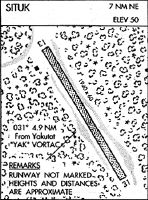
07 N.M. NE of Yakutat, Alaska |
Found On: |
Juneau Chart |
FAA Region: |
AAL |
Contacts
Manager: |
Publicly owned: |
| USFS TONGASS NATIONAL FOREST USFS YAKUTAT RANGER DISTRICT, PO BOX 327 YAKUTAT, AK 99689 907-784-3359 |
USFS TONGASS NATIONAL FOREST USFS YAKUTAT RANGER DISTRICT, PO BOX 327 YAKUTAT, AK 99689 907-784-3359 |
Operations
Airport Status: |
Operational |
Facility Use: |
Public |
Type: |
Airport |
Activation Date: |
05/1965 |
Control tower: |
No |
Attendance (Months/Days/Hours): |
Months/Days/Hours Unattended |
Boundary ARTCC: |
ZAN (Anchorage) |
Responsible ARTCC: |
ZAN (Anchorage) |
Segmented Circle Indicator: |
No |
Traffic Pattern Altitude (MSL): |
1060 feet (323 m) |
NOTAMs Facility: |
YAK |
NOTAM-D Service: |
Yes |
International Airport of Entry: |
No |
Customs Landing Rights: |
No |
Military Landing Rights: |
No |
Civil/Military Joint Use: |
No |
Based Aircraft
Annual Operations (as of 12/31/2019)
| Total Operations: | 130 | |
| Air Taxi: | 80 | 61.5% |
| GA Itinerant: | 50 | 38.5% |
Communications
| CTAF: | 123.600 |
Fixed Based Operators (FBOs) & Fuel
(Click on a business for detail)
Please help us keep this information up to date. This is a FREE SERVICE just like everything else on Airport Guide! If you see that a business needs to be added, modified, or deleted please fill out our Update Form.
To add, modify, or delete a business click here.
Please help us keep this information up to date. This is a FREE SERVICE just like everything else on Airport Guide! If you see that a business needs to be added, modified, or deleted please fill out our Update Form.
Area Code: 907 |
| Business Name | Frequency | Phone | Fuel Grade |
|---|
Flight Service Stations
| Primary | Alternate | |
| FSS on Field: | N | |
| FSS Name (ID): | Juneau(JNU) | |
| Frequency: | ||
| Toll Free Phone: | 1-866-297-2236 |
Instrument Procedures / Charts
Terminal Procedures are only available for airports in several countries with more being added all the time. If you are looking for a specific country's charts, please send an email to support(at)airportguide.com stating the country name. This will be used to prioritize the implementation.
Navigation Aids (Navaids) near A68
| Dist (NM) | ID | Morse Code | Name | Type | Freq | True Hdg | Mag Hdg |
|---|---|---|---|---|---|---|---|
| 4.9 | YAK | _ . _ _ . _ _ . _ | Yakutat | VOR-DME | 113.30 | 239 | 221 |
| 6.7 | OCC | _ _ _ _ . _ . _ . _ . | Ocean Cape | NDB | 385 | 265 | 247 |
| 95.4 | CYT | _ . _ . _ . _ _ _ | Yakataga | NDB | 209 | 290 | 273 |
Nearby Airports with Fuel
| Dist (NM) | Name (Airport IDs) | True Hdg | Mag Hdg | Fuel Grade |
|---|---|---|---|---|
| 5.4 | Yakutat Airport (YAK PAYA YAK) |
236 | 218 | 100, Jet A-1+ |
Notices to Airmen (NOTAMS)
Remarks
| A110-1 | RY SAFETY AREA 75 FT WIDE FULL LENGTH WITH GROUND RISING AND FALLING OVER 12 INCHES. MAINTAIN CNTRLN CONTROL. |
| A110-2 | TREES BTN 50 FT -120 FT BORDER AIRSTRIP SAFETY AREA. |
| A110-3 | NUMEROUS BALD EAGLES FISH AND MATE ABOVE RY. |
| A32-13/31 | 20 FT USABLE, 10 FT EITHER SIDE OF CNTRLN. REMAINDER EITHER SIDE SOFT. |
| A33-13/31 | 7 FT LEVEL ALONG EACH SIDE OF RY CNTRLN. REMAINDER 4 INCHES HIGHER, SOFT & UNEVEN. SOME RUTS OVER 12 INCHES; STANDING WATER AFTER RAIN. |
| A42-13 | RY 13/31 NSTD MKGS: THLD MKD WITH YELLOW PLASTIC PIPES. |
| A75 | DETERIORATED RUBBER TIRES USED AS TIE DOWNS. |
| E111 | ESTABD PRIOR TO 1959. |
Runways
Runway Summary
| Runways: | 13/31 |
| Longest Runway: | 13/31 is 2150 ft (655 m) long |
| Runways with an Instrument Approach: |
A68 Airport Runway Details
| Runway 13/31 | 2150 ft x 10 ft (655 m x 3 m) | |
| Surface: | Turf - Poor condition - No special surface treatment | |
Runway 13 |
Runway 31 |
|
Elevation: |
60.0 | 58.0 |
Latitude: |
59-33-19.8700N | 59-33-00.8000N |
Longitude: |
139-30-45.8700W | 139-30-27.7300W |
Glide Path Angle: |
0.0 degrees | 0.0 degrees |
Traffic Pattern: |
Left | Left |
Runway Markings Type: |
Nonstandard (other than numbers only) | Nonstandard (other than numbers only) |
Object at End: |
TREE | TREE |
Object Height: |
70 | 70 |
Distance from End: |
0 | 0 |
Object Centerline Offset: |
80 ft. left and right of centerline | 120 ft. left and right of centerline |
Services
Airframe Repair: |
None |
Powerplant Repair: |
None |
Bottled Oxygen: |
None |
Bulk Oxygen: |
None |
Fuel Available: |
100, Jet A-1+ |
Landing Fees: |
No |
Maps & Diagrams
A68 Sectional
Flight Planning
at skyvector.com
at skyvector.com