Location
Latitude: |
38-21-31.0520N (38.358626) |
Longitude: |
096-33-16.0260W (-96.554452) |
Elevation: |
1273.0 feet MSL (388 m MSL) |
Magnetic Variation: |
2.6 E (as of April 2024 from WMM2020 model) |
Time Zone: |
UTC -6.0 (Standard Time) UTC -5.0 (Daylight Savings Time) |
From City: |
01 N.M. S of Cottonwood Falls, Kansas |
Found On: |
Kansas City Chart |
FAA Region: |
ACE |
Contacts
Manager: |
Publicly owned: |
| LEE GLANVILLE 220 BROADWAY COTTONWOOD FALLS, KS 66845 620-794-1220 |
CITY OF COTTONWOOD FALLS 220 BROADWAY COTTONWOOD FALLS, KS 66845 620-273-6666 |
Operations
Airport Status: |
Operational |
Facility Use: |
Public |
Type: |
Airport |
Activation Date: |
11/1999 |
Control tower: |
No |
Attendance (Months/Days/Hours): |
Months/Days/Hours Unattended |
Boundary ARTCC: |
ZKC (Kansas City) |
Responsible ARTCC: |
ZKC (Kansas City) |
Lighting Schedule: |
SS-SR |
Segmented Circle Indicator: |
No |
Traffic Pattern Altitude (MSL): |
2273 feet (693 m) |
NOTAMs Facility: |
ICT |
NOTAM-D Service: |
Yes |
Based Aircraft
| Single Engine: | 2 |
| Ultralights: | 1 |
Annual Operations (as of 10/24/2022)
| Total Operations: | 1150 | |
| GA Local: | 600 | 52.2% |
| GA Itinerant: | 500 | 43.5% |
| Military Aircraft: | 50 | 4.3% |
Communications
| CTAF: | 122.900 |
Fixed Based Operators (FBOs) & Fuel
(Click on a business for detail)
Please help us keep this information up to date. This is a FREE SERVICE just like everything else on Airport Guide! If you see that a business needs to be added, modified, or deleted please fill out our Update Form.
To add, modify, or delete a business click here.
Please help us keep this information up to date. This is a FREE SERVICE just like everything else on Airport Guide! If you see that a business needs to be added, modified, or deleted please fill out our Update Form.
Area Code: 620 |
| Business Name | Frequency | Phone | Fuel Grade |
|---|
Flight Service Stations
| Primary | Alternate | |
| FSS on Field: | N | |
| FSS Name (ID): | Wichita(ICT) | |
| Frequency: | ||
| Toll Free Phone: | 1-800-WX-BRIEF |
Instrument Procedures / Charts
Terminal Procedures are only available for airports in several countries with more being added all the time. If you are looking for a specific country's charts, please send an email to support(at)airportguide.com stating the country name. This will be used to prioritize the implementation.
Navigation Aids (Navaids) near 9K0
| Dist (NM) | ID | Morse Code | Name | Type | Freq | True Hdg | Mag Hdg |
|---|---|---|---|---|---|---|---|
| 20.0 | EMP | . _ _ . _ _ . | Emporia | VORTAC | 112.80 | 101 | 99 |
| 23.4 | HRU | . . . . . _ . . . _ | Herington | NDB | 407 | 329 | 326 |
| 36.3 | CA | _ . _ . . _ | Harvs | NDB | 395 | 249 | 246 |
| 38.2 | EWK | . . _ _ _ . _ | Newton | NDB | 281 | 242 | 239 |
| 39.4 | UKL | . . _ _ . _ . _ . . | Boyd | NDB | 245 | 94 | 92 |
| 39.4 | FRI | . . _ . . _ . . . | Fort Riley | VOR | 109.40 | 338 | 335 |
| 41.6 | CVY | _ . _ . . . . _ _ . _ _ | Cavalry | NDB | 314 | 344 | 341 |
| 47.5 | MHK | _ _ . . . . _ . _ | Manhattan | VOR-DME | 110.20 | 353 | 350 |
| 53.3 | MPR | _ _ . _ _ . . _ . | Mc Pherson | NDB | 227 | 269 | 266 |
| 54.7 | FOE | . . _ . _ _ _ . | Forbes | VOT | 111.00 | 49 | 47 |
| 54.7 | SL | . . . . _ . . | Flory | NDB | 344 | 291 | 288 |
| 54.8 | FOE | . . _ . _ _ _ . | Forbes | TACAN | 111.60 | 49 | 47 |
| 55.5 | FO | . . _ . _ _ _ | Riply | NDB | 326 | 55 | 53 |
| 55.6 | IAB | . . . _ _ . . . | Mc Connell | TACAN | 116.50 | 217 | 214 |
| 60.0 | ICT | . . _ . _ . _ | Wichita | VOT | 114.00 | 224 | 221 |
| 60.5 | SLN | . . . . _ . . _ . | Salina | VORTAC | 117.10 | 304 | 301 |
| 61.0 | ICT | . . _ . _ . _ | Wichita | VORTAC | 113.80 | 233 | 230 |
| 61.1 | TO | _ _ _ _ | Biloy | NDB | 521 | 41 | 39 |
| 63.2 | CNU | _ . _ . _ . . . _ | Chanute | VOR-DME | 109.20 | 133 | 131 |
| 63.3 | IC | . . _ . _ . | Piche | NDB | 332 | 222 | 219 |
Nearby Airports with Fuel
Notices to Airmen (NOTAMS)
Remarks
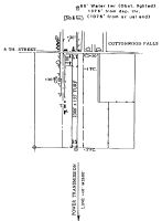
| A110-1 | TOWER 1375 FT FROM AER 17. |
| A110-2 | (A76) NO PHONE AVBL. |
| A110-3 | FOR CD CTC KANSAS CITY ARTCC AT 913-254-8508. |
| A33-17/35 | SOFT & SLICK IN SPOTS WHEN WET. |
| A42-17 | RY 17/35 THLD MARKINGS PAINTED WHITE WITH THLD LGTS. |
| E111 | EXISTED PRIOR TO 1959. |
Runways
Runway Summary
| Runways: | 17/35 |
| Longest Runway: | 17/35 is 2300 ft (701 m) long |
| Runways with an Instrument Approach: |
9K0 Airport Runway Details
| Runway 17/35 | 2300 ft x 155 ft (701 m x 47 m) | |
| Surface: | Turf - Good condition - No special surface treatment | |
| Runway Edge Lights: | Low Intensity | |
Runway 17 |
Runway 35 |
|
Glide Path Angle: |
0.0 degrees | 0.0 degrees |
Traffic Pattern: |
Left | Left |
Object at End: |
POLE | FENCE |
Object Height: |
86 | 3 |
Object Marked/Lighted?: |
Lighted | Marked |
Distance from End: |
1375 | 25 |
Object Centerline Offset: |
54 ft. left of centerline | 0 ft. left and right of centerline |
Services
Airframe Repair: |
Major |
Powerplant Repair: |
Major |
Bottled Oxygen: |
None |
Bulk Oxygen: |
None |
Fuel Available: |
100LL |
Landing Fees: |
No |
Parking: |
Hangars and tiedowns available |
Maps & Diagrams
9K0 Sectional
Flight Planning
at skyvector.com
at skyvector.com