Location
Latitude: |
32-40-53.5450N (32.68154) |
Longitude: |
087-39-43.4490W (-87.662069) |
Elevation: |
175.1 feet MSL (53 m MSL) |
Magnetic Variation: |
3.2 W (as of April 2024 from WMM2020 model) |
Time Zone: |
UTC -6.0 (Standard Time) UTC -5.0 (Daylight Savings Time) |
From City: |
03 N.M. SW of Greensboro, Alabama |
Found On: |
Atlanta Chart |
FAA Region: |
ASO |
Contacts
Manager: |
Publicly owned: |
| CHARLES SEALE PO BOX 437 GREENSBORO, AL 36744 334-624-9871 |
CITY OF GREENSBORO PO DRAWER 77 GREENSBORO, AL 36744 334-624-8119 |
Operations
Airport Status: |
Operational |
Facility Use: |
Public |
Type: |
Airport |
Activation Date: |
04/1964 |
Control tower: |
No |
Attendance (Months/Days/Hours): |
Months/Days/Hours UNATTND |
Boundary ARTCC: |
ZTL (Atlanta) |
Responsible ARTCC: |
ZTL (Atlanta) |
Lighting Schedule: |
SEE RMK |
Segmented Circle Indicator: |
Yes |
Traffic Pattern Altitude (MSL): |
1175 feet (358 m) |
NOTAMs Facility: |
ANB |
NOTAM-D Service: |
Yes |
International Airport of Entry: |
No |
Customs Landing Rights: |
No |
Military Landing Rights: |
No |
Civil/Military Joint Use: |
No |
Based Aircraft
| Single Engine: | 9 |
Annual Operations (as of 10/01/2019)
| Total Operations: | 2088 | |
| GA Local: | 648 | 31.0% |
| GA Itinerant: | 1440 | 69.0% |
Communications
| CTAF: | 123.000 |
| Unicom: | 123.000 |
- APCH/DEP SVC PRVDD BY ATLANTA ARTCC ON FREQS 132.25/263.025 (UNIONTOWN RCAG).
Fixed Based Operators (FBOs) & Fuel
(Click on a business for detail)
Please help us keep this information up to date. This is a FREE SERVICE just like everything else on Airport Guide! If you see that a business needs to be added, modified, or deleted please fill out our Update Form.
To add, modify, or delete a business click here.
Please help us keep this information up to date. This is a FREE SERVICE just like everything else on Airport Guide! If you see that a business needs to be added, modified, or deleted please fill out our Update Form.
Area Code: 334 |
| Business Name | Frequency | Phone | Fuel Grade |
|---|
Flight Service Stations
| Primary | Alternate | |
| FSS on Field: | N | |
| FSS Name (ID): | Anniston(ANB) | |
| Frequency: | ||
| Toll Free Phone: | 1-800-WX-BRIEF |
Instrument Procedures / Charts
FAA Terminal Procedures valid from 0901Z 03/21/24 to 0901Z 04/18/24.
There are various types of charts available for an airport. They are listed in the Page Type column. Here is a legend for those types:
APD - Airport Diagram
DP - Departure Procedure Charts
HOT - Hot Spots
IAP - Instrument Approach Procedure Charts
MIN - Minimums
STAR - Standard Terminal Arrival Charts
| Page Type | Page Name | Volume | Action Since Last Cycle |
|---|---|---|---|
| IAP | RNAV (GPS) RWY 18 | SE-4 | |
| IAP | RNAV (GPS) RWY 36 | SE-4 | |
| MIN | TAKEOFF MINIMUMS | SE-4 |
Terminal Procedures are only available for airports in several countries with more being added all the time. If you are looking for a specific country's charts, please send an email to support(at)airportguide.com stating the country name. This will be used to prioritize the implementation.
Navigation Aids (Navaids) near 7A0
| Dist (NM) | ID | Morse Code | Name | Type | Freq | True Hdg | Mag Hdg |
|---|---|---|---|---|---|---|---|
| 28.6 | TC | _ _ . _ . | Tuske | NDB | 362 | 359 | 362 |
| 35.2 | LDK | . _ . . _ . . _ . _ | Crimson | TACAN | 117.80 | 10 | 13 |
| 39.3 | OKW | _ _ _ _ . _ . _ _ | Brookwood | VORTAC | 111.00 | 31 | 34 |
| 39.5 | JYU | . _ _ _ _ . _ _ . . _ | Junior | VOR-DME | 113.60 | 120 | 123 |
| 44.4 | EWA | . . _ _ . _ | Kewanee | DME | 113.8 | 245 | 248 |
| 44.6 | SE | . . . . | Pollk | NDB | 344 | 123 | 126 |
| 45.1 | NMM | _ . _ _ _ _ | Meridian | TACAN | 111.90 | 262 | 265 |
| 54.0 | GGY | _ _ . _ _ . _ . _ _ | Gragg-Wade | NDB | 338 | 78 | 82 |
| 60.6 | MEI | _ _ . . . | Meridian | VORTAC | 117.00 | 252 | 255 |
| 61.9 | ME | _ _ . | Savoy | NDB | 356 | 245 | 248 |
| 62.4 | MG | _ _ _ _ . | Marra | NDB | 245 | 110 | 114 |
| 64.5 | IGB | . . _ _ . _ . . . | Bigbee | VORTAC | 116.20 | 318 | 321 |
| 64.5 | BH | _ . . . . . . . | Mcden | NDB | 224 | 39 | 43 |
| 67.9 | MXF | _ _ _ . . _ . . _ . | Maxwell | TACAN | 115.00 | 105 | 109 |
| 69.6 | CBM | _ . _ . _ . . . _ _ | Caledonia | VORTAC | 115.20 | 326 | 329 |
| 69.8 | BHM | _ . . . . . . . _ _ | Birmingham Muni | VOT | 110.00 | 40 | 44 |
| 70.6 | VUZ | . . . _ . . _ _ _ . . | Vulcan | VORTAC | 114.40 | 32 | 36 |
| 73.3 | MGM | _ _ _ _ . _ _ | Montgomery | VORTAC | 112.10 | 111 | 115 |
| 73.9 | SCD | . . . _ . _ . _ . . | Sylacauga | NDB | 284 | 66 | 70 |
| 75.0 | MVC | _ _ . . . _ _ . _ . | Monroeville | VORTAC | 116.80 | 167 | 170 |
Nearby Airports with Fuel
Notices to Airmen (NOTAMS)
Remarks
| A110-1 | FOR CD CTC ATLANTA ARTCC AT 770-210-7692. |
| A42-18 | MARKINGS POOR DUE TO FADING. |
| A42-36 | MARKINGS POOR DUE TO FADING. |
| A80 | OTS INDEFLY. |
| A81-APT | ACTVT REIL RWY 18 & 36; MIRL RWY 18/36 - CTAF. |
Runways
Runway Summary
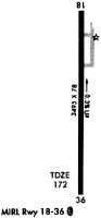
| Runways: | 18/36 |
| Longest Runway: | 18/36 is 3506 ft (1069 m) long |
| Runways with an Instrument Approach: |
7A0 Airport Runway Details
| Runway 18/36 | 3506 ft x 79 ft (1069 m x 24 m) | |
| Runway Length Source: | 3RD PARTY SURVEY as of 09/11/2019 | |
| Surface: | Asphalt - Fair condition - No special surface treatment | |
| Runway Edge Lights: | Medium Intensity | |
Runway Weight Bearing Capacity (in thousands of pounds) |
||
| Single Wheel Landing Gear: | 16.0 | |
Runway 18 |
Runway 36 |
|
Elevation: |
175.1 | 157.6 |
Latitude: |
32-41-10.8910N | 32-40-36.1997N |
Longitude: |
087-39-43.3885W | 087-39-43.5091W |
|
Runway True Alignment: |
181 | 001 |
Glide Path Angle: |
0.0 degrees | 0.0 degrees |
Traffic Pattern: |
Left | Left |
Runway Markings Type: |
Basic | Basic |
Runway Markings Condition: |
Poor | Poor |
Object at End: |
TREES | TREES |
Object Height: |
101 | 69 |
Distance from End: |
2255 | 2181 |
Object Centerline Offset: |
93 ft. right of centerline | 228 ft. left of centerline |
REIL: |
Yes | Yes |
Services
Bottled Oxygen: |
None |
Bulk Oxygen: |
None |
Fuel Available: |
100LL, Jet A+ |
Landing Fees: |
Yes |
Parking: |
Hangars and tiedowns available |
Maps & Diagrams
7A0 Sectional
Flight Planning
at skyvector.com
at skyvector.com