Location
Latitude: |
41-39-15.1770N (41.654216) |
Longitude: |
083-31-52.7600W (-83.531322) |
Elevation: |
650.0 feet MSL (198 m MSL) |
Magnetic Variation: |
7.1 W (as of April 2024 from WMM2020 model) |
Time Zone: |
UTC -5.0 (Standard Time) UTC -4.0 (Daylight Savings Time) |
From City: |
00 N.M. N of Toledo, Ohio |
Found On: |
Detroit Chart |
FAA Region: |
AGL |
Contacts
Manager: |
Publicly owned: |
| TIMOTHY K ODONNELL 11013 AIRPORT HWY, BOX 11 SWANTON, OH 43558-9403 567-703-8631 |
TOLEDO-LUCAS CO PORT AUTH 11013 AIRPORT HWY, BOX 11 SWANTON, OH 43558-9403 419-865-2351 |
Operations
Airport Status: |
Operational |
Facility Use: |
Public |
Type: |
Heliport |
Activation Date: |
04/1982 |
Control tower: |
No |
Attendance (Months/Days/Hours): |
Months/Days/Hours Unattended |
Boundary ARTCC: |
ZOB (Cleveland) |
Responsible ARTCC: |
ZOB (Cleveland) |
Lighting Schedule: |
SEE RMK |
Segmented Circle Indicator: |
No |
Traffic Pattern Altitude (MSL): |
1650 feet (503 m) |
NOTAMs Facility: |
CLE |
NOTAM-D Service: |
Yes |
Based Aircraft
Annual Operations (as of 09/27/2022)
| Total Operations: | 48 | |
| GA Itinerant: | 28 | 58.3% |
| Military Aircraft: | 20 | 41.7% |
Communications
| CTAF: | 123.050 |
| Unicom: | 123.050 |
Fixed Based Operators (FBOs) & Fuel
(Click on a business for detail)
Please help us keep this information up to date. This is a FREE SERVICE just like everything else on Airport Guide! If you see that a business needs to be added, modified, or deleted please fill out our Update Form.
To add, modify, or delete a business click here.
Please help us keep this information up to date. This is a FREE SERVICE just like everything else on Airport Guide! If you see that a business needs to be added, modified, or deleted please fill out our Update Form.
Area Code: 419 |
| Business Name | Frequency | Phone | Fuel Grade |
|---|---|---|---|
| Owens-Illinois, Inc.
Update FBO info |
247-2173 |
Flight Service Stations
| Primary | Alternate | |
| FSS on Field: | ||
| FSS Name (ID): | Cleveland(CLE) | |
| Frequency: | ||
| Toll Free Phone: | 1-800-WX-BRIEF |
Instrument Procedures / Charts
Terminal Procedures are only available for airports in several countries with more being added all the time. If you are looking for a specific country's charts, please send an email to support(at)airportguide.com stating the country name. This will be used to prioritize the implementation.
Navigation Aids (Navaids) near 6T2
| Dist (NM) | ID | Morse Code | Name | Type | Freq | True Hdg | Mag Hdg |
|---|---|---|---|---|---|---|---|
| 12.6 | TOL | _ _ _ _ . _ . . | Toledo | TACAN | 112.50 | 253 | 260 |
| 13.1 | VWV | . . . _ . _ _ . . . _ | Waterville | VOR-DME | 113.10 | 201 | 208 |
| 18.5 | TO | _ _ _ _ | Tophr | NDB | 219 | 251 | 258 |
| 23.9 | CRL | _ . _ . . _ . . _ . . | Carleton | VOR-DME | 115.70 | 7 | 14 |
| 27.1 | USE | . . _ . . . . | Fulton | NDB | 375 | 264 | 271 |
| 27.7 | ADG | . _ _ . . _ _ . | Adrian | NDB | 278 | 298 | 305 |
| 27.8 | TCU | _ _ . _ . . . _ | Tecumseh | NDB | 239 | 325 | 332 |
| 28.5 | FZI | . . _ . _ _ . . . . | Fostoria | NDB | 379 | 167 | 174 |
| 30.8 | PCW | . _ _ . _ . _ . . _ _ | Port Clinton | NDB | 423 | 105 | 112 |
| 31.7 | RYS | . _ . _ . _ _ . . . | Grosse Ile | NDB | 419 | 32 | 39 |
| 34.3 | DXO | _ . . _ . . _ _ _ _ | Detroit | VOR-DME | 113.40 | 12 | 19 |
| 34.8 | YIP | _ . _ _ . . . _ _ . | Willow Run | VOT | 108.85 | 0 | 7 |
| 35.5 | DTW | _ . . _ . _ _ | Detroit Met Wayne | VOT | 109.80 | 12 | 19 |
| 36.5 | TII | _ . . . . | Tiffin | NDB | 269 | 156 | 163 |
| 37.0 | JZJ | . _ _ _ _ _ . . . _ _ _ | Alaina | NDB | 223 | 23 | 30 |
| 38.5 | BNR | _ . . . _ . . _ . | Benton Ridge | NDB | 334 | 189 | 196 |
| 41.4 | ZQG | Laurel | NDB | 398 | 31 | 38 | |
| 41.5 | SKY | . . . _ . _ _ . _ _ | Sandusky | VOR-DME | 109.20 | 108 | 115 |
| 43.1 | FBC | . . _ . _ . . . _ . _ . | Flag City | VORTAC | 108.20 | 193 | 200 |
| 45.3 | SVM | . . . . . . _ _ _ | Salem | VORTAC | 114.30 | 356 | 363 |
Nearby Airports with Fuel
Notices to Airmen (NOTAMS)
Remarks
| A110-1 | APP/DEP CORRIDOR 040-110 DEG MAG, PPR. |
| A110-4 | DOOR TO PAD IS LOCKED, CALL ARPT OPS FOR CODE BFR LDG AT 419-865-2351. |
| A110-5 | FOR CD CTC TOLEDO APCH AT 419-865-1495. |
| A33-H1 | ROOFTOP. |
| A42-H1 | FADED. |
| A42-H1 1 | NOT MKD WITH 'H'. |
| A81-APT | ACTVT PERI LGTS - CTAF. |
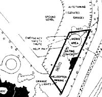
| E111 | PRVDD AREA APROPLY MKD; WIND INDCR MNTND; FINAL APVL UPON FLT EVAL; NO NGT OPS; UNAUZD PERSON RSTRD; FIRE PROTECTION PRVDD. |
Runways
Runway Summary
| Runways: | H1 |
| Longest Runway: | H1 is 50 ft (15 m) long |
| Runways with an Instrument Approach: |
6T2 Airport Runway Details
| Helipad H1 | 50 ft x 50 ft (15 m x 15 m) | |
| Surface: | Concrete - Good condition - No special surface treatment | |
| Runway Edge Lights: | Perimeter lights (for helipads) Intensity | |
Helipad H1 |
||
Elevation: |
650.0 | |
Latitude: |
41-39-15.1770N | |
Longitude: |
083-31-52.7600W | |
Glide Path Angle: |
0.0 degrees | 0.0 degrees |
Runway Markings Type: |
Nonstandard (other than numbers only) | |
Runway Markings Condition: |
Poor |
Services
Fuel Available: |
80, 100LL |
Landing Fees: |
No |
Parking: |
Hangars and tiedowns available |
Maps & Diagrams
6T2 Sectional
Flight Planning
at skyvector.com
at skyvector.com