Location
Latitude: |
40-10-41.3600N (40.178156) |
Longitude: |
086-13-01.4500W (-86.217069) |
Elevation: |
936.0 feet MSL (285 m MSL) |
Magnetic Variation: |
5 W (as of April 2024 from WMM2020 model) |
Time Zone: |
UTC -5.0 (Standard Time) UTC -4.0 (Daylight Savings Time) |
From City: |
03 N.M. N of Sheridan, Indiana |
Found On: |
Chicago Chart |
FAA Region: |
AGL |
Contacts
Manager: |
Privately owned: |
| DARREN CROUSER 27045 JERKWATER ROAD SHERIDAN, IN 46069 317-758-4161 |
CROUSER PROPERTIES LLC 27045 JERKWATER ROAD SHERIDAN, IN 46069 317-501-4521 |
Operations
Airport Status: |
Operational |
Facility Use: |
Public |
Type: |
Airport |
Activation Date: |
06/1947 |
Control tower: |
No |
Attendance (Months/Days/Hours): |
Months/Days/Hours ALL/ALL/0800-1800 |
Boundary ARTCC: |
ZAU (Chicago) |
Responsible ARTCC: |
ZID (Indianapolis) |
Lighting Schedule: |
SEE RMK |
Segmented Circle Indicator: |
No |
Traffic Pattern Altitude (MSL): |
1936 feet (590 m) |
NOTAMs Facility: |
HUF |
NOTAM-D Service: |
Yes |
International Airport of Entry: |
No |
Customs Landing Rights: |
No |
Military Landing Rights: |
No |
Civil/Military Joint Use: |
No |
Based Aircraft
| Single Engine: | 37 |
| Gliders: | 1 |
Annual Operations (as of 12/31/2019)
| Total Operations: | 3916 | |
| Air Taxi: | 117 | 3.0% |
| GA Local: | 1684 | 43.0% |
| GA Itinerant: | 1958 | 50.0% |
| Military Aircraft: | 157 | 4.0% |
Communications
| CTAF: | 123.075 |
| Unicom: | 123.075 |
| Approach: | INDIANAPOLIS 124.65 124.65 |
| Departure: | INDIANAPOLIS 124.65 124.65 |
Fixed Based Operators (FBOs) & Fuel
(Click on a business for detail)
Please help us keep this information up to date. This is a FREE SERVICE just like everything else on Airport Guide! If you see that a business needs to be added, modified, or deleted please fill out our Update Form.
To add, modify, or delete a business click here.
Please help us keep this information up to date. This is a FREE SERVICE just like everything else on Airport Guide! If you see that a business needs to be added, modified, or deleted please fill out our Update Form.
Area Code: 317 |
| Business Name | Frequency | Phone | Fuel Grade |
|---|
Flight Service Stations
| Primary | Alternate | |
| FSS on Field: | N | |
| FSS Name (ID): | Terre Haute(HUF) | |
| Frequency: | ||
| Toll Free Phone: | 1-800-WX-BRIEF |
Instrument Procedures / Charts
FAA Terminal Procedures valid from 0901Z 03/21/24 to 0901Z 04/18/24.
There are various types of charts available for an airport. They are listed in the Page Type column. Here is a legend for those types:
APD - Airport Diagram
DP - Departure Procedure Charts
HOT - Hot Spots
IAP - Instrument Approach Procedure Charts
MIN - Minimums
STAR - Standard Terminal Arrival Charts
| Page Type | Page Name | Volume | Action Since Last Cycle |
|---|---|---|---|
| IAP | RNAV (GPS) RWY 05 | EC-2 | |
| IAP | RNAV (GPS) RWY 23 | EC-2 |
Terminal Procedures are only available for airports in several countries with more being added all the time. If you are looking for a specific country's charts, please send an email to support(at)airportguide.com stating the country name. This will be used to prioritize the implementation.
Navigation Aids (Navaids) near 5I4
| Dist (NM) | ID | Morse Code | Name | Type | Freq | True Hdg | Mag Hdg |
|---|---|---|---|---|---|---|---|
| 16.3 | UMP | . . _ _ _ . _ _ . | Metropolitan | NDB | 338 | 151 | 156 |
| 16.8 | FKR | . . _ . _ . _ . _ . | Frankfort | NDB | 278 | 289 | 294 |
| 22.2 | OKK | _ _ _ _ . _ _ . _ | Kokomo | TACAN | 113.50 | 19 | 24 |
| 22.9 | VHP | . . . _ . . . . . _ _ . | Brickyard | VORTAC | 116.30 | 197 | 202 |
| 27.1 | IND | . . _ . _ . . | Indianapolis Intl | VOT | 109.60 | 188 | 193 |
| 28.2 | GUS | _ _ . . . _ . . . | Grissom | VORTAC | 108.45 | 6 | 11 |
| 31.0 | MZZ | _ _ _ _ . . _ _ . . | Marion | VOR-DME | 108.60 | 52 | 57 |
| 33.1 | AI | . _ . . | Video | NDB | 394 | 101 | 106 |
| 33.2 | HFY | . . . . . . _ . _ . _ _ | Greenwood | NDB | 398 | 169 | 174 |
| 34.2 | CFJ | _ . _ . . . _ . . _ _ _ | Crawfordsville | NDB | 388 | 249 | 254 |
| 37.4 | SHB | . . . . . . . _ . . . | Shelbyville | VOR-DME | 116.15 | 150 | 155 |
| 37.9 | MIE | _ _ . . . | Muncie | VOR-DME | 114.40 | 84 | 89 |
| 38.8 | TVX | _ . . . _ _ . . _ | Greencastle | NDB | 521 | 224 | 229 |
| 40.0 | IWH | . . . _ _ . . . . | Wabash | NDB | 329 | 28 | 33 |
| 41.0 | LA | . _ . . . _ | Earle | NDB | 401 | 291 | 296 |
| 41.1 | JN | . _ _ _ _ . | Balll | NDB | 365 | 89 | 94 |
| 45.0 | UWL | . . _ . _ _ . _ . . | New Castle | NDB | 385 | 113 | 118 |
| 45.1 | BVT | _ . . . . . . _ _ | Boiler | VORTAC | 115.10 | 300 | 305 |
| 53.2 | HHG | . . . . . . . . _ _ . | Huntington | NDB | 417 | 39 | 44 |
| 54.6 | BA | _ . . . . _ | Clifs | NDB | 410 | 160 | 165 |
Nearby Airports with Fuel
Notices to Airmen (NOTAMS)
Remarks
| A11 | DARREN CROUSER, MANAGING MEMBER |
| A110*G | THIS AIRPORT HAS BEEN SURVEYED BY THE NATIONAL GEODETIC SURVEY. |
| A110-7 | DURING WINTER MONTHS CALL AMGR TO VERIFY RY CONDS - 317-758-4161. |
| A110-8 | AFT HRS ASSISTANCE 317-501-4521. |
| A110-9 | FOR CD CTC INDIANAPOLIS APCH AT 317-227-5743. |
| A31-09/27 | HAS A 325 FT STWY WEST END. |
| A40-05/23 | NSTD; RY 23 NSTD THLD LGTS |
| A57-05 | RWY 05 APCH RATIO 22:1 TO DSPLCD THLD. |
| A57-27 | APCH RATIO 21:1 TO DSPLCD THLD. |
| A58-05 | RWY 05 RD 15' FRM END, CROPS 50' FM RWY END. |
| A81-APT | ACTVT NSTD LIRL RY 05/23 - CTAF. |
| A81-BCN | PHONE REQ |
| E111 | EXISTED PRIOR TO 1959. |
Runways
Runway Summary
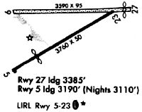
| Runways: | 05/23 09/27 |
| Longest Runway: | 05/23 is 3760 ft (1146 m) long |
| Runways with an Instrument Approach: |
5I4 Airport Runway Details
| Runway 05/23 | 3760 ft x 50 ft (1146 m x 15 m) | |
| Surface: | Asphalt - Fair condition - No special surface treatment | |
| Runway Edge Lights: | Non-standard lighting system Intensity | |
Runway 05 |
Runway 23 |
|
Elevation: |
930.0 | 932.0 |
Latitude: |
40-10-24.3340N | 40-10-47.1990N |
Longitude: |
086-13-23.5820W | 086-12-45.3920W |
|
Runway True Alignment: |
052 | 232 |
Glide Path Angle: |
0.0 degrees | 0.0 degrees |
Traffic Pattern: |
Left | Left |
Runway Markings Type: |
Basic | Basic |
Runway Markings Condition: |
Fair | Fair |
Object at End: |
CROPS | CROPS |
Object Height: |
10 | 10 |
Distance from End: |
201 | 201 |
Object Centerline Offset: |
0 ft. left and right of centerline | 0 ft. left and right of centerline |
Visual Glide Slope Indicators: |
Tri-color VASI On Left Side Of Runway | |
REIL: |
No | No |
Touchdown Lights: |
No | No |
Centerline Lights: |
No | No |
Threshold Elevation: |
930.3 | |
Displaced Threshold: |
650 | |
Threshold Latitude: |
40-10-28.2800N | |
Threshold Longitude: |
086-13-16.9900W |
| Runway 09/27 | 3387 ft x 88 ft (1032 m x 27 m) | |
| Surface: | Asphalt - Fair condition - No special surface treatment | |
Runway 09 |
Runway 27 |
|
Elevation: |
936.0 | 934.0 |
Latitude: |
40-10-47.3000N | 40-10-47.9100N |
Longitude: |
086-13-19.9000W | 086-12-36.3300W |
|
Runway True Alignment: |
088 | 268 |
Glide Path Angle: |
0.0 degrees | 0.0 degrees |
Traffic Pattern: |
Left | Left |
Runway Markings Type: |
None | None |
Object at End: |
BLDG | CROPS |
Object Height: |
18 | 10 |
Distance from End: |
280 | 5 |
Object Centerline Offset: |
0 ft. left and right of centerline | 0 ft. left and right of centerline |
REIL: |
No | No |
Touchdown Lights: |
No | No |
Centerline Lights: |
No | No |
Threshold Elevation: |
934.0 | |
Displaced Threshold: |
250 | |
Threshold Latitude: |
40-10-47.8200N | |
Threshold Longitude: |
086-12-39.5300W |
Services
Airframe Repair: |
Minor |
Powerplant Repair: |
Minor |
Fuel Available: |
100LL, Jet A |
Landing Fees: |
No |
Parking: |
Hangars and tiedowns available |
Maps & Diagrams
5I4 Sectional
Flight Planning
at skyvector.com
at skyvector.com