Location
Latitude: |
32-10-33.9000N (32.176083) |
Longitude: |
094-17-55.7000W (-94.298806) |
Elevation: |
248.0 feet MSL (76 m MSL) |
Magnetic Variation: |
1.2 E (as of April 2024 from WMM2020 model) |
Time Zone: |
UTC -6.0 (Standard Time) UTC -5.0 (Daylight Savings Time) |
From City: |
02 N.M. E of Carthage, Texas |
Found On: |
Memphis Chart |
FAA Region: |
ASW |
Contacts
Manager: |
Publicly owned: |
| ROBERT DUNCAN 1305 HIGHWAY 79 NORTH CARTHAGE, TX 75633 903-693-7856 |
PANOLA CO PANOLA CO. COURTHOUSE CARTHAGE, TX 75633 903-693-0391 |
Operations
Airport Status: |
Operational |
Facility Use: |
Public |
Type: |
Airport |
Activation Date: |
09/1963 |
Control tower: |
No |
Attendance (Months/Days/Hours): |
Months/Days/Hours ALL/MON-FRI/0800-1700 |
Boundary ARTCC: |
ZFW (Fort Worth) |
Responsible ARTCC: |
ZFW (Fort Worth) |
Lighting Schedule: |
SEE RMK |
Segmented Circle Indicator: |
Yes |
Traffic Pattern Altitude (MSL): |
1248 feet (380 m) |
NOTAMs Facility: |
FTW |
NOTAM-D Service: |
Yes |
International Airport of Entry: |
No |
Customs Landing Rights: |
No |
Military Landing Rights: |
Yes |
Civil/Military Joint Use: |
No |
Based Aircraft
| Single Engine: | 20 |
Annual Operations (as of 10/06/2022)
| Total Operations: | 1400 | |
| GA Local: | 400 | 28.6% |
| GA Itinerant: | 1000 | 71.4% |
Communications
| CTAF: | 122.800 |
| Unicom: | 122.800 |
| Approach: | SHREVEPORT 119.9 119.9 |
| Departure: | SHREVEPORT 119.9 119.9 |
| AWOS-3PT: | 121.125 (903-690-0511) |
Fixed Based Operators (FBOs) & Fuel
(Click on a business for detail)
Please help us keep this information up to date. This is a FREE SERVICE just like everything else on Airport Guide! If you see that a business needs to be added, modified, or deleted please fill out our Update Form.
To add, modify, or delete a business click here.
Please help us keep this information up to date. This is a FREE SERVICE just like everything else on Airport Guide! If you see that a business needs to be added, modified, or deleted please fill out our Update Form.
Area Code: 903 |
| Business Name | Frequency | Phone | Fuel Grade |
|---|
Flight Service Stations
| Primary | Alternate | |
| FSS on Field: | N | |
| FSS Name (ID): | Fort Worth(FTW) | |
| Frequency: | ||
| Toll Free Phone: | 1-800-WX-BRIEF |
Instrument Procedures / Charts
FAA Terminal Procedures valid from 0901Z 03/21/24 to 0901Z 04/18/24.
There are various types of charts available for an airport. They are listed in the Page Type column. Here is a legend for those types:
APD - Airport Diagram
DP - Departure Procedure Charts
HOT - Hot Spots
IAP - Instrument Approach Procedure Charts
MIN - Minimums
STAR - Standard Terminal Arrival Charts
| Page Type | Page Name | Volume | Action Since Last Cycle |
|---|---|---|---|
| IAP | RNAV (GPS) RWY 17 | SC-2 | |
| IAP | RNAV (GPS) RWY 35 | SC-2 | |
| MIN | ALTERNATE MINIMUMS | SC-2 |
Terminal Procedures are only available for airports in several countries with more being added all the time. If you are looking for a specific country's charts, please send an email to support(at)airportguide.com stating the country name. This will be used to prioritize the implementation.
Navigation Aids (Navaids) near 4F2
| Dist (NM) | ID | Morse Code | Name | Type | Freq | True Hdg | Mag Hdg |
|---|---|---|---|---|---|---|---|
| 0.3 | RPF | . _ . . _ _ . . . _ . | Carthage | NDB | 332 | 26 | 25 |
| 21.9 | CZJ | _ . _ . _ _ . . . _ _ _ | Amason | NDB | 341 | 160 | 159 |
| 27.2 | GGG | _ _ . _ _ . _ _ . | Gregg County | VORTAC | 112.90 | 302 | 301 |
| 28.0 | MSD | _ _ . . . _ . . | Mansfield | NDB | 414 | 103 | 102 |
| 28.5 | SHV | . . . . . . . . . . _ | Shreveport | VOT | 108.20 | 55 | 54 |
| 28.6 | HNO | . . . . _ . _ _ _ | Henderson | NDB | 371 | 271 | 270 |
| 30.3 | GG | _ _ . _ _ . | Veels | NDB | 410 | 303 | 302 |
| 35.7 | DTN | _ . . _ _ . | Downtown | VOR | 108.60 | 52 | 51 |
| 37.5 | BAD | _ . . . . _ _ . . | Barksdale | TACAN | 115.80 | 58 | 57 |
| 37.8 | GXD | _ _ . _ . . _ _ . . | Nacogdoches | NDB | 391 | 213 | 212 |
| 38.1 | EMG | . _ _ _ _ . | Elm Grove | VORTAC | 111.20 | 69 | 68 |
| 43.5 | EIC | . . . _ . _ . | Belcher | VORTAC | 117.40 | 34 | 33 |
| 43.5 | VIV | . . . _ . . . . . _ | Vivian | NDB | 284 | 19 | 18 |
| 46.7 | OC | _ _ _ _ . _ . | Nados | NDB | 253 | 207 | 206 |
| 48.0 | ABG | . _ _ . . . _ _ . | Ambassador | NDB | 404 | 300 | 299 |
| 50.1 | JSO | . _ _ _ . . . _ _ _ | Cherokee County | NDB | 263 | 248 | 247 |
| 53.0 | MMY | _ _ _ _ _ . _ _ | Many | NDB | 272 | 133 | 132 |
| 56.0 | ATA | . _ _ . _ | Atlanta | NDB | 347 | 5 | 4 |
| 57.1 | TYR | _ _ . _ _ . _ . | Tyler | VOR-DME | 114.20 | 281 | 280 |
| 61.1 | TY | _ _ . _ _ | Indoo | NDB | 320 | 283 | 281 |
Nearby Airports with Fuel
Notices to Airmen (NOTAMS)
Remarks
| A110*G | THIS AIRPORT HAS BEEN SURVEYED BY THE NATIONAL GEODETIC SURVEY. |
| A110-1 | DEER ON & INVOF RWY. |
| A110-3 | FOR CD CTC FORT WORTH ARTCC AT 817-858-7584. |
| A16 | MGR CELL 903-690-2833, SHERIFF OFC 903-693-0333. |
| A70-FUEL-10 | 0LL FUEL 24 HRS SELF-SERVE. |
| A81-APT | MIRL RWY 17/35 PRESET LOW INTST; TO INCR INTST ACTVT - CTAF. PAPI OPR CONSLY. |
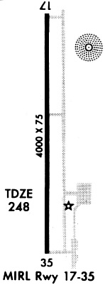
Runways
Runway Summary
| Runways: | 17/35 |
| Longest Runway: | 17/35 is 4000 ft (1219 m) long |
| Runways with an Instrument Approach: |
4F2 Airport Runway Details
| Runway 17/35 | 4000 ft x 75 ft (1219 m x 23 m) | |
| Runway Length Source: | NGS as of 05/21/2008 | |
| Surface: | Asphalt - Fair condition - No special surface treatment | |
| Runway Edge Lights: | Medium Intensity | |
Runway 17 |
Runway 35 |
|
Elevation: |
244.1 | 248.0 |
Latitude: |
32-10-53.6551N | 32-10-14.1000N |
Longitude: |
094-17-56.6228W | 094-17-54.8304W |
|
Runway True Alignment: |
178 | 358 |
Glide Path Angle: |
3.0 degrees | 4.0 degrees |
Traffic Pattern: |
Left | Left |
Runway Markings Type: |
Nonprecision Instrument | Nonprecision Instrument |
Runway Markings Condition: |
Fair | Fair |
Object at End: |
TREES | TREES |
Object Height: |
104 | 80 |
Distance from End: |
3205 | 1900 |
Object Centerline Offset: |
0 ft. left and right of centerline | 100 ft. right of centerline |
Visual Glide Slope Indicators: |
4-Light PAPI On Left Side Of Runway | 4-Light PAPI On Left Side Of Runway |
Services
Bottled Oxygen: |
None |
Bulk Oxygen: |
None |
Fuel Available: |
100LL, Jet A |
Landing Fees: |
No |
Parking: |
Hangars and tiedowns available |
Other Services: |
Parachute rental |
Maps & Diagrams
4F2 Sectional
Flight Planning
at skyvector.com
at skyvector.com