Location
Latitude: |
30-21-26.9680N (30.357491) |
Longitude: |
097-59-40.0840W (-97.994468) |
Elevation: |
909.4 feet MSL (277 m MSL) |
Magnetic Variation: |
3.4 E (as of April 2024 from WMM2020 model) |
Time Zone: |
UTC -6.0 (Standard Time) UTC -5.0 (Daylight Savings Time) |
From City: |
02 N.M. SW of Lakeway, Texas |
Found On: |
San Antonio Chart |
FAA Region: |
ASW |
Contacts
Manager: |
Privately owned: |
| AIRPARK BOARD 115 FLYING SCOT LAKEWAY, TX 78734 512-261-4385 |
LAKEWAY AIRPARK INC 115 FLYING SCOT LAKEWAY, TX 78734 512-261-4385 |
Operations
Airport Status: |
Operational |
Facility Use: |
Public |
Type: |
Airport |
Activation Date: |
01/1963 |
Control tower: |
No |
Attendance (Months/Days/Hours): |
Months/Days/Hours Unattended |
Boundary ARTCC: |
ZHU (Houston) |
Responsible ARTCC: |
ZHU (Houston) |
Segmented Circle Indicator: |
No |
Traffic Pattern Altitude (MSL): |
1909 feet (582 m) |
NOTAMs Facility: |
SJT |
NOTAM-D Service: |
Yes |
International Airport of Entry: |
No |
Customs Landing Rights: |
No |
Military Landing Rights: |
No |
Civil/Military Joint Use: |
No |
Based Aircraft
| Single Engine: | 55 |
| Multi Engine: | 3 |
Annual Operations (as of 06/07/2023)
| Total Operations: | 9000 | |
| GA Local: | 6000 | 66.7% |
| GA Itinerant: | 3000 | 33.3% |
Communications
| CTAF: | 123.000 |
| Unicom: | 123.000 |
| Approach: | AUSTIN |
| Departure: | AUSTIN |
Fixed Based Operators (FBOs) & Fuel
(Click on a business for detail)
Please help us keep this information up to date. This is a FREE SERVICE just like everything else on Airport Guide! If you see that a business needs to be added, modified, or deleted please fill out our Update Form.
To add, modify, or delete a business click here.
Please help us keep this information up to date. This is a FREE SERVICE just like everything else on Airport Guide! If you see that a business needs to be added, modified, or deleted please fill out our Update Form.
| Business Name | Frequency | Phone | Fuel Grade |
|---|
Flight Service Stations
| Primary | Alternate | |
| FSS on Field: | N | |
| FSS Name (ID): | San Angelo(SJT) | |
| Frequency: | ||
| Toll Free Phone: | 1-800-WX-BRIEF |
Instrument Procedures / Charts
FAA Terminal Procedures valid from 0901Z 03/21/24 to 0901Z 04/18/24.
There are various types of charts available for an airport. They are listed in the Page Type column. Here is a legend for those types:
APD - Airport Diagram
DP - Departure Procedure Charts
HOT - Hot Spots
IAP - Instrument Approach Procedure Charts
MIN - Minimums
STAR - Standard Terminal Arrival Charts
| Page Type | Page Name | Volume | Action Since Last Cycle |
|---|---|---|---|
| DP | AEROZ TWO (RNAV) | SC-3 | |
| DP | BNDIA THREE (RNAV) | SC-3 | |
| DP | ELOEL THREE (RNAV) | SC-3 | |
| DP | ILEXY FOUR (RNAV) | SC-3 | |
| DP | MUCKY THREE (RNAV) | SC-3 | |
| DP | SAYBR THREE (RNAV) | SC-3 | |
| IAP | RNAV (GPS) RWY 16 | SC-3 | |
| MIN | TAKEOFF MINIMUMS | SC-3 | |
| STAR | BITER NINE | SC-3 | |
| STAR | BLEWE FIVE | SC-3 | |
| STAR | GABOO ONE (RNAV) | SC-3 | |
| STAR | KALLA FOUR | SC-3 | |
| STAR | POTRR TWO (RNAV) | SC-3 |
Terminal Procedures are only available for airports in several countries with more being added all the time. If you are looking for a specific country's charts, please send an email to support(at)airportguide.com stating the country name. This will be used to prioritize the implementation.
Navigation Aids (Navaids) near 3R9
| Dist (NM) | ID | Morse Code | Name | Type | Freq | True Hdg | Mag Hdg |
|---|---|---|---|---|---|---|---|
| 23.0 | BS | _ . . . . . . | Creed | NDB | 255 | 134 | 131 |
| 24.0 | RU | . _ . . . _ | Garys | NDB | 272 | 174 | 171 |
| 24.1 | CWK | _ . _ . . _ _ _ . _ | Centex | VORTAC | 112.80 | 86 | 83 |
| 25.5 | GUO | _ _ . . . _ _ _ _ | Georgetown | NDB | 332 | 39 | 36 |
| 26.1 | BMQ | _ . . . _ _ _ _ . _ | Burnet | NDB | 341 | 331 | 328 |
| 37.9 | STV | . . . _ . . . _ | Stonewall | VORTAC | 113.80 | 256 | 252 |
| 41.6 | GRK | _ _ . . _ . _ . _ | Gray | VOR-DME | 111.80 | 12 | 9 |
| 42.6 | IL | . . . _ . . | Iresh | NDB | 278 | 20 | 17 |
| 48.6 | HLR | . . . . . _ . . . _ . | Hood | NDB | 347 | 17 | 14 |
| 48.7 | LLO | . _ . . . _ . . _ _ _ | Llano | VORTAC | 108.20 | 302 | 298 |
| 49.0 | GR | _ _ . . _ . | Starn | NDB | 323 | 6 | 3 |
| 49.2 | SAT | . . . . _ _ | San Antonio | VORTAC | 116.80 | 209 | 206 |
| 50.3 | AGJ | . _ _ _ . . _ _ _ | Gooch Springs | VORTAC | 112.50 | 351 | 348 |
| 51.2 | DHK | _ . . . . . . _ . _ | Randolph | TACAN | 109.90 | 196 | 193 |
| 52.5 | RND | . _ . _ . _ . . | Randolph | VORTAC | 112.30 | 196 | 193 |
| 54.0 | AN | . _ _ . | Alamo | NDB | 368 | 213 | 209 |
| 55.3 | SAT | . . . . _ _ | San Antonio | VOT | 110.40 | 206 | 203 |
| 58.9 | TPL | _ . _ _ . . _ . . | Temple | DME | 110.4 | 29 | 26 |
| 65.5 | KSY | _ . _ . . . _ . _ _ | Kelly | TACAN | 112.00 | 207 | 203 |
| 68.5 | CSI | _ . _ . . . . . . | Center Point | VORTAC | 117.50 | 247 | 243 |
Nearby Airports with Fuel
Notices to Airmen (NOTAMS)
Remarks
| A110-1 | NO TGLS. NO LOW PASSES |
| A110-10 | MNTN RWY HDG TIL 1 MI & 400 FT AGL (1300 FT MSL) FOR NOISE ABATEMENT. |
| A110-11 | BLDGS, TREES & PARKED ACFT NEAR RWY. |
| A110-12 | 2-WAY RADIO COM RQRD ON CTAF. |
| A110-15 | 3 FT NON-FRANGIBLE SIGNS 10 FT FM RWY EDGE AT DSPLCD THR, BOTH SIDES. |
| A110-16 | FOR CD CTC AUSTIN APCH AT 512-369-7865. |
| A110-17 | NO COML OPNS PER CITY ORDINANCE. |
| A110-18 | RWY 34, 30 FT MKD PWR LINES ACRS APCH 155 FT DSTC. |
| A110-19 | RWY 34, 30 FT MKD ELEC TMTN LINES CRS THRU APCH 200 FT DSTC. |
| A110-2 | NO NGT OPNS PER CITY ORDINANCE. |
| A110-20 | ARPT WX SR-SS CLICK MIKE 5X ON CTAF. |
| A110-5 | DEER ON & INVOF ARPT. |
| A110-6 | NUMEROUS OBJECTS IN PRIM SFC. |
| A110-8 | ARPT OPNS LTD TO ACFT WITH MAX GWT OF 12500 LBS OR LESS BY CITY ORDINANCE.. |
| A110-9 | ULTRALIGHT AND GLIDER OPNS PROHIBITED. |
| A17 | ARPT CLSD SS-SR. |
| A24 | LNDG FEE FOR TURBINES & JETS. OVNGT TIEDOWN FEE. |
| A33-16/34 | RWY RISES FM S TO N 32 FT. ACFT NOT VISIBLE AT OPPOSITE END. |
| A57-16 | APCH RATIO 0:1 TO DSPLCD THR OVR 40 FT TREE, 0 FT DSTC, 150 FT L. |
| A57-34 | APCH SLOPE 0:1 TO DSPLCD THR OVR 27 FT BLDG 166 FT R & 42 FT TREES 208 FT L 0 FT DSTC, |
| A58-16 | 3 FT BANK 70 FT R OF CNTRLN 0-199 FT DSTC. |
| A58-34 | 34 FT TREES 75--200 FT DSTC ACRS APCH. |
| A70-FUEL-10 | 0LL FUEL SELF-SVC. |
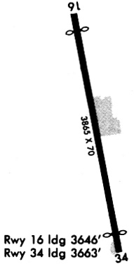
Runways
Runway Summary
| Runways: | 16/34 |
| Longest Runway: | 16/34 is 3930 ft (1198 m) long |
| Runways with an Instrument Approach: |
3R9 Airport Runway Details
| Runway 16/34 | 3930 ft x 70 ft (1198 m x 21 m) | |
| Runway Length Source: | STATE as of 10/27/2003 | |
| Surface: | Asphalt - Fair condition - No special surface treatment | |
Runway Weight Bearing Capacity (in thousands of pounds) |
||
| Single Wheel Landing Gear: | 9.0 | |
Runway 16 |
Runway 34 |
|
Elevation: |
882.4 | 909.3 |
Latitude: |
30-21-46.0451N | 30-21-07.8900N |
Longitude: |
097-59-44.4491W | 097-59-35.7200W |
|
Runway True Alignment: |
169 | 349 |
Glide Path Angle: |
0.0 degrees | 0.0 degrees |
Traffic Pattern: |
Left | Left |
Runway Markings Type: |
Basic | Basic |
Runway Markings Condition: |
Good | Good |
Object at End: |
TREE | TREES |
Object Height: |
30 | 34 |
Distance from End: |
205 | 201 |
Object Centerline Offset: |
0 ft. left and right of centerline | 0 ft. left and right of centerline |
Threshold Elevation: |
883.5 | 909.3 |
Displaced Threshold: |
782 | 624 |
Threshold Latitude: |
30-21-38.4600N | 30-21-13.9500N |
Threshold Longitude: |
097-59-42.7100W | 097-59-37.1000W |
Services
Bulk Oxygen: |
None |
Fuel Available: |
100LL, Jet A |
Landing Fees: |
No |
Parking: |
Tiedowns available |
Maps & Diagrams
3R9 Sectional
Flight Planning
at skyvector.com
at skyvector.com