Location
Latitude: |
34-01-39.4790N (34.027633) |
Longitude: |
100-16-55.2090W (-100.282003) |
Elevation: |
1859.5 feet MSL (567 m MSL) |
Magnetic Variation: |
4.7 E (as of April 2024 from WMM2020 model) |
Time Zone: |
UTC -6.0 (Standard Time) UTC -5.0 (Daylight Savings Time) |
From City: |
01 N.M. E of Paducah, Texas |
Found On: |
Dallas-Ft Worth Chart |
FAA Region: |
ASW |
Contacts
Manager: |
Publicly owned: |
| KARL HOLLOWAY 815 9TH STREET, PO BOX 729 PADUCAH, TX 79248 (806) 492-3613 |
CITY OF PADUCAH & COTTLE CO 815 9TH STREET, PO BOX 759 PADUCAH, TX 79248 (806) 492-3613 |
Operations
Airport Status: |
Operational |
Facility Use: |
Public |
Type: |
Airport |
Control tower: |
No |
Attendance (Months/Days/Hours): |
Months/Days/Hours Unattended |
Boundary ARTCC: |
ZFW (Fort Worth) |
Responsible ARTCC: |
ZFW (Fort Worth) |
Lighting Schedule: |
SEE RMK |
Segmented Circle Indicator: |
Yes |
Traffic Pattern Altitude (MSL): |
2860 feet (872 m) |
NOTAMs Facility: |
FTW |
NOTAM-D Service: |
Yes |
International Airport of Entry: |
No |
Customs Landing Rights: |
No |
Military Landing Rights: |
No |
Civil/Military Joint Use: |
No |
Based Aircraft
| Single Engine: | 4 |
Annual Operations (as of 11/17/2023)
| Total Operations: | 1200 | |
| GA Local: | 800 | 66.7% |
| GA Itinerant: | 400 | 33.3% |
Communications
| CTAF: | 122.900 |
- APCH/DEP CTL SVC PRVDD BY FORT WORTH ARTCC (ZFW) ON FREQS 133.5/350.35 (PADUCAH RCAG).
Fixed Based Operators (FBOs) & Fuel
(Click on a business for detail)
Please help us keep this information up to date. This is a FREE SERVICE just like everything else on Airport Guide! If you see that a business needs to be added, modified, or deleted please fill out our Update Form.
To add, modify, or delete a business click here.
Please help us keep this information up to date. This is a FREE SERVICE just like everything else on Airport Guide! If you see that a business needs to be added, modified, or deleted please fill out our Update Form.
Area Code: 806 |
| Business Name | Frequency | Phone | Fuel Grade |
|---|
Flight Service Stations
| Primary | Alternate | |
| FSS on Field: | N | |
| FSS Name (ID): | Fort Worth(FTW) | |
| Frequency: | ||
| Toll Free Phone: | 1-800-WX-BRIEF |
Instrument Procedures / Charts
FAA Terminal Procedures valid from 0901Z 03/21/24 to 0901Z 04/18/24.
There are various types of charts available for an airport. They are listed in the Page Type column. Here is a legend for those types:
APD - Airport Diagram
DP - Departure Procedure Charts
HOT - Hot Spots
IAP - Instrument Approach Procedure Charts
MIN - Minimums
STAR - Standard Terminal Arrival Charts
| Page Type | Page Name | Volume | Action Since Last Cycle |
|---|---|---|---|
| IAP | RNAV (GPS) RWY 36 | SC-2 | |
| MIN | TAKEOFF MINIMUMS | SC-2 |
Terminal Procedures are only available for airports in several countries with more being added all the time. If you are looking for a specific country's charts, please send an email to support(at)airportguide.com stating the country name. This will be used to prioritize the implementation.
Navigation Aids (Navaids) near 3F6
| Dist (NM) | ID | Morse Code | Name | Type | Freq | True Hdg | Mag Hdg |
|---|---|---|---|---|---|---|---|
| 15.2 | GTH | _ _ . _ . . . . | Guthrie | DME | 114.5 | 190 | 185 |
| 20.5 | CDS | _ . _ . _ . . . . . | Childress | VORTAC | 117.00 | 359 | 354 |
| 53.5 | CZX | _ . _ . _ _ . . _ . . _ | Crosbyton | NDB | 332 | 243 | 238 |
| 57.5 | AKL | . _ _ . _ . _ . . | Haskell | NDB | 407 | 150 | 145 |
| 62.9 | LTS | . _ . . _ . . . | Altus | VORTAC | 109.80 | 52 | 48 |
| 75.1 | PVW | . _ _ . . . . _ . _ _ | Plainview | VOR-DME | 112.90 | 273 | 268 |
| 75.1 | LD | . _ . . _ . . | Lubbi | NDB | 272 | 253 | 248 |
| 78.5 | HBR | . . . . _ . . . . _ . | Hobart | VORTAC | 111.80 | 49 | 45 |
| 83.6 | LBB | . _ . . _ . . . _ . . . | Lubbock | VORTAC | 109.20 | 257 | 252 |
| 84.0 | SPS | . . . . _ _ . . . . | Wichita Falls | VORTAC | 112.70 | 91 | 87 |
| 85.2 | SYO | . . . _ . _ _ _ _ _ | Sayre | VORTAC | 115.20 | 21 | 16 |
| 86.3 | SDR | . . . _ . . . _ . | Snyder | NDB | 359 | 202 | 197 |
| 89.3 | SHP | . . . . . . . . _ _ . | Sheppard | TACAN | 110.80 | 91 | 87 |
| 89.9 | BFV | _ . . . . . _ . . . . _ | Burns Flat | VORTAC | 110.00 | 35 | 31 |
| 90.5 | SKB | . . . _ . _ _ . . . | Scotland | NDB | 344 | 98 | 94 |
| 91.2 | ICF | . . _ . _ . . . _ . | Madison | NDB | 296 | 93 | 89 |
| 94.4 | SWW | . . . . _ _ . _ _ | Sweetwater | NDB | 275 | 185 | 180 |
| 95.1 | ABI | . _ _ . . . . . | Abilene | VORTAC | 113.70 | 167 | 162 |
| 96.8 | LAW | . _ . . . _ . _ _ | Lawton | VOR-DME | 116.85 | 72 | 68 |
| 98.9 | DYS | _ . . _ . _ _ . . . | Dyess | TACAN | 133.60 | 167 | 162 |
Nearby Airports with Fuel
Notices to Airmen (NOTAMS)
Remarks
| A110*G | THIS AIRPORT HAS BEEN SURVEYED BY THE NATIONAL GEODETIC SURVEY. |
| A110-1 | RWY 18, 10 FT DROP OFF 60 FT DSTC. |
| A110-2 | FOR CD CTC FORT WORTH ARTCC AT 817-858-7584. |
| A110-3 | RWY 18/36 MARKED AS 17/35. |
| A14 | COUNTY JUDGE. |
| A33-H1 | NOT MAINTAINED. LOOSE GRAVEL AND GRASS ENCROACHMENT ON SURFACE. |
| A52-H1 | 20 FT LGTD WINDSOCK 165 FT NE; 30 FT PLINE 267 FT E; 20 FT BLDG 240 FT SE. |
| A57-H1 | APCH RATIO FM EAST 8:1; APCH RATIO FM WEST CROSSES CNTRLN OF RY 17/35. |
| A58-18 | 4 FT FENCE AT THR 100 FT RIGHT. |
| A58-36 | 5 FT BERM 90 FT L AT THLD; 5 FT FENCE 93 FT WEST OF CENTERLINE AT THLD. |
| A81-APT | MIRL RWY 18/36 PRESET LOW INTST; TO INCR INTST ACTVT - CTAF. |
Runways
Runway Summary
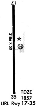
| Runways: | 18/36 H1 |
| Longest Runway: | 18/36 is 3186 ft (971 m) long |
| Runways with an Instrument Approach: |
3F6 Airport Runway Details
| Runway 18/36 | 3186 ft x 50 ft (971 m x 15 m) | |
| Runway Length Source: | NGS as of 07/25/1995 | |
| Surface: | Asphalt - Fair condition - No special surface treatment | |
| Runway Edge Lights: | Medium Intensity | |
Runway Weight Bearing Capacity (in thousands of pounds) |
||
| Single Wheel Landing Gear: | 8.5 | |
Runway 18 |
Runway 36 |
|
Elevation: |
1858.6 | 1850.1 |
Latitude: |
34-01-55.2730N | 34-01-23.7590N |
Longitude: |
100-16-55.2420W | 100-16-55.2060W |
|
Runway True Alignment: |
180 | 360 |
Glide Path Angle: |
0.0 degrees | 0.0 degrees |
Traffic Pattern: |
Left | |
Runway Markings Type: |
Nonprecision Instrument | Nonprecision Instrument |
Runway Markings Condition: |
Good | Good |
Object at End: |
BERM | |
Object Height: |
5 | |
Distance from End: |
200 | |
Object Centerline Offset: |
90 ft. left of centerline |
| Helipad H1 | 25 ft x 25 ft (8 m x 8 m) | |
| Surface: | Asphalt - Fair condition - No special surface treatment | |
Helipad H1 |
||
Elevation: |
1859.5 | |
Latitude: |
34-01-39.6200N | |
Longitude: |
100-16-52.1500W | |
Glide Path Angle: |
0.0 degrees | 0.0 degrees |
Runway Markings Type: |
None | |
Runway Markings Condition: |
Poor | |
Object Centerline Offset: |
90 ft. left of centerline |
Services
Airframe Repair: |
None |
Powerplant Repair: |
None |
Bottled Oxygen: |
None |
Bulk Oxygen: |
None |
Fuel Available: |
100LL, Jet A+ |
Landing Fees: |
No |
Parking: |
Tiedowns available |
Maps & Diagrams
3F6 Sectional
Flight Planning
at skyvector.com
at skyvector.com