Location
Latitude: |
43-08-35.2835N (43.143134) |
Longitude: |
070-46-24.3700W (-70.773436) |
Elevation: |
124.8 feet MSL (38 m MSL) |
Magnetic Variation: |
14.4 W (as of April 2024 from WMM2020 model) |
Time Zone: |
UTC -5.0 (Standard Time) UTC -4.0 (Daylight Savings Time) |
From City: |
02 N.M. SE of Eliot, Maine |
Found On: |
New York Chart |
FAA Region: |
ANE |
Contacts
Manager: |
Privately owned: |
| THOMAS SHAUGHNESSY 380 LAFAYETTE RD, SUITE 11-209 SEABROOK, NH 03874 949-378-8405 |
SHAMROCK AVIATION 380 LAFAYETTE RD, UNIT 11-209 SEABROOK, NH 03874 207-200-5019 |
Operations
Airport Status: |
Operational |
Facility Use: |
Public |
Type: |
Airport |
Activation Date: |
08/1966 |
Control tower: |
No |
Attendance (Months/Days/Hours): |
Months/Days/Hours Unattended |
Boundary ARTCC: |
ZBW (Boston) |
Responsible ARTCC: |
ZBW (Boston) |
Segmented Circle Indicator: |
No |
Traffic Pattern Altitude (MSL): |
1125 feet (343 m) |
NOTAMs Facility: |
BGR |
NOTAM-D Service: |
Yes |
International Airport of Entry: |
No |
Customs Landing Rights: |
No |
Military Landing Rights: |
No |
Civil/Military Joint Use: |
No |
Based Aircraft
| Single Engine: | 12 |
Annual Operations (as of 08/14/2023)
| Total Operations: | 2550 | |
| GA Local: | 2500 | 98.0% |
| GA Itinerant: | 50 | 2.0% |
Communications
| CTAF: | 122.900 |
| Approach: | BOSTON 125.05 125.05 |
| Departure: | BOSTON 125.05 125.05 |
Fixed Based Operators (FBOs) & Fuel
(Click on a business for detail)
Please help us keep this information up to date. This is a FREE SERVICE just like everything else on Airport Guide! If you see that a business needs to be added, modified, or deleted please fill out our Update Form.
To add, modify, or delete a business click here.
Please help us keep this information up to date. This is a FREE SERVICE just like everything else on Airport Guide! If you see that a business needs to be added, modified, or deleted please fill out our Update Form.
Area Code: 207 |
| Business Name | Frequency | Phone | Fuel Grade |
|---|
Flight Service Stations
| Primary | Alternate | |
| FSS on Field: | N | |
| FSS Name (ID): | Bangor(BGR) | |
| Frequency: | ||
| Toll Free Phone: | 1-800-WX-BRIEF |
Instrument Procedures / Charts
FAA Terminal Procedures valid from 0901Z 03/21/24 to 0901Z 04/18/24.
There are various types of charts available for an airport. They are listed in the Page Type column. Here is a legend for those types:
APD - Airport Diagram
DP - Departure Procedure Charts
HOT - Hot Spots
IAP - Instrument Approach Procedure Charts
MIN - Minimums
STAR - Standard Terminal Arrival Charts
| Page Type | Page Name | Volume | Action Since Last Cycle |
|---|---|---|---|
| IAP | RNAV (GPS) RWY 30 | NE-1 | |
| MIN | TAKEOFF MINIMUMS | NE-1 |
Terminal Procedures are only available for airports in several countries with more being added all the time. If you are looking for a specific country's charts, please send an email to support(at)airportguide.com stating the country name. This will be used to prioritize the implementation.
Navigation Aids (Navaids) near 3B4
| Dist (NM) | ID | Morse Code | Name | Type | Freq | True Hdg | Mag Hdg |
|---|---|---|---|---|---|---|---|
| 4.4 | PSM | . _ _ . . . . _ _ | Pease | DME | 116.5 | 216 | 230 |
| 5.2 | ESG | . . . . _ _ . | Rollins | NDB | 260 | 332 | 346 |
| 18.3 | ENE | . _ . . | Kennebunk | VOR-DME | 117.10 | 22 | 36 |
| 28.0 | LWM | . _ . . . _ _ _ _ | Lawrence | DME | 112.5 | 210 | 224 |
| 29.8 | CO | _ . _ . _ _ _ | Epsom | NDB | 216 | 267 | 281 |
| 30.9 | MHT | _ _ . . . . _ | Manchester | VOR-DME | 114.40 | 237 | 251 |
| 32.8 | BVY | _ . . . . . . _ _ . _ _ | Beverly | FAN MARKER | 193 | 207 | |
| 35.3 | LW | . _ . . . _ _ | Haget | NDB | 402 | 212 | 226 |
| 35.4 | CON | _ . _ . _ _ _ _ . | Concord | VOR-DME | 112.90 | 277 | 291 |
| 36.4 | PWM | . _ _ . . _ _ _ _ | Portland | VOT | 111.00 | 33 | 48 |
| 37.1 | MJ | _ _ . _ _ _ | Fitzy | NDB | 209 | 243 | 257 |
| 37.6 | PH | . _ _ . . . . . | Portland Lhb-P | MARINE NDB | 301 | 52 | 67 |
| 38.7 | LCI | . _ . . _ . _ . . . | Laconia | FAN MARKER | 311 | 325 | |
| 40.8 | LC | . _ . . _ . _ . | Blnap | NDB | 328 | 305 | 319 |
| 41.1 | AS | . _ . . . | Chern | NDB | 359 | 242 | 256 |
| 42.3 | LQ | . _ . . _ _ . _ | Lyndy | NDB | 382 | 191 | 205 |
| 44.9 | SKR | . . . _ . _ . _ . | Shaker Hill | NDB | 251 | 203 | 217 |
| 45.7 | SZO | . . . _ _ . . _ _ _ | Sebago | NDB | 227 | 359 | 374 |
| 46.6 | BED | _ . . . . _ . . | Bedford | VOT | 110.00 | 209 | 223 |
| 48.1 | BOS | _ . . . _ _ _ . . . | Boston | VOR-DME | 112.70 | 191 | 205 |
Nearby Airports with Fuel
Notices to Airmen (NOTAMS)
Remarks
| A110-4 | BIRDS & DEER ON & INVOF ARPT. |
| A110-7 | FOR CD CTC BOSTON APCH AT 603-594-5551. |
| A57-30 | 30 FT TREE 5 FT FM DTHR, 180 FT L; 0:1 SLP TO DTHR. |
| A58-12 | 20-25 FT TREES AND BRUSH 0-200 FT FM THR, 115-125 FT L OF CNTRLN; 5-25 FT TREES 5-150 FT FM THR, 15-150 FT R OF CNTRLN AND 15-250 FT L OF CNTRLN. |
| A58-30 | 20 FT TREES 90-135 FT FM THR, 90 FT R OF CNTRLN; 23 FT HOUSE 68 FT FM THR, 118 FT L OF CNTRLN; 35 FT TREES 90 FT FM THR, 100 FT L OF CNTRLN. |
Runways
Runway Summary
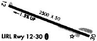
| Runways: | 12/30 |
| Longest Runway: | 12/30 is 2701 ft (823 m) long |
| Runways with an Instrument Approach: |
3B4 Airport Runway Details
| Runway 12/30 | 2701 ft x 50 ft (823 m x 15 m) | |
| Surface: | Asphalt - Excellent condition - No special surface treatment | |
Runway Weight Bearing Capacity (in thousands of pounds) |
||
| Single Wheel Landing Gear: | 8.0 | |
Runway 12 |
Runway 30 |
|
Elevation: |
123.6 | 105.7 |
Latitude: |
43-08-39.8770N | 43-08-30.6900N |
Longitude: |
070-46-41.4600W | 070-46-07.2800W |
|
Runway True Alignment: |
110 | 290 |
Glide Path Angle: |
0.0 degrees | 0.0 degrees |
Traffic Pattern: |
Left | Left |
Runway Markings Type: |
Nonprecision Instrument | Nonprecision Instrument |
Runway Markings Condition: |
Good | Good |
Object at End: |
TREES | TREES |
Object Height: |
25 | 30 |
Distance from End: |
201 | 360 |
Object Centerline Offset: |
60 ft. left of centerline | 130 ft. right of centerline |
Centerline Lights: |
No | No |
Threshold Elevation: |
106.3 | |
Displaced Threshold: |
86 | |
Threshold Latitude: |
43-08-30.9800N | |
Threshold Longitude: |
070-46-08.3700W |
Services
Airframe Repair: |
Major |
Powerplant Repair: |
Major |
Bottled Oxygen: |
High Pressure / Low Pressure |
Bulk Oxygen: |
High Pressure / Low Pressure |
Fuel Available: |
100LL |
Landing Fees: |
No |
Parking: |
Hangars and tiedowns available |
Maps & Diagrams
3B4 Sectional
Flight Planning
at skyvector.com
at skyvector.com