Location
Latitude: |
40-40-23.9000N (40.673306) |
Longitude: |
080-38-29.1000W (-80.641417) |
Elevation: |
1160.5 feet MSL (354 m MSL) |
Magnetic Variation: |
8.9 W (as of April 2024 from WMM2020 model) |
Time Zone: |
UTC -5.0 (Standard Time) UTC -4.0 (Daylight Savings Time) |
From City: |
04 N.M. NW of East Liverpool, Ohio |
Found On: |
Detroit Chart |
FAA Region: |
AGL |
Contacts
Manager: |
Publicly owned: |
| JAMES PUSATERI PO BOX 81 EAST LIVERPOOL, OH 43920-5081 330-397-5769 |
COLUMBIANA CO ARPT AUTH PO BOX 81 EAST LIVERPOOL, OH 43920-5081 330-397-5769 |
Operations
Airport Status: |
Operational |
Facility Use: |
Public |
Type: |
Airport |
Activation Date: |
01/1938 |
Control tower: |
No |
Attendance (Months/Days/Hours): |
Months/Days/Hours Unattended |
Boundary ARTCC: |
ZOB (Cleveland) |
Responsible ARTCC: |
ZOB (Cleveland) |
Lighting Schedule: |
SEE RMK |
Segmented Circle Indicator: |
No |
Traffic Pattern Altitude (MSL): |
2160 feet (658 m) |
NOTAMs Facility: |
CLE |
NOTAM-D Service: |
Yes |
International Airport of Entry: |
No |
Customs Landing Rights: |
No |
Military Landing Rights: |
Yes |
Civil/Military Joint Use: |
No |
Based Aircraft
| Single Engine: | 31 |
| Multi Engine: | 3 |
Annual Operations (as of 06/26/2023)
| Total Operations: | 31100 | |
| Air Taxi: | 50 | 0.2% |
| GA Local: | 26400 | 84.9% |
| GA Itinerant: | 4620 | 14.9% |
| Military Aircraft: | 30 | 0.1% |
Communications
| CTAF: | 123.000 |
| Unicom: | 123.000 |
| Approach: | PITTSBURGH 124.75 124.75 124.75 124.75 |
| Departure: | PITTSBURGH 124.75 124.75 124.75 124.75 |
Fixed Based Operators (FBOs) & Fuel
(Click on a business for detail)
Please help us keep this information up to date. This is a FREE SERVICE just like everything else on Airport Guide! If you see that a business needs to be added, modified, or deleted please fill out our Update Form.
To add, modify, or delete a business click here.
Please help us keep this information up to date. This is a FREE SERVICE just like everything else on Airport Guide! If you see that a business needs to be added, modified, or deleted please fill out our Update Form.
Area Code: 330 |
| Business Name | Frequency | Phone | Fuel Grade |
|---|---|---|---|
| Central Air Flight Training, Inc. Update FBO info |
386-3761 | 80, 100LL |
Flight Service Stations
| Primary | Alternate | |
| FSS on Field: | N | |
| FSS Name (ID): | Cleveland(CLE) | |
| Frequency: | ||
| Toll Free Phone: | 1-800-WX-BRIEF |
Instrument Procedures / Charts
FAA Terminal Procedures valid from 0901Z 03/21/24 to 0901Z 04/18/24.
There are various types of charts available for an airport. They are listed in the Page Type column. Here is a legend for those types:
APD - Airport Diagram
DP - Departure Procedure Charts
HOT - Hot Spots
IAP - Instrument Approach Procedure Charts
MIN - Minimums
STAR - Standard Terminal Arrival Charts
| Page Type | Page Name | Volume | Action Since Last Cycle |
|---|---|---|---|
| IAP | RNAV (GPS) RWY 25 | EC-2 | |
| MIN | TAKEOFF MINIMUMS | EC-2 |
Terminal Procedures are only available for airports in several countries with more being added all the time. If you are looking for a specific country's charts, please send an email to support(at)airportguide.com stating the country name. This will be used to prioritize the implementation.
Navigation Aids (Navaids) near 02G
| Dist (NM) | ID | Morse Code | Name | Type | Freq | True Hdg | Mag Hdg |
|---|---|---|---|---|---|---|---|
| 21.6 | EWC | . . _ _ _ . _ . | Ellwood City | VOR-DME | 115.80 | 64 | 73 |
| 23.2 | MMJ | _ _ _ _ . _ _ _ | Montour | DME | 112 | 118 | 127 |
| 23.3 | UCP | . . _ _ . _ . . _ _ . | Castle | NDB | 272 | 25 | 34 |
| 25.0 | HLG | . . . . . _ . . _ _ . | Wheeling | VOR-DME | 114.25 | 172 | 181 |
| 29.2 | HBD | . . . . _ . . . _ . . | Hubbard | NDB | 408 | 9 | 18 |
| 31.2 | CFX | _ . _ . . . _ . _ . . _ | Cadiz | NDB | 239 | 213 | 222 |
| 31.7 | YN | _ . _ _ _ . | Fetch | NDB | 338 | 3 | 12 |
| 36.2 | BSV | _ . . . . . . . . . _ | Briggs | VOR-DME | 112.40 | 276 | 285 |
| 36.2 | AGC | . _ _ _ . _ . _ . | Allegheny | VOR-DME | 110.00 | 130 | 139 |
| 36.4 | ACO | . _ _ . _ . _ _ _ | Akron | VOR-DME | 114.40 | 315 | 324 |
| 39.2 | CAK | _ . _ . . _ _ . _ | Akron/Canton Regional | VOT | 110.60 | 292 | 301 |
| 39.5 | YNG | _ . _ _ _ . _ _ . | Youngstown | VORTAC | 109.00 | 357 | 366 |
| 40.2 | AIR | . _ . . . _ . | Bellaire | VOR-DME | 117.10 | 191 | 200 |
| 41.4 | AK | . _ _ . _ | Akron | NDB | 362 | 305 | 314 |
| 43.6 | MKP | _ _ _ . _ . _ _ . | Mc Keesport | NDB | 287 | 115 | 124 |
| 46.5 | CTW | _ . _ . _ . _ _ | Newcomerstown | DME | 111.8 | 235 | 244 |
| 55.8 | CXR | _ . _ . _ . . _ . _ . | Chardon | VOR-DME | 112.70 | 335 | 344 |
| 56.6 | MLR | _ _ . _ . . . _ . | Millersburg/Dcmsnd | NDB | 382 | 262 | 271 |
| 58.0 | FKL | . . _ . _ . _ . _ . . | Franklin | VOR | 109.60 | 37 | 46 |
| 60.7 | CIP | _ . _ . . . . _ _ . | Clarion | DME | 112.9 | 61 | 70 |
Nearby Airports with Fuel
Notices to Airmen (NOTAMS)
Remarks
| A110-1 | LGTD OBSTN HI TENSION LINE 1.5 NM NW. |
| A110-5 | DEER, BIRDS, & OTR WILDLIFE ON & INVOF ARPT. |
| A110-6 | FOR CD CTC PITTSBURGH APCH AT 412-472-5591. |
| A70-FUEL-10 | 0LL 100LL AVBL H24 SELF SVC VIA CREDIT CARD. |
| A75 | ROPES NOT PRVDD. |
| A81-APT | ACTVT REIL RWY 07 & 25; PAPI RWY 25; MIRL RWY 07/25 - CTAF. |
Runways
Runway Summary
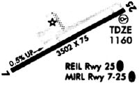
| Runways: | 07/25 |
| Longest Runway: | 07/25 is 3503 ft (1068 m) long |
| Runways with an Instrument Approach: |
02G Airport Runway Details
| Runway 07/25 | 3503 ft x 75 ft (1068 m x 23 m) | |
| Runway Length Source: | 3RD PARTY SURVEY as of 08/21/2014 | |
| Surface: | Asphalt - Good condition - No special surface treatment | |
| Runway Edge Lights: | Medium Intensity | |
Runway Weight Bearing Capacity (in thousands of pounds) |
||
| Single Wheel Landing Gear: | 12.5 | |
Runway 07 |
Runway 25 |
|
Elevation: |
1142.7 | 1160.3 |
Latitude: |
40-40-15.4569N | 40-40-32.4325N |
Longitude: |
080-38-48.9430W | 080-38-09.3280W |
|
Runway True Alignment: |
061 | 241 |
Glide Path Angle: |
0.0 degrees | 3.0 degrees |
Traffic Pattern: |
Left | Left |
Runway Markings Type: |
Nonprecision Instrument | Nonprecision Instrument |
Runway Markings Condition: |
Good | Good |
Object at End: |
TREE | TREES |
Object Height: |
8 | 60 |
Distance from End: |
321 | 1325 |
Object Centerline Offset: |
58 ft. right of centerline | 105 ft. left of centerline |
Visual Glide Slope Indicators: |
4-Light PAPI On Left Side Of Runway | |
REIL: |
Yes | Yes |
Touchdown Lights: |
No | No |
Centerline Lights: |
No | No |
Threshold Crossing Height: |
26 |
Services
Airframe Repair: |
Major |
Powerplant Repair: |
Major |
Bottled Oxygen: |
None |
Bulk Oxygen: |
None |
Fuel Available: |
100LL |
Landing Fees: |
No |
Parking: |
Hangars and tiedowns available |
Maps & Diagrams
02G Sectional
Flight Planning
at skyvector.com
at skyvector.com