Location
Latitude: |
67-30-16.2600N (67.504517) |
Longitude: |
148-28-59.6000W (-148.483222) |
Elevation: |
1920.0 feet MSL (585 m MSL) |
Magnetic Variation: |
15.4 E (as of April 2024 from WMM2020 model) |
Time Zone: |
UTC -9.0 (Standard Time) UTC -8.0 (Daylight Savings Time) |
From City: |
00 N.M. N of Chandalar Lake, Alaska |
Found On: |
Fairbanks Chart |
FAA Region: |
AAL |
Contacts
Manager: |
Publicly owned: |
| JEFF RUSSELL 2301 PEGER RD FAIRBANKS, AK 99709 907-452-2207 |
ALASKA DOT&PF NORTHERN REGION 2301 PEGER RD FAIRBANKS, AK 99709 907-451-2200 |
Operations
Airport Status: |
Operational |
Facility Use: |
Public |
Type: |
Airport |
Activation Date: |
08/1958 |
Control tower: |
No |
Attendance (Months/Days/Hours): |
Months/Days/Hours Unattended |
Boundary ARTCC: |
ZAN (Anchorage) |
Responsible ARTCC: |
ZAN (Anchorage) |
Segmented Circle Indicator: |
Yes |
Traffic Pattern Altitude (MSL): |
2920 feet (890 m) |
NOTAMs Facility: |
WCR |
NOTAM-D Service: |
Yes |
Military Landing Rights: |
Yes |
Based Aircraft
Annual Operations (as of 12/31/2022)
| Total Operations: | 200 | |
| Air Taxi: | 100 | 50.0% |
| GA Local: | 100 | 50.0% |
Communications
| CTAF: | 122.900 |
Fixed Based Operators (FBOs) & Fuel
(Click on a business for detail)
Please help us keep this information up to date. This is a FREE SERVICE just like everything else on Airport Guide! If you see that a business needs to be added, modified, or deleted please fill out our Update Form.
To add, modify, or delete a business click here.
Please help us keep this information up to date. This is a FREE SERVICE just like everything else on Airport Guide! If you see that a business needs to be added, modified, or deleted please fill out our Update Form.
Area Code: 907 |
| Business Name | Frequency | Phone | Fuel Grade |
|---|
Flight Service Stations
| Primary | Alternate | |
| FSS on Field: | ||
| FSS Name (ID): | Fairbanks(FAI) | |
| Frequency: | ||
| Toll Free Phone: | 1-866-248-6516 |
Instrument Procedures / Charts
Terminal Procedures are only available for airports in several countries with more being added all the time. If you are looking for a specific country's charts, please send an email to support(at)airportguide.com stating the country name. This will be used to prioritize the implementation.
Navigation Aids (Navaids) near WCR
| Dist (NM) | ID | Morse Code | Name | Type | Freq | True Hdg | Mag Hdg |
|---|---|---|---|---|---|---|---|
| 0.3 | CQR | _ . _ . _ _ . _ . _ . | Chandalar Lake | NDB | 263 | 111 | 96 |
| 62.8 | GBH | _ _ . _ . . . . . . . | Galbraith Lake | NDB | 417 | 339 | 324 |
| 64.8 | PPC | . _ _ . . _ _ . _ . _ . | Prospect | NDB | 340 | 231 | 216 |
| 79.5 | BTT | _ . . . _ _ | Bettles | VOR-DME | 116.00 | 244 | 229 |
| 80.5 | EAV | . . _ . . . _ | Evansville | NDB | 391 | 244 | 229 |
| 83.0 | AKP | . _ _ . _ . _ _ . | Anaktuvuk Pass | NDB | 348 | 298 | 283 |
| 93.5 | FYU | . . _ . _ . _ _ . . _ | Fort Yukon | VORTAC | 114.40 | 125 | 109 |
| 94.5 | FTO | . . _ . _ _ _ _ | Yukon River | NDB | 242 | 124 | 108 |
Nearby Airports with Fuel
| Dist (NM) | Name (Airport IDs) | True Hdg | Mag Hdg | Fuel Grade |
|---|---|---|---|---|
| 79.2 | Bettles Airport (BTT PABT BTT) |
244 | 230 | 100LL, Jet A-1+ |
| 82.9 | Anaktuvuk Pass Airport (AKP PAKP AKP) |
298 | 284 | Jet A |
Notices to Airmen (NOTAMS)
Remarks
| A110-3 | UNATTENDED. NO WINTER MAINT, SKI EQUIPPED AIRCRAFT ONLY. RWY NOT MAINTAINED AND CONDITION NOT MONITORED, RECOMMEND VISUAL INSPECTION PRIOR TO LANDING |
| A30-03/21 | SLOPES DOWN HILL 4% FROM N TO S. |
| A42-03 | RYS 04 & 22 NSTD MKGS; THLDS MKD WITH REFLECTIVE BOARDS, NO EDGE MKRS. |
Runways
Runway Summary
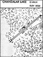
| Runways: | 03/21 |
| Longest Runway: | 03/21 is 3000 ft (914 m) long |
| Runways with an Instrument Approach: |
WCR Airport Runway Details
| Runway 03/21 | 3000 ft x 60 ft (914 m x 18 m) | |
| Runway Length Source: | ADO as of 03/11/2014 | |
| Surface: | Gravel/Dirt - Good condition - No special surface treatment | |
Runway 03 |
Runway 21 |
|
Elevation: |
1920.0 | 1920.0 |
Latitude: |
67-30-08.2900N | 67-30-24.2300N |
Longitude: |
148-29-32.0200W | 148-28-27.1700W |
|
Runway True Alignment: |
057 | 237 |
Glide Path Angle: |
0.0 degrees | 0.0 degrees |
Traffic Pattern: |
Left | Left |
Runway Markings Type: |
Nonstandard (other than numbers only) | Nonstandard (other than numbers only) |
Object at End: |
BRUSH | BRUSH |
Object Height: |
8 | 5 |
Distance from End: |
0 | 0 |
Object Centerline Offset: |
75 ft. left and right of centerline | 60 ft. left and right of centerline |
Services
Fuel Available: |
Jet A |
Landing Fees: |
No |
Maps & Diagrams
WCR Sectional
Flight Planning
at skyvector.com
at skyvector.com