Location
Latitude: |
57-31-24.3300N (57.523425) |
Longitude: |
157-23-45.5800W (-157.395994) |
Elevation: |
43.8 feet MSL (13 m MSL) |
Magnetic Variation: |
11.7 E (as of April 2024 from WMM2020 model) |
Time Zone: |
UTC -9.0 (Standard Time) UTC -8.0 (Daylight Savings Time) |
From City: |
01 N.M. N of Ugashik, Alaska |
Found On: |
Kodiak Chart |
FAA Region: |
AAL |
Contacts
Manager: |
Publicly owned: |
| FLOYD WILSON BOX 65 KING SALMON, AK 99613 907-246-3325 |
ALASKA DOT&PF SOUTHCOAST REGION PO BOX 112500 JUNEA\U, AK 99811-2500 907-465-4512 |
Operations
Airport Status: |
Operational |
Facility Use: |
Public |
Type: |
Airport |
Activation Date: |
01/1983 |
Control tower: |
No |
Attendance (Months/Days/Hours): |
Months/Days/Hours Unattended |
Boundary ARTCC: |
ZAN (Anchorage) |
Responsible ARTCC: |
ZAN (Anchorage) |
Segmented Circle Indicator: |
No |
Traffic Pattern Altitude (MSL): |
1044 feet (318 m) |
NOTAMs Facility: |
ENA |
NOTAM-D Service: |
Yes |
Military Landing Rights: |
Yes |
Based Aircraft
Annual Operations (as of 12/31/2020)
| Total Operations: | 1450 | |
| Air Taxi: | 700 | 48.3% |
| GA Local: | 500 | 34.5% |
| GA Itinerant: | 250 | 17.2% |
Communications
| CTAF: | 122.900 |
Fixed Based Operators (FBOs) & Fuel
(Click on a business for detail)
Please help us keep this information up to date. This is a FREE SERVICE just like everything else on Airport Guide! If you see that a business needs to be added, modified, or deleted please fill out our Update Form.
To add, modify, or delete a business click here.
Please help us keep this information up to date. This is a FREE SERVICE just like everything else on Airport Guide! If you see that a business needs to be added, modified, or deleted please fill out our Update Form.
Area Code: 907 |
| Business Name | Frequency | Phone | Fuel Grade |
|---|
Flight Service Stations
| Primary | Alternate | |
| FSS on Field: | ||
| FSS Name (ID): | Kenai(ENA) | |
| Frequency: | ||
| Toll Free Phone: | 1-866-864-1737 |
Instrument Procedures / Charts
Terminal Procedures are only available for airports in several countries with more being added all the time. If you are looking for a specific country's charts, please send an email to support(at)airportguide.com stating the country name. This will be used to prioritize the implementation.
Navigation Aids (Navaids) near UGS
| Dist (NM) | ID | Morse Code | Name | Type | Freq | True Hdg | Mag Hdg |
|---|---|---|---|---|---|---|---|
| 53.1 | PDN | . _ _ . _ . . _ . | Port Heiden | NDB-DME | 371 | 230 | 219 |
| 74.9 | AKN | . _ _ . _ _ . | King Salmon | VORTAC | 112.80 | 15 | 3 |
| 75.4 | AUB | . _ . . _ _ . . . | Chinook | NDB | 355 | 14 | 2 |
| 95.5 | DLG | _ . . . _ . . _ _ . | Dillingham | VOR-DME | 116.40 | 338 | 327 |
| 95.7 | BTS | _ . . . _ . . . | Wood River | NDB | 429 | 338 | 327 |
Nearby Airports with Fuel
| Dist (NM) | Name (Airport IDs) | True Hdg | Mag Hdg | Fuel Grade |
|---|---|---|---|---|
| 73.1 | King Salmon Airport (AKN PAKN AKN) |
18 | 6 | 100LL, Jet A |
| 97.8 | Dillingham Airport (DLG PADL DLG) |
339 | 328 | 100LL, Jet A |
Notices to Airmen (NOTAMS)
Remarks
| A110-1 | RY CONDITION NOT MONITORED; RECOMMEND VISUAL INSPECTION PRIOR TO LANDING. |
| A110-5 | BRUSH ALONG BOTH SIDES OF RY AND NEAR RY THLDS. |
| A110-7 | BE ALERT: PVT RY APPROXIMATELY 2500 FT SSE OF PUBLIC ARPT 9A8. |
| A33-06/24 | RY SOFT WHEN WET; WATER POND MID-FLD 3 FT X 5 FT X 3 IN DEEP. |
| A42-06 | RYS 06/24 MKD WITH REFLECTIVE ORANGE CONES & THLD PANELS. |
Runways
Runway Summary
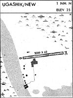
| Runways: | 06/24 |
| Longest Runway: | 06/24 is 3100 ft (945 m) long |
| Runways with an Instrument Approach: |
UGS Airport Runway Details
| Runway 06/24 | 3100 ft x 60 ft (945 m x 18 m) | |
| Runway Length Source: | STATE as of 04/02/2009 | |
| Surface: | Gravel - Good condition - No special surface treatment | |
Runway 06 |
Runway 24 |
|
Elevation: |
25.5 | 43.8 |
Latitude: |
57-31-21.0300N | 57-31-27.6300N |
Longitude: |
157-24-13.3000W | 157-23-17.8600W |
Glide Path Angle: |
0.0 degrees | 0.0 degrees |
Traffic Pattern: |
Right | |
Runway Markings Type: |
Nonstandard (other than numbers only) | Nonstandard (other than numbers only) |
Object at End: |
BRUSH | BRUSH |
Object Height: |
6 | 7 |
Distance from End: |
0 | 0 |
Object Centerline Offset: |
96 ft. left and right of centerline | 65 ft. left and right of centerline |
Services
Airframe Repair: |
Minor |
Powerplant Repair: |
Minor |
Fuel Available: |
100LL, Jet A |
Parking: |
Tiedowns available |
Maps & Diagrams
UGS Sectional
Flight Planning
at skyvector.com
at skyvector.com