Location
Latitude: |
36-09-23.7000N (36.156583) |
Longitude: |
119-19-35.6000W (-119.326556) |
Elevation: |
265.3 feet MSL (81 m MSL) |
Magnetic Variation: |
12.1 E (as of April 2024 from WMM2020 model) |
Time Zone: |
UTC -8.0 (Standard Time) UTC -7.0 (Daylight Savings Time) |
From City: |
03 N.M. SE of Tulare, California |
Found On: |
San Francisco Chart |
FAA Region: |
AWP |
Contacts
Manager: |
Publicly owned: |
| JOSH MCDONNELL 3981 SOUTH K STREET TULARE, CA 93274 559-684-4201 |
CITY OF TULARE 411 EAST KERN AVENUE TULARE, CA 93274 559-685-2300 |
Operations
Airport Status: |
Operational |
Facility Use: |
Public |
Type: |
Airport |
Activation Date: |
07/1940 |
Control tower: |
No |
Attendance (Months/Days/Hours): |
Months/Days/Hours ALL/ALL/0800-DUSK |
Boundary ARTCC: |
ZOA (Oakland) |
Responsible ARTCC: |
ZOA (Oakland) |
Lighting Schedule: |
SEE RMK |
Segmented Circle Indicator: |
Yes |
Traffic Pattern Altitude (MSL): |
1265 feet (386 m) |
NOTAMs Facility: |
RIU |
NOTAM-D Service: |
Yes |
International Airport of Entry: |
No |
Customs Landing Rights: |
No |
Military Landing Rights: |
Yes |
Civil/Military Joint Use: |
No |
Based Aircraft
| Single Engine: | 26 |
| GA Helicopters: | 1 |
Annual Operations (as of 12/29/2020)
| Total Operations: | 25090 | |
| GA Local: | 13090 | 52.2% |
| GA Itinerant: | 12000 | 47.8% |
Communications
| CTAF: | 122.700 |
| Unicom: | 122.700 |
| Approach: | FRESNO 118.5 118.5 |
| Departure: | FRESNO 118.5 118.5 |
| AWOS-3PT: | 120.0 (559-686-2613) |
- COM WITH FRESNO APCH UNAVBL BLO 1000 FT; COM THRU RANCHO MURIETA FSS 1-800-992-7433.
Fixed Based Operators (FBOs) & Fuel
(Click on a business for detail)
Please help us keep this information up to date. This is a FREE SERVICE just like everything else on Airport Guide! If you see that a business needs to be added, modified, or deleted please fill out our Update Form.
To add, modify, or delete a business click here.
Please help us keep this information up to date. This is a FREE SERVICE just like everything else on Airport Guide! If you see that a business needs to be added, modified, or deleted please fill out our Update Form.
Area Code: 209 |
| Business Name | Frequency | Phone | Fuel Grade |
|---|---|---|---|
| Johnston Aircraft Services, Inc.
Update FBO info |
686-2161 | ||
| Valley Air Crafts
Update FBO info |
686-7401 | 100ll, Jet A |
Flight Service Stations
| Primary | Alternate | |
| FSS on Field: | N | |
| FSS Name (ID): | Rancho Murieta(RIU) | |
| Frequency: | ||
| Toll Free Phone: | 1-800-WX-BRIEF |
Instrument Procedures / Charts
FAA Terminal Procedures valid from 0901Z 03/21/24 to 0901Z 04/18/24.
There are various types of charts available for an airport. They are listed in the Page Type column. Here is a legend for those types:
APD - Airport Diagram
DP - Departure Procedure Charts
HOT - Hot Spots
IAP - Instrument Approach Procedure Charts
MIN - Minimums
STAR - Standard Terminal Arrival Charts
| Page Type | Page Name | Volume | Action Since Last Cycle |
|---|---|---|---|
| IAP | RNAV (GPS) RWY 13 | SW-2 | |
| MIN | TAKEOFF MINIMUMS | SW-2 |
Terminal Procedures are only available for airports in several countries with more being added all the time. If you are looking for a specific country's charts, please send an email to support(at)airportguide.com stating the country name. This will be used to prioritize the implementation.
Navigation Aids (Navaids) near TLR
| Dist (NM) | ID | Morse Code | Name | Type | Freq | True Hdg | Mag Hdg |
|---|---|---|---|---|---|---|---|
| 11.3 | COR | _ . _ . _ _ _ . _ . | Salyer Farms | NDB | 205 | 241 | 229 |
| 14.7 | VIS | . . . _ . . . . . | Visalia | VOR-DME | 109.40 | 329 | 317 |
| 20.8 | TTE | _ _ . | Tule | VOR-DME | 116.25 | 134 | 122 |
| 32.9 | NLC | _ . . _ . . _ . _ . | Lemoore | TACAN | 113.30 | 290 | 278 |
| 41.8 | EHF | . . . . . . . _ . | Shafter | VORTAC | 115.40 | 164 | 152 |
| 41.9 | FCH | . . _ . _ . _ . . . . . | Chandler | NDB | 344 | 324 | 312 |
| 44.0 | AVE | . _ . . . _ . | Avenal | VOR-DME | 117.10 | 226 | 214 |
| 46.0 | BFL | _ . . . . . _ . . _ . . | Bakersfield | VOT | 111.20 | 162 | 150 |
| 49.6 | CZQ | _ . _ . _ _ . . _ _ . _ | Clovis | TACAN | 112.90 | 331 | 319 |
| 58.3 | FRA | . . _ . . _ . . _ | Friant | VORTAC | 115.60 | 347 | 335 |
| 64.8 | ROM | . _ . _ _ _ _ _ | Priest | VOR | 110.00 | 269 | 257 |
| 69.0 | FLW | . . _ . . _ . . . _ _ | Fellows | VOR-DME | 117.50 | 202 | 190 |
| 69.6 | PRB | . _ _ . . _ . _ . . . | Paso Robles | VORTAC | 114.30 | 245 | 233 |
| 77.7 | PXN | . _ _ . _ . . _ _ . | Panoche | VORTAC | 112.60 | 295 | 283 |
| 82.1 | HYP | . . . . _ . _ _ . _ _ . | El Nido | VOR-DME | 114.20 | 321 | 309 |
| 84.3 | GMN | _ _ . _ _ _ . | Gorman | VORTAC | 116.10 | 164 | 152 |
| 84.3 | NID | _ . . . _ . . | China Lake | TACAN | 111.60 | 108 | 96 |
| 86.6 | BIH | _ . . . . . . . . . | Bishop | VOR-DME | 109.60 | 31 | 19 |
| 88.4 | MQO | _ _ _ _ . _ _ _ _ | Morro Bay | VORTAC | 112.40 | 232 | 220 |
| 91.1 | HGT | . . . . _ _ . _ | Hunter Liggett | NDB | 209 | 263 | 251 |
Nearby Airports with Fuel
Notices to Airmen (NOTAMS)
Remarks
| A110*G | THIS AIRPORT HAS BEEN SURVEYED BY THE NATIONAL GEODETIC SURVEY. |
| A110-2 | FOR CD CTC FRESNO APCH AT 559-487-5405. |
| A43-13 | UNUSBL BYD 7 DEG R OF CNTRLN. |
| A57-31 | TREES PENETRATE THE APCH 520 FT FROM THE RWY 31 APCH THLD. |
| A81-APT | ACTVT MIRL RWY 13/31 - CTAF. PAPI 13 OPRS CONSLY. |
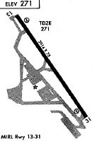
Runways
Runway Summary
| Runways: | 13/31 |
| Longest Runway: | 13/31 is 3901 ft (1189 m) long |
| Runways with an Instrument Approach: |
TLR Airport Runway Details
| Runway 13/31 | 3901 ft x 75 ft (1189 m x 23 m) | |
| Runway Length Source: | NGS as of 12/02/2008 | |
| Surface: | Asphalt - Good condition - No special surface treatment | |
| Runway Edge Lights: | Medium Intensity | |
Runway Weight Bearing Capacity (in thousands of pounds) |
||
| Single Wheel Landing Gear: | 12.5 | |
Runway 13 |
Runway 31 |
|
Elevation: |
265.3 | 262.5 |
Latitude: |
36-09-39.8895N | 36-09-07.5495N |
Longitude: |
119-19-48.6126W | 119-19-22.6724W |
|
Runway True Alignment: |
147 | 327 |
Glide Path Angle: |
3.0 degrees | 3.0 degrees |
Traffic Pattern: |
Left | Left |
Runway Markings Type: |
Nonprecision Instrument | Nonprecision Instrument |
Runway Markings Condition: |
Good | Good |
Object at End: |
ROAD | TREES |
Object Height: |
15 | 40 |
Distance from End: |
500 | 520 |
Object Centerline Offset: |
295 ft. right of centerline | 150 ft. left and right of centerline |
Visual Glide Slope Indicators: |
2-Light PAPI On Left Side Of Runway | 2-Light PAPI On Left Side Of Runway |
REIL: |
No | No |
Touchdown Lights: |
No | No |
Centerline Lights: |
No | No |
Threshold Crossing Height: |
42 | 40 |
Services
Fuel Available: |
100LL |
Landing Fees: |
No |
Parking: |
Tiedowns available |
Maps & Diagrams
TLR Sectional
Flight Planning
at skyvector.com
at skyvector.com