Location
Latitude: |
28-02-18.8407N (28.038567) |
Longitude: |
097-32-33.0045W (-97.542501) |
Elevation: |
47.9 feet MSL (15 m MSL) |
Magnetic Variation: |
3.1 E (as of April 2024 from WMM2020 model) |
Time Zone: |
UTC -6.0 (Standard Time) UTC -5.0 (Daylight Savings Time) |
From City: |
02 N.M. W of Sinton, Texas |
Found On: |
San Antonio Chart |
FAA Region: |
ASW |
Contacts
Manager: |
Publicly owned: |
| GARY LEE DAVIS 3141 FM 3512 ARANSAS PASS, TX 78336 361-226-0112 |
SAN PATRICIO COUNTY SAN PATRICIO COUNTY COURTHOUSE, 400 W SINTON ST SINTON, TX 78387 361-364-9300 |
Operations
Airport Status: |
Operational |
Facility Use: |
Public |
Type: |
Airport |
Activation Date: |
04/1945 |
Control tower: |
No |
Attendance (Months/Days/Hours): |
Months/Days/Hours ALL/ALL/0730-1700 |
Boundary ARTCC: |
ZHU (Houston) |
Responsible ARTCC: |
ZHU (Houston) |
Lighting Schedule: |
SEE RMK |
Segmented Circle Indicator: |
Yes |
Traffic Pattern Altitude (MSL): |
1048 feet (319 m) |
NOTAMs Facility: |
SJT |
NOTAM-D Service: |
Yes |
International Airport of Entry: |
No |
Customs Landing Rights: |
No |
Military Landing Rights: |
No |
Civil/Military Joint Use: |
No |
Based Aircraft
| Single Engine: | 31 |
| Multi Engine: | 4 |
| GA Helicopters: | 1 |
Annual Operations (as of 04/18/2023)
| Total Operations: | 3000 | |
| GA Local: | 1000 | 33.3% |
| GA Itinerant: | 2000 | 66.7% |
Communications
| CTAF: | 122.800 |
| Unicom: | 122.800 |
| Approach: | CORPUS 120.9 120.9 |
| Departure: | CORPUS 120.9 120.9 |
| AWOS-3: | 118.25 (361-364-1844) |
Fixed Based Operators (FBOs) & Fuel
(Click on a business for detail)
Please help us keep this information up to date. This is a FREE SERVICE just like everything else on Airport Guide! If you see that a business needs to be added, modified, or deleted please fill out our Update Form.
To add, modify, or delete a business click here.
Please help us keep this information up to date. This is a FREE SERVICE just like everything else on Airport Guide! If you see that a business needs to be added, modified, or deleted please fill out our Update Form.
Area Code: 512 |
| Business Name | Frequency | Phone | Fuel Grade |
|---|---|---|---|
| Sky Park Aviation
Update FBO info |
Unicom 122.8 | 364-3200 | 100LL, Jet A |
Flight Service Stations
| Primary | Alternate | |
| FSS on Field: | N | |
| FSS Name (ID): | San Angelo(SJT) | |
| Frequency: | ||
| Toll Free Phone: | 1-800-WX-BRIEF |
Instrument Procedures / Charts
FAA Terminal Procedures valid from 0901Z 03/21/24 to 0901Z 04/18/24.
There are various types of charts available for an airport. They are listed in the Page Type column. Here is a legend for those types:
APD - Airport Diagram
DP - Departure Procedure Charts
HOT - Hot Spots
IAP - Instrument Approach Procedure Charts
MIN - Minimums
STAR - Standard Terminal Arrival Charts
| Page Type | Page Name | Volume | Action Since Last Cycle |
|---|---|---|---|
| IAP | RNAV (GPS) RWY 14 | SC-3 | |
| IAP | RNAV (GPS) RWY 32 | SC-3 | |
| IAP | VOR RWY 14 | SC-3 | |
| MIN | ALTERNATE MINIMUMS | SC-3 | |
| MIN | TAKEOFF MINIMUMS | SC-3 |
Terminal Procedures are only available for airports in several countries with more being added all the time. If you are looking for a specific country's charts, please send an email to support(at)airportguide.com stating the country name. This will be used to prioritize the implementation.
Navigation Aids (Navaids) near T69
| Dist (NM) | ID | Morse Code | Name | Type | Freq | True Hdg | Mag Hdg |
|---|---|---|---|---|---|---|---|
| 9.6 | CRP | _ . _ . . _ . . _ _ . | Corpus Christi | VORTAC | 115.50 | 147 | 144 |
| 23.0 | MNO | _ _ _ . _ _ _ | Mellon Ranch | NDB | 375 | 50 | 47 |
| 24.9 | NGP | _ . _ _ . . _ _ . | Truax | TACAN | 114.00 | 148 | 145 |
| 27.9 | NOG | _ . _ _ _ _ _ . | Orange Grove | TACAN | 133.60 | 252 | 249 |
| 31.1 | ALI | . _ . _ . . . . | Alice | VOR | 114.50 | 234 | 231 |
| 35.2 | NQI | _ . _ _ . _ . . | Kingsville | TACAN | 117.80 | 203 | 200 |
| 38.8 | TKB | _ _ . _ _ . . . | Kleberg County | NDB | 347 | 228 | 225 |
| 42.6 | THX | _ . . . . _ . . _ | Three Rivers | VORTAC | 111.40 | 311 | 308 |
| 58.6 | BKS | _ . . . _ . _ . . . | Brooks County | NDB | 353 | 211 | 208 |
| 59.6 | VCT | . . . _ _ . _ . _ | Victoria | VOR-DME | 109.00 | 29 | 26 |
| 75.9 | HBV | . . . . _ . . . . . . _ | Hebbronville | NDB | 266 | 237 | 234 |
| 78.4 | PSX | . _ _ . . . . _ . . _ | Palacios | VORTAC | 117.30 | 55 | 52 |
| 79.3 | OKT | _ _ _ _ . _ _ | Yoakum | NDB | 350 | 15 | 12 |
| 87.1 | COT | _ . _ . _ _ _ _ | Cotulla | VORTAC | 115.80 | 287 | 284 |
| 87.2 | SSF | . . . . . . . . _ . | Stinson | VOR | 108.40 | 327 | 324 |
| 96.0 | SNE | . . . _ . . | Santa Elena | NDB | 260 | 214 | 211 |
| 97.0 | RND | . _ . _ . _ . . | Randolph | VORTAC | 112.30 | 336 | 333 |
| 97.7 | DHK | _ . . . . . . _ . _ | Randolph | TACAN | 109.90 | 337 | 334 |
| 97.9 | KSY | _ . _ . . . _ . _ _ | Kelly | TACAN | 112.00 | 326 | 323 |
| 98.8 | HHH | . . . . . . . . . . . . | Devine | NDB | 359 | 312 | 309 |
Nearby Airports with Fuel
Notices to Airmen (NOTAMS)
Remarks
| A110-2 | FOR CD CTC CORPUS CHRISTI APCH AT 361-299-4230. |
| A30-03/21 | RWY 03/21 CLSD INDEFLY. |
| A33-03/21 | RWY NOT MNTND, NOT INSPD. UNA TO DTRM EXACT LCTN OF RWY. |
| A52-14 | -25 FT CREEK BED 25 FT FM THR ACRS CNTRLN. |
| A57-14 | APCH RATIO 17:1 TO DSPLCD THR OVR 17 FT RD, 294 FT DSTC, 295 FT L. |
| A57-32 | APCH RATIO 19:1 TO DSPLCD THR OVR 15 FT RD, 285 FT DSTC, 293 FT R. |
| A58-14 | 5 FT FENCE, 0 FT DSTC 220 FT L. |
| A58-32 | 3 FT FENCE AND 15 FT RD 0 FT DSTC, 110 FT L. |
| A70-FUEL-10 | 0LL FOR FUEL OR SVC CALL 361-364-3200. AFT HRS CALL 361-548-1483 OR 361-364-2251. |
| A81-APT | ACTVT REIL RWY 14 & 32; MIRL RWY 14/32 - CTAF. |
Runways
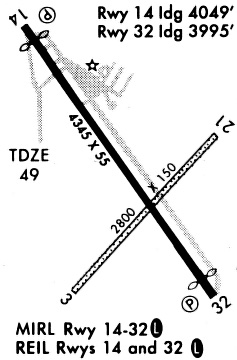
Runway Summary
| Runways: | 03/21 14/32 |
| Longest Runway: | 14/32 is 4323 ft (1318 m) long |
| Runways with an Instrument Approach: |
T69 Airport Runway Details
| Runway 03/21 | 3100 ft x 50 ft (945 m x 15 m) | |
| Runway Length Source: | STATE as of 09/30/2007 | |
| Surface: | Turf - Failed condition - No special surface treatment | |
Runway 03 |
Runway 21 |
|
Elevation: |
47.0 | 47.0 |
Latitude: |
28-02-03.8515N | 28-02-27.0530N |
Longitude: |
097-32-44.6300W | 097-32-21.9810W |
|
Runway True Alignment: |
041 | 221 |
Glide Path Angle: |
0.0 degrees | 0.0 degrees |
Object at End: |
ROAD | PLINE |
Object Height: |
15 | 35 |
Object Marked/Lighted?: |
Lighted | |
Distance from End: |
78 | 400 |
Object Centerline Offset: |
0 ft. left and right of centerline |
| Runway 14/32 | 4323 ft x 55 ft (1318 m x 17 m) | |
| Runway Length Source: | NGS as of 03/04/1998 | |
| Surface: | Turf - Failed condition - No special surface treatment | |
| Runway Edge Lights: | Medium Intensity | |
Runway Weight Bearing Capacity (in thousands of pounds) |
||
| Single Wheel Landing Gear: | 8.0 | |
Runway 14 |
Runway 32 |
|
Elevation: |
46.2 | 46.5 |
Latitude: |
28-02-38.9808N | 28-02-03.5604N |
Longitude: |
097-32-46.3296W | 097-32-19.2476W |
|
Runway True Alignment: |
146 | 326 |
Glide Path Angle: |
3.0 degrees | 3.0 degrees |
Traffic Pattern: |
Left | Left |
Runway Markings Type: |
Nonprecision Instrument | Nonprecision Instrument |
Runway Markings Condition: |
Good | Good |
Object at End: |
ROAD | ROAD |
Object Height: |
20 | 15 |
Distance from End: |
201 | 200 |
Object Centerline Offset: |
0 ft. left and right of centerline | |
Visual Glide Slope Indicators: |
2-Light PAPI On Left Side Of Runway | 2-Light PAPI On Left Side Of Runway |
REIL: |
Yes | Yes |
Threshold Crossing Height: |
19 | 21 |
Threshold Elevation: |
46.7 | 46.9 |
Displaced Threshold: |
250 | 400 |
Threshold Latitude: |
28-02-36.9307N | 28-02-06.8356N |
Threshold Longitude: |
097-32-44.7620W | 097-32-21.7515W |
Services
Airframe Repair: |
None |
Powerplant Repair: |
None |
Bottled Oxygen: |
None |
Bulk Oxygen: |
None |
Fuel Available: |
Jet A |
Landing Fees: |
Yes |
Parking: |
Tiedowns available |
Maps & Diagrams
T69 Sectional
Flight Planning
at skyvector.com
at skyvector.com