Location
Latitude: |
38-15-49.8000N (38.263833) |
Longitude: |
078-53-47.2000W (-78.896444) |
Elevation: |
1201.0 feet MSL (366 m MSL) |
Magnetic Variation: |
9.6 W (as of April 2024 from WMM2020 model) |
Time Zone: |
UTC -5.0 (Standard Time) UTC -4.0 (Daylight Savings Time) |
From City: |
10 N.M. NE of Staunton/Waynesboro/Harrisonburg, Virginia |
Found On: |
Washington Chart |
FAA Region: |
AEA |
Contacts
Manager: |
Publicly owned: |
| LISA BOTKIN 77 AVIATION CIR. WEYERS CAVE, VA 24486 540-234-8304 |
SHENANDOAH VAL REG ARPT COMM 77 AVIATION CIR. WEYERS CAVE, VA 24486 540-234-8304 |
Operations
Airport Status: |
Operational |
Facility Use: |
Public |
Type: |
Airport |
Activation Date: |
08/1958 |
Control tower: |
No |
Attendance (Months/Days/Hours): |
Months/Days/Hours ALL/ALL/ALL |
Boundary ARTCC: |
ZDC (Washington) |
Responsible ARTCC: |
ZDC (Washington) |
Lighting Schedule: |
SEE RMK |
Segmented Circle Indicator: |
No |
Traffic Pattern Altitude (MSL): |
2201 feet (671 m) |
NOTAMs Facility: |
SHD |
NOTAM-D Service: |
Yes |
International Airport of Entry: |
No |
Customs Landing Rights: |
No |
Military Landing Rights: |
Yes |
Civil/Military Joint Use: |
No |
Aircraft Rescue and Firefighting: |
Class I ARFF Index: B Air Carrier Service: Scheduled Certification Date: 05/1973 |
Based Aircraft
| Single Engine: | 55 |
| Multi Engine: | 13 |
| Jet Engine: | 3 |
| GA Helicopters: | 1 |
Annual Operations (as of 12/31/2023)
| Total Operations: | 33294 | |
| Commercial: | 1150 | 3.5% |
| GA Local: | 23990 | 72.1% |
| GA Itinerant: | 7970 | 23.9% |
| Military Aircraft: | 184 | 0.6% |
Communications
| CTAF: | 123.000 |
| Unicom: | 123.000 |
| Clearance Del.: | 118.35 118.35 118.35 |
| Approach: | POTOMAC |
| Departure: | POTOMAC |
| AWOS-3: | 124.925 (540-234-0110) |
- COMMUNICATIONS PRVDD BY LEESBURG RADIO 122.1R/115.3T (MONTEBELLO RCO).
Fixed Based Operators (FBOs) & Fuel
(Click on a business for detail)
Please help us keep this information up to date. This is a FREE SERVICE just like everything else on Airport Guide! If you see that a business needs to be added, modified, or deleted please fill out our Update Form.
To add, modify, or delete a business click here.
Please help us keep this information up to date. This is a FREE SERVICE just like everything else on Airport Guide! If you see that a business needs to be added, modified, or deleted please fill out our Update Form.
Area Code: 540 |
| Business Name | Frequency | Phone | Fuel Grade |
|---|
Flight Service Stations
| Primary | Alternate | |
| FSS on Field: | N | |
| FSS Name (ID): | Leesburg(DCA) | |
| Frequency: | ||
| Toll Free Phone: | 1-800-WX-BRIEF |
Instrument Procedures / Charts
FAA Terminal Procedures valid from 0901Z 03/21/24 to 0901Z 04/18/24.
There are various types of charts available for an airport. They are listed in the Page Type column. Here is a legend for those types:
APD - Airport Diagram
DP - Departure Procedure Charts
HOT - Hot Spots
IAP - Instrument Approach Procedure Charts
MIN - Minimums
STAR - Standard Terminal Arrival Charts
| Page Type | Page Name | Volume | Action Since Last Cycle |
|---|---|---|---|
| DP | SHENANDOAH THREE | NE-3 | |
| IAP | ILS OR LOC RWY 05 | NE-3 | |
| IAP | NDB RWY 05 | NE-3 | |
| IAP | RNAV (GPS) RWY 05 | NE-3 | |
| IAP | RNAV (GPS) RWY 23 | NE-3 | |
| MIN | ALTERNATE MINIMUMS | NE-3 | |
| MIN | TAKEOFF MINIMUMS | NE-3 |
Terminal Procedures are only available for airports in several countries with more being added all the time. If you are looking for a specific country's charts, please send an email to support(at)airportguide.com stating the country name. This will be used to prioritize the implementation.
Navigation Aids (Navaids) near SHD
| Dist (NM) | ID | Morse Code | Name | Type | Freq | True Hdg | Mag Hdg |
|---|---|---|---|---|---|---|---|
| 4.7 | SH | . . . . . . . | Staut | NDB | 375 | 217 | 227 |
| 23.5 | AZS | . _ _ _ . . . . . | Azalea Park | NDB | 336 | 130 | 140 |
| 24.0 | MOL | _ _ _ _ _ . _ . . | Montebello | VOR-DME | 115.30 | 204 | 214 |
| 32.9 | LUA | . _ . . . . _ . _ | Caverns | NDB | 245 | 37 | 47 |
| 38.2 | GVE | _ _ . . . . _ . | Gordonsville | VORTAC | 115.60 | 112 | 122 |
| 48.0 | MSQ | _ _ . . . _ _ . _ | Nailr | NDB | 351 | 75 | 85 |
| 48.0 | LDN | . _ . . _ . . _ . | Linden | VORTAC | 114.30 | 42 | 52 |
| 53.5 | CSN | _ . _ . . . . _ . | Casanova | VORTAC | 116.30 | 64 | 74 |
| 57.9 | ESL | . . . . . _ . . | Kessel | VOR-DME | 110.80 | 355 | 365 |
| 58.8 | FVX | . . _ . . . . _ _ . . _ | Farmville | NDB | 367 | 158 | 168 |
| 58.9 | RQY | . _ . _ _ . _ _ . _ _ | Randolph County | NDB | 284 | 310 | 319 |
| 62.3 | LY | . _ . . _ . _ _ | Bojar | NDB | 385 | 195 | 204 |
| 62.7 | LYH | . _ . . _ . _ _ . . . . | Lynchburg | VOR-DME | 109.20 | 195 | 204 |
| 64.9 | GDX | _ _ . _ . . _ . . _ | Goodwin Lake | NDB | 227 | 50 | 60 |
| 67.1 | FAK | . . _ . . _ _ . _ | Flat Rock | VORTAC | 113.30 | 130 | 140 |
| 68.1 | EZF | . _ _ . . . . _ . | Shannon | NDB | 237 | 89 | 99 |
| 68.6 | EKN | . _ . _ _ . | Elkins | VORTAC | 114.20 | 305 | 314 |
| 72.8 | BRV | _ . . . . _ . . . . _ | Brooke | VORTAC | 114.50 | 86 | 96 |
| 74.6 | LWB | . _ . . . _ _ _ . . . | Greenbrier | DME | 116.05 | 251 | 260 |
| 76.2 | ODR | _ _ _ _ . . . _ . | Woodrum | VOR | 114.90 | 222 | 231 |
Nearby Airports with Fuel
Notices to Airmen (NOTAMS)
Remarks
| A110-2 | FOR CD CTC POTOMAC APCH AT 866-640-4124. |
| A26 | PPR 12 HRS FOR UNSKED ACR OPNS WITH MORE THAN 30 PSGR SEATS CALL 540-234-8304. |
| A81-APT | ACTVT MALSR RWY 05; REIL RWY 23; HIRL RWY 05/23 & TWY LGTS - CTAF. PAPI RWY 05 & 23 OPRS CONSLY. |
| E147 | TPA 800 FT PISTON ACFT, 1500 FT JET/TURBO ACFT. |
Runways
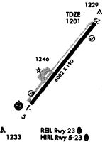
Runway Summary
| Runways: | 05/23 |
| Longest Runway: | 05/23 is 6002 ft (1829 m) long |
| Runways with an Instrument Approach: | 05 |
SHD Airport Runway Details
| Runway 05/23 | 6002 ft x 150 ft (1829 m x 46 m) | |
| Runway Length Source: | 3RD PARTY SURVEY as of 11/12/2014 | |
| Surface: | Asphalt - Good condition - Saw-cut or plastic grooved | |
| Runway Pavement Class: | 44 /F/B/X/U | |
| Runway Edge Lights: | High Intensity | |
Runway Weight Bearing Capacity (in thousands of pounds) |
||
| Single Wheel Landing Gear: | 75.0 | |
| Dual Wheel Landing Gear: | 150.0 | |
| Dual Tandem Wheel Landing Gear: | 215.0 | |
Runway 05 |
Runway 23 |
|
Elevation: |
1174.3 | 1200.9 |
Latitude: |
38-15-26.5226N | 38-16-13.1431N |
Longitude: |
078-54-10.4223W | 078-53-23.8822W |
|
Runway True Alignment: |
038 | 218 |
ILS Type: |
ILS | |
Glide Path Angle: |
3.0 degrees | 3.0 degrees |
Traffic Pattern: |
Left | Left |
Runway Markings Type: |
Precision Instrument | Nonprecision Instrument |
Runway Markings Condition: |
Good | Good |
Object at End: |
POLE | |
Object Height: |
59 | |
Object Marked/Lighted?: |
Lighted | |
Distance from End: |
2500 | |
Object Centerline Offset: |
300 ft. left of centerline | |
Visual Glide Slope Indicators: |
4-Light PAPI On Left Side Of Runway | 4-Light PAPI On Left Side Of Runway |
Approach Light System: |
1,400 Foot Medium Intensity Approach Lighting System With Runway Alignment Indicator Lights | |
REIL: |
Yes | |
Threshold Crossing Height: |
56 | 44 |
Declared Distances |
||
Take Off Run Avbl. (TORA): |
6002 | 6002 |
Take Off Distance Avbl. (TODA): |
6002 | 6002 |
Actual Stop Dist. Avbl. (ASDA): |
6002 | 6002 |
Landing Dist. Avbl. (LDA): |
6002 | 6002 |
Services
Airframe Repair: |
Major |
Powerplant Repair: |
Major |
Bottled Oxygen: |
High Pressure |
Fuel Available: |
100LL, Jet A |
Landing Fees: |
No |
Parking: |
Hangars and tiedowns available |
Maps & Diagrams
SHD Sectional
Flight Planning
at skyvector.com
at skyvector.com