Location
Latitude: |
39-31-35.7840N (39.526607) |
Longitude: |
107-43-40.7530W (-107.727987) |
Elevation: |
5536.8 feet MSL (1688 m MSL) |
Magnetic Variation: |
9 E (as of April 2024 from WMM2020 model) |
Time Zone: |
UTC -7.0 (Standard Time) UTC -6.0 (Daylight Savings Time) |
From City: |
03 N.M. E of Rifle, Colorado |
Found On: |
Denver Chart |
FAA Region: |
ANM |
Contacts
Manager: |
Publicly owned: |
| BRIAN CONDIE 0375 COUNTY RD 352 BLDG 2060 RIFLE, CO 81650 970-625-1091 |
GARFIELD COUNTY 0375 COUNTY RD 352 BLDG 2060 RIFLE, CO 81650 970-625-1091 |
Operations
Airport Status: |
Operational |
Facility Use: |
Public |
Type: |
Airport |
Activation Date: |
07/1940 |
Control tower: |
No |
Attendance (Months/Days/Hours): |
Months/Days/Hours ALL/ALL/ALL |
Boundary ARTCC: |
ZDV (Denver) |
Responsible ARTCC: |
ZDV (Denver) |
Lighting Schedule: |
SEE RMK |
Segmented Circle Indicator: |
Yes |
Traffic Pattern Altitude (MSL): |
6537 feet (1992 m) |
NOTAMs Facility: |
RIL |
NOTAM-D Service: |
Yes |
International Airport of Entry: |
No |
Customs Landing Rights: |
No |
Military Landing Rights: |
Yes |
Civil/Military Joint Use: |
No |
Based Aircraft
| Single Engine: | 16 |
| Multi Engine: | 3 |
| Jet Engine: | 2 |
| Gliders: | 1 |
Annual Operations (as of 12/31/2018)
| Total Operations: | 14382 | |
| Air Taxi: | 2300 | 16.0% |
| GA Local: | 4760 | 33.1% |
| GA Itinerant: | 7292 | 50.7% |
| Military Aircraft: | 30 | 0.2% |
Communications
| CTAF: | 122.800 |
| Unicom: | 122.800 |
| ASOS: | 135.275 (970-625-2206) |
- APCH/DEP CTL SVC PRVDD BY DENVER ARTCC (ZDV) ON FREQS 134.95/327.075 (RIFLE RCAG).
Fixed Based Operators (FBOs) & Fuel
(Click on a business for detail)
Please help us keep this information up to date. This is a FREE SERVICE just like everything else on Airport Guide! If you see that a business needs to be added, modified, or deleted please fill out our Update Form.
To add, modify, or delete a business click here.
Please help us keep this information up to date. This is a FREE SERVICE just like everything else on Airport Guide! If you see that a business needs to be added, modified, or deleted please fill out our Update Form.
Area Code: 970 |
| Business Name | Frequency | Phone | Fuel Grade |
|---|---|---|---|
| Corporate Aircraft Services
Update FBO info |
Unicom 122.8 | 625-3771 | 100LL, Jet A |
| JP Avionics
Update FBO info |
625-1319 | ||
| Precision Aircraft Maintenance
Update FBO info |
625-5027 |
Flight Service Stations
| Primary | Alternate | |
| FSS on Field: | N | |
| FSS Name (ID): | Denver(DEN) | |
| Frequency: | ||
| Toll Free Phone: | 1-800-WX-BRIEF |
Instrument Procedures / Charts
FAA Terminal Procedures valid from 0901Z 03/21/24 to 0901Z 04/18/24.
There are various types of charts available for an airport. They are listed in the Page Type column. Here is a legend for those types:
APD - Airport Diagram
DP - Departure Procedure Charts
HOT - Hot Spots
IAP - Instrument Approach Procedure Charts
MIN - Minimums
STAR - Standard Terminal Arrival Charts
| Page Type | Page Name | Volume | Action Since Last Cycle |
|---|---|---|---|
| DP | EDUKY FIVE (RNAV) | SW-1 | |
| DP | UYRIG FIVE (RNAV) | SW-1 | |
| IAP | ILS RWY 26 | SW-1 | |
| IAP | LOC/DME-A | SW-1 | |
| IAP | RNAV (GPS) W RWY 26 | SW-1 | |
| IAP | RNAV (GPS) X RWY 26 | SW-1 | |
| IAP | RNAV (GPS) Y RWY 08 | SW-1 | |
| IAP | RNAV (RNP) Y RWY 26 | SW-1 | |
| IAP | RNAV (RNP) Z RWY 08 | SW-1 | |
| IAP | RNAV (RNP) Z RWY 26 | SW-1 | |
| IAP | VOR/DME-C | SW-1 | |
| MIN | ALTERNATE MINIMUMS | SW-1 | |
| MIN | TAKEOFF MINIMUMS | SW-1 | |
| ODP | SQUAT FIVE (OBSTACLE) (RNAV) | SW-1 |
Terminal Procedures are only available for airports in several countries with more being added all the time. If you are looking for a specific country's charts, please send an email to support(at)airportguide.com stating the country name. This will be used to prioritize the implementation.
Navigation Aids (Navaids) near RIL
| Dist (NM) | ID | Morse Code | Name | Type | Freq | True Hdg | Mag Hdg |
|---|---|---|---|---|---|---|---|
| 0.4 | RIL | . _ . . . . _ . . | Rifle | VOR-DME | 113.35 | 75 | 66 |
| 33.7 | EKR | . _ . _ . _ . | Meeker | VOR-DME | 115.20 | 344 | 335 |
| 34.6 | SXW | . . . _ . . _ . _ _ | Snow | VOR-DME | 109.20 | 79 | 70 |
| 38.9 | DBL | _ . . _ . . . . _ . . | Red Table | VOR-DME | 113.00 | 97 | 88 |
| 44.5 | RDY | . _ . _ . . _ . _ _ | Sardy | TACAN | 114.30 | 114 | 105 |
| 56.8 | JNC | . _ _ _ _ . _ . _ . | Grand Junction | VOR-DME | 112.40 | 240 | 231 |
| 61.7 | MTJ | _ _ _ . _ _ _ | Montrose | VOR-DME | 117.10 | 187 | 178 |
| 62.7 | CHE | _ . _ . . . . . . | Hayden | VOR-DME | 115.60 | 17 | 8 |
| 65.8 | RLG | . _ . . _ . . _ _ . | Kremmling | VOR-DME | 113.80 | 63 | 54 |
| 68.6 | BQZ | _ . . . _ _ . _ _ _ . . | Robert | VOR-DME | 112.20 | 34 | 25 |
| 72.0 | HBU | . . . . _ . . . . . _ | Blue Mesa | VOR-DME | 114.90 | 153 | 144 |
| 92.6 | ETL | . _ . _ . . | Cones | VOR-DME | 110.20 | 195 | 186 |
| 96.0 | VEL | . . . _ . . _ . . | Vernal | VOR-DME | 108.20 | 302 | 293 |
Nearby Airports with Fuel
Notices to Airmen (NOTAMS)
Remarks
| A110-10 | IFR ATC CLNC FM RIL IS NOT AUTH TO ENTER RWY OR TKOF & LNDG. |
| A110-11 | SATURATED PAT POLICY: TGLS PROHIBITED WHEN 5 OR MORE ACFT IN TFC PATTERN. |
| A110-12 | FLW FAA PROCS FOR NON-TOWERED ARPTS. |
| A110-13 | CTN: SN REMOVAL EQUIP OPS FM 1 OCT TO 15 MAY. |
| A110-2 | AFT WINTER SN STORMS ARPT OPNS BFR ALL TWYS ARE CLEARED. |
| A110-3 | OVNGT PRKG FEE. |
| A110-4 | COLD TEMP ARPT. ALT COR RQRD AT OR BELOW -14C. |
| A110-5 | FOR CD, IFUN TO CTC ON DENVER ARTCC APP/DEP CTL FREQ, CTC DENVER ARTCC AT 303-651-4257. |
| A110-6 | GLD OPS INVOF ARPT. |
| A110-7 | PROPER DUAL RDO USE (ATC/CTAF) IS ESNTL FOR SAFE AND EFFICIENT TFC FLOW. |
| A110-9 | USE CTAF PRIOR TO ENTERING RWY OR PAT. |
| A70-FUEL-10 | 0LL ARPT OPS-24 HRS / 970-230-1685. |
| A81-APT | ACTVT ODALS RWY 26; REIL RWY 08; HIRL RWY 08/26 - CTAF. PAPI RWY 08 & 26 ON CONSLY. |
| E80A | FOR ACFT GWT 10000 LBS OR MORE. |
Runways
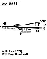
Runway Summary
| Runways: | 08/26 |
| Longest Runway: | 08/26 is 7000 ft (2134 m) long |
| Runways with an Instrument Approach: | 26 |
RIL Airport Runway Details
| Runway 08/26 | 7000 ft x 100 ft (2134 m x 30 m) | |
| Runway Length Source: | 3RD PARTY SURVEY as of 09/04/2020 | |
| Surface: | Asphalt - Good condition - Saw-cut or plastic grooved | |
| Runway Pavement Class: | 43 /F/B/X/U | |
| Runway Edge Lights: | High Intensity | |
Runway Weight Bearing Capacity (in thousands of pounds) |
||
| Single Wheel Landing Gear: | 90.0 | |
| Dual Wheel Landing Gear: | 200.0 | |
| Dual Tandem Wheel Landing Gear: | 250.0 | |
Runway 08 |
Runway 26 |
|
Elevation: |
5470.2 | 5536.8 |
Latitude: |
39-31-34.8475N | 39-31-36.7163N |
Longitude: |
107-44-25.3928W | 107-42-56.1138W |
|
Runway True Alignment: |
088 | 268 |
ILS Type: |
ILS/DME | |
Glide Path Angle: |
3.0 degrees | 3.5 degrees |
Traffic Pattern: |
Left | Right |
Runway Markings Type: |
Nonprecision Instrument | Precision Instrument |
Runway Markings Condition: |
Good | Good |
Visual Glide Slope Indicators: |
4-Light PAPI On Left Side Of Runway | 4-Light PAPI On Left Side Of Runway |
Approach Light System: |
Omnidirectional Approach Lighting System | |
REIL: |
Yes | No |
Threshold Crossing Height: |
47 | 56 |
Services
Bottled Oxygen: |
None |
Bulk Oxygen: |
None |
Fuel Available: |
100LL, Jet A |
Landing Fees: |
No |
Parking: |
Tiedowns available |
Maps & Diagrams
RIL Sectional
Flight Planning
at skyvector.com
at skyvector.com