Location
Latitude: |
41-43-20.4000N (41.722333) |
Longitude: |
071-25-39.8000W (-71.427722) |
Elevation: |
54.0 feet MSL (16 m MSL) |
Magnetic Variation: |
13.9 W (as of April 2024 from WMM2020 model) |
Time Zone: |
UTC -5.0 (Standard Time) UTC -4.0 (Daylight Savings Time) |
From City: |
06 N.M. S of Providence, Rhode Island |
Found On: |
New York Chart |
FAA Region: |
ANE |
Contacts
Manager: |
Publicly owned: |
| IFTIKHAR AHMAD RI AIRPORT CORP, 2000 POST RD WARWICK, RI 02886 401-691-2000 |
STATE OF RHODE ISLAND RI AIRPORT CORP, 2000 POST RD WARWICK, RI 02886 401-691-2000 |
Operations
Airport Status: |
Operational |
Facility Use: |
Public |
Type: |
Airport |
Activation Date: |
09/1937 |
Control tower: |
Yes |
Attendance (Months/Days/Hours): |
Months/Days/Hours ALL/ALL/ALL |
Boundary ARTCC: |
ZBW (Boston) |
Responsible ARTCC: |
ZBW (Boston) |
Lighting Schedule: |
SEE RMK |
Segmented Circle Indicator: |
Yes |
Traffic Pattern Altitude (MSL): |
1054 feet (321 m) |
NOTAMs Facility: |
PVD |
NOTAM-D Service: |
Yes |
International Airport of Entry: |
No |
Customs Landing Rights: |
Yes |
Military Landing Rights: |
Yes |
Civil/Military Joint Use: |
No |
Aircraft Rescue and Firefighting: |
Class I ARFF Index: C Air Carrier Service: Scheduled Certification Date: 05/1973 |
Based Aircraft
| Single Engine: | 25 |
| Multi Engine: | 1 |
| Jet Engine: | 8 |
| GA Helicopters: | 3 |
Annual Operations (as of 03/31/2023)
| Total Operations: | 66101 | |
| Commercial: | 33013 | 49.9% |
| Air Taxi: | 8337 | 12.6% |
| GA Local: | 8918 | 13.5% |
| GA Itinerant: | 15166 | 22.9% |
| Military Aircraft: | 667 | 1.0% |
Communications
| CTAF: | 120.700 |
| Tower: | PROVIDENCE 120.7 257.8 Hrs: SUN-FRI 0530-0030 SAT 0530-0000 |
| Clearance Del.: | 126.65 348.6 |
| Ground: | 121.9 348.6 |
| Approach: | PROVIDENCE 123.675 244.875 Hrs: SUN-FRI 0530-0030 SAT 0530-0000 BOSTON ARTCC |
| Departure: | PROVIDENCE 123.675 244.875 Hrs: SUN-FRI 0530-0030 SAT 0530-0000 BOSTON ARTCC |
| ATIS: | 124.2 Hrs: 24 |
| ASOS: | 124.2 (401-734-2818) |
| EMERG: | 121.5 |
| CLASS C: | 244.875 |
| WIPOR STAR: | 244.875 |
| CLASS C: | 123.675 |
| WIPOR STAR: | 123.675 |
| COMD POST: | 383.3 |
| EMERG: | 243.0 |
- APCH/DEP SVC PRVDD BY BOSTON ARTCC ON FREQS 124.85/307.9 (WOODSTOCK RCAG) WHEN APCH CTL CLSD.
Fixed Based Operators (FBOs) & Fuel
(Click on a business for detail)
Please help us keep this information up to date. This is a FREE SERVICE just like everything else on Airport Guide! If you see that a business needs to be added, modified, or deleted please fill out our Update Form.
To add, modify, or delete a business click here.
Please help us keep this information up to date. This is a FREE SERVICE just like everything else on Airport Guide! If you see that a business needs to be added, modified, or deleted please fill out our Update Form.
Area Code: 401 |
| Business Name | Frequency | Phone | Fuel Grade |
|---|---|---|---|
| Air Sales, Inc.
Update FBO info |
737-6800 | ||
| Helicopter Services
Update FBO info |
739-0363 | ||
| Newport Limousine, LLC
Website Update FBO info |
401-846-3500, cell phone 401-862-4855 | ||
| Northstar Aviation
Update FBO info |
738-2600 | 100LL, Jet A |
Flight Service Stations
| Primary | Alternate | |
| FSS on Field: | N | |
| FSS Name (ID): | Bridgeport(BDR) | |
| Frequency: | ||
| Toll Free Phone: | 1-800-WX-BRIEF |
Instrument Procedures / Charts
FAA Terminal Procedures valid from 0901Z 03/21/24 to 0901Z 04/18/24.
There are various types of charts available for an airport. They are listed in the Page Type column. Here is a legend for those types:
APD - Airport Diagram
DP - Departure Procedure Charts
HOT - Hot Spots
IAP - Instrument Approach Procedure Charts
MIN - Minimums
STAR - Standard Terminal Arrival Charts
| Page Type | Page Name | Volume | Action Since Last Cycle |
|---|---|---|---|
| APD | AIRPORT DIAGRAM | NE-1 | |
| HOT | HOT SPOT | NE-1 | |
| IAP | ILS OR LOC RWY 05 | NE-1 | |
| IAP | ILS OR LOC RWY 23 | NE-1 | |
| IAP | ILS OR LOC RWY 34 | NE-1 | |
| IAP | ILS RWY 05 (CAT II - III) | NE-1 | |
| IAP | ILS RWY 23 (SA CAT I - II) | NE-1 | |
| IAP | RNAV (GPS) RWY 05 | NE-1 | |
| IAP | RNAV (GPS) RWY 16 | NE-1 | |
| IAP | RNAV (GPS) RWY 34 | NE-1 | |
| IAP | RNAV (GPS) Y RWY 23 | NE-1 | |
| IAP | RNAV (RNP) Z RWY 23 | NE-1 | |
| IAP | VOR RWY 05 | NE-1 | |
| IAP | VOR Y RWY 34 | NE-1 | |
| IAP | VOR Z RWY 34 | NE-1 | |
| IAP | VOR/DME RWY 16 | NE-1 | |
| IAP | VOR/DME RWY 23 | NE-1 | |
| MIN | ALTERNATE MINIMUMS | NE-1 | |
| MIN | TAKEOFF MINIMUMS | NE-1 | |
| STAR | JORDN TWO (RNAV) | NE-1 | |
| STAR | WIPOR THREE (RNAV) | NE-1 |
Terminal Procedures are only available for airports in several countries with more being added all the time. If you are looking for a specific country's charts, please send an email to support(at)airportguide.com stating the country name. This will be used to prioritize the implementation.
Navigation Aids (Navaids) near PVD
| Dist (NM) | ID | Morse Code | Name | Type | Freq | True Hdg | Mag Hdg |
|---|---|---|---|---|---|---|---|
| 0.1 | PVD | . _ _ . . . . _ _ . . | Providence | VOT | 108.20 | 31 | 45 |
| 0.1 | PVD | . _ _ . . . . _ _ . . | Providence | VOR-DME | 115.60 | 324 | 338 |
| 6.2 | AR | . _ . _ . | Armin | NDB | 356 | 32 | 46 |
| 19.7 | IHM | . . . . . . _ _ | Mansfield | NDB | 220 | 31 | 45 |
| 20.6 | TAN | _ . _ _ . | Taunton | NDB | 227 | 63 | 77 |
| 23.3 | PUT | . _ _ . . . _ _ | Putnam | VOR-DME | 117.40 | 307 | 321 |
| 27.3 | OW | _ _ _ . _ _ | Stoge | NDB | 397 | 29 | 43 |
| 27.5 | ORW | _ _ _ . _ . . _ _ | Norwich | VOR-DME | 110.00 | 248 | 262 |
| 34.0 | SEY | . . . . _ . _ _ | Sandy Point | VOR-DME | 117.80 | 191 | 205 |
| 36.6 | GON | _ _ . _ _ _ _ . | Groton | VOR-DME | 110.85 | 230 | 244 |
| 36.8 | GON | _ _ . _ _ _ _ . | Groton | VOT | 110.25 | 229 | 243 |
| 38.1 | ORH | _ _ _ . _ . . . . . | Worcester | VOT | 108.20 | 329 | 343 |
| 40.4 | IMR | . . _ _ . _ . | Marshfield | NDB | 368 | 55 | 69 |
| 41.1 | FMH | . . _ . _ _ . . . . | Otis | TACAN | 115.80 | 94 | 108 |
| 41.5 | MVY | _ _ . . . _ _ . _ _ | Marthas Vineyard | VOR-DME | 114.50 | 117 | 131 |
| 42.8 | BOS | _ . . . _ _ _ . . . | Boston | VOT | 111.00 | 26 | 40 |
| 42.8 | BOS | _ . . . _ _ _ . . . | Boston | VOR-DME | 112.70 | 26 | 40 |
| 44.2 | FM | . . _ . _ _ | Bomde | NDB | 362 | 88 | 102 |
| 45.0 | BED | _ . . . . _ . . | Bedford | VOT | 110.00 | 7 | 21 |
| 45.4 | SKR | . . . _ . _ . _ . | Shaker Hill | NDB | 251 | 14 | 28 |
Nearby Airports with Fuel
Notices to Airmen (NOTAMS)
Remarks
| A110-1 | GND VEHICLES MNT CTAF WHEN ATCT CLSD. |
| A110-23 | TRML RAMP PROHIBITED FOR USE BY GA. |
| A110-24 | TWY V CLSD DLY 2000-0800 BTN RWY 16/34 AND TWY C. |
| A110-26 | ASDE-X IN USE. OPR TRANSPONDERS WITH ALT RPRTG MODE AND ADS-B (IF EQUIPPED) ENABLED ON ALL ARPT SFCS. |
| A110-27 | PARKED ACFT ON THE NE RAMP WEST OF TWY A, BE ALERT. FQT FLT SCHOOL, TSNT JET ACFT, AND VER ACTVTY. |
| A110-28 | NE RAMP ACFT WITH WINGSPAN GTR THAN 150 FT RQR GND CREW ASSISTANCE FOR THRU TAXI AND PRKG. |
| A110-29 | FOR CD WHEN APCH CLSD CTC BOSTON ARTCC AT 603-879-6859. |
| A110-3 | DEER & BIRDS ON & INVOF ARPT. |
| A110-4 | 110 FT UNMKD LGT POLES, 2700 FT FM THR RWY 34, 900 FT LEFT OF CNTRLN. |
| A110-5 | RUN UP PAD FOR TWY F CLSD TO ACFT WITH WINGSPAN OVER 118 FT. |
| A110-8 | NOISE ABATEMENT PROCS IN EFCT. HELS AVOID RESL AREAS WHEN BLW 1000 FT. |
| A110-9 | NW RAMP ACFT WITH WINGSPAN GTR THAN 110 FT RQR GND CREW ASSISTANCE FOR THRU TAXI AND PRKG. |
| A57-16 | 54 FT TREES 700 FT R OF CNTRLN 2000 FT FM RWY END. 37:1 TO DTHR. |
| A81-APT | WHEN ATCT CLSD, ALSF-2 BCMS SSALS PRESET MED INTST ONLY. WHEN ATCT CLSD, ACTVT MALSR RWY 23 & 34; REIL RWY 16; PAPI RWY 05, 16 & 34; VASI RWY 23; TDZ RWY 05; CNTLN RWY 5/23; HIRL RWY 5/23 & 16/34 - CTAF. |
| E111 | EXISTED PRIOR TO 1959. |
| E60-34 | ENGINEERED MATERIAL ARRESTING SYSTEM (EMAS) 255 FT IN LENGTH BY 170 FT IN WIDTH LCTD AT DER. |
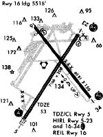
Runways
Runway Summary
| Runways: | 05/23 16/34 |
| Longest Runway: | 05/23 is 8700 ft (2652 m) long |
| Runways with an Instrument Approach: | 05, 23, 34 |
PVD Airport Runway Details
| Runway 05/23 | 8700 ft x 150 ft (2652 m x 46 m) | |
| Runway Length Source: | 3RD PARTY SURVEY as of 01/15/2016 | |
| Surface: | Asphalt - Fair condition - Saw-cut or plastic grooved | |
| Runway Pavement Class: | 75 /F/A/W/T | |
| Runway Edge Lights: | High Intensity | |
Runway Weight Bearing Capacity (in thousands of pounds) |
||
| Single Wheel Landing Gear: | 120.0 | |
| Dual Wheel Landing Gear: | 250.0 | |
| Dual Tandem Wheel Landing Gear: | 550.0 | |
| Dual Dual Tandem Wheel Landing Gear: | 1120.0 | |
Runway 05 |
Runway 23 |
|
Elevation: |
52.9 | 44.3 |
Latitude: |
41-42-36.9418N | 41-43-49.6987N |
Longitude: |
071-26-16.6176W | 071-25-15.5316W |
|
Runway True Alignment: |
032 | 212 |
ILS Type: |
ILS/DME | ILS/DME |
Glide Path Angle: |
3.0 degrees | 3.0 degrees |
Traffic Pattern: |
Left | Left |
Runway Markings Type: |
Precision Instrument | Precision Instrument |
Runway Markings Condition: |
Good | Good |
Arresting Device: |
EMAS | |
Object at End: |
TREES | TREES |
Object Height: |
56 | 50 |
Distance from End: |
2475 | 2185 |
Object Centerline Offset: |
600 ft. right of centerline | 790 ft. right of centerline |
Visual Glide Slope Indicators: |
4-Light PAPI On Right Side Of Runway | 4-Box VASI On Left Side Of Runway |
Runway Visual Range (RVR): |
Touchdown, Midfield, Rollout | Touchdown, Midfield, Rollout |
Approach Light System: |
Standard 2,400 Foot High Intensity Approach Lighting System With Sequenced Flashers, Cat. II or III Config. | 1,400 Foot Medium Intensity Approach Lighting System With Runway Alignment Indicator Lights |
REIL: |
No | No |
Touchdown Lights: |
Yes | No |
Centerline Lights: |
Yes | Yes |
Threshold Crossing Height: |
69 | 41 |
Declared Distances |
||
Take Off Run Avbl. (TORA): |
8700 | 8700 |
Take Off Distance Avbl. (TODA): |
8700 | 8700 |
Actual Stop Dist. Avbl. (ASDA): |
8700 | 8700 |
Landing Dist. Avbl. (LDA): |
8700 | 8700 |
| Runway 16/34 | 6081 ft x 150 ft (1853 m x 46 m) | |
| Runway Length Source: | 3RD PARTY SURVEY as of 01/15/2016 | |
| Surface: | Asphalt - Fair condition - Saw-cut or plastic grooved | |
| Runway Pavement Class: | 75 /F/A/W/T | |
| Runway Edge Lights: | High Intensity | |
Runway Weight Bearing Capacity (in thousands of pounds) |
||
| Single Wheel Landing Gear: | 120.0 | |
| Dual Wheel Landing Gear: | 250.0 | |
| Dual Tandem Wheel Landing Gear: | 423.0 | |
| Dual Dual Tandem Wheel Landing Gear: | 1093.0 | |
Runway 16 |
Runway 34 |
|
Elevation: |
53.7 | 32.8 |
Latitude: |
41-43-53.9558N | 41-43-06.8856N |
Longitude: |
071-25-55.8292W | 071-25-05.9967W |
|
Runway True Alignment: |
142 | 322 |
ILS Type: |
ILS/DME | |
Glide Path Angle: |
3.0 degrees | 3.0 degrees |
Traffic Pattern: |
Left | Left |
Runway Markings Type: |
Precision Instrument | Precision Instrument |
Runway Markings Condition: |
Good | Good |
Arresting Device: |
EMAS | EMAS |
Object at End: |
POLE | TREES |
Object Height: |
19 | 39 |
Distance from End: |
560 | 1400 |
Object Centerline Offset: |
600 ft. right of centerline | 790 ft. right of centerline |
Visual Glide Slope Indicators: |
4-Light PAPI On Left Side Of Runway | 4-Light PAPI On Left Side Of Runway |
Runway Visual Range (RVR): |
Rollout | Touchdown |
Approach Light System: |
1,400 Foot Medium Intensity Approach Lighting System With Runway Alignment Indicator Lights | |
REIL: |
Yes | No |
Threshold Crossing Height: |
49 | 60 |
Threshold Elevation: |
54.0 | |
Displaced Threshold: |
565 | |
Threshold Latitude: |
41-43-49.5831N | |
Threshold Longitude: |
071-25-51.1998W | |
Declared Distances |
||
Take Off Run Avbl. (TORA): |
6081 | 6081 |
Take Off Distance Avbl. (TODA): |
6081 | 6081 |
Actual Stop Dist. Avbl. (ASDA): |
6081 | 6081 |
Landing Dist. Avbl. (LDA): |
5516 | 6081 |
Services
Airframe Repair: |
Major |
Powerplant Repair: |
Major |
Bottled Oxygen: |
None |
Bulk Oxygen: |
None |
Fuel Available: |
100LL |
Landing Fees: |
No |
Parking: |
Hangars and tiedowns available |
Maps & Diagrams
PVD Sectional
Flight Planning
at skyvector.com
at skyvector.com