
Location
Latitude: |
33-49-46.8000N (33.829667) |
Longitude: |
116-30-24.1000W (-116.506694) |
Elevation: |
476.4 feet MSL (145 m MSL) |
Magnetic Variation: |
11.1 E (as of April 2024 from WMM2020 model) |
Time Zone: |
UTC -8.0 (Standard Time) UTC -7.0 (Daylight Savings Time) |
From City: |
02 N.M. E of Palm Springs, California |
Found On: |
Los Angeles Chart |
FAA Region: |
AWP |
Contacts
Manager: |
Publicly owned: |
| HARRY BARRETT 3400 E. TAHQUITZ-CANYON WAY, SUITE OFC PALM SPRINGS, CA 92262 760-318-3845 |
CITY OF PALM SPRINGS 3400 E. TAHQUITZ CANYON WAY PALM SPRINGS, CA 92262 760-318-3800 |
Operations
Airport Status: |
Operational |
Facility Use: |
Public |
Type: |
Airport |
Activation Date: |
07/1942 |
Control tower: |
Yes |
Attendance (Months/Days/Hours): |
Months/Days/Hours ALL/ALL/ALL |
Boundary ARTCC: |
ZLA (Los Angeles) |
Responsible ARTCC: |
ZLA (Los Angeles) |
Lighting Schedule: |
SEE RMK |
Segmented Circle Indicator: |
Yes |
Traffic Pattern Altitude (MSL): |
1476 feet (450 m) |
NOTAMs Facility: |
PSP |
NOTAM-D Service: |
Yes |
International Airport of Entry: |
No |
Customs Landing Rights: |
No |
Military Landing Rights: |
Yes |
Civil/Military Joint Use: |
No |
Aircraft Rescue and Firefighting: |
Class I ARFF Index: C Air Carrier Service: Scheduled Certification Date: 05/1973 |
Based Aircraft
| Single Engine: | 57 |
| Multi Engine: | 2 |
| Jet Engine: | 9 |
| GA Helicopters: | 1 |
Annual Operations (as of 12/31/2022)
| Total Operations: | 61642 | |
| Commercial: | 29720 | 48.2% |
| Air Taxi: | 10822 | 17.6% |
| GA Local: | 2779 | 4.5% |
| GA Itinerant: | 17147 | 27.8% |
| Military Aircraft: | 1174 | 1.9% |
Communications
| CTAF: | 119.700 |
| Unicom: | 122.950 |
| Tower: | PALM SPRINGS 119.7 377.05 Hrs: 0600-2300 |
| Clearance Del.: | 128.35 |
| Ground: | 121.9 |
| Approach: | SOCAL |
| Departure: | SOCAL |
| ATIS: | 124.65 Hrs: 24 |
| ASOS: | (760-322-7597) |
| EMERG: | 121.5 |
| EMERG: | 234.0 |
Fixed Based Operators (FBOs) & Fuel
(Click on a business for detail)
Please help us keep this information up to date. This is a FREE SERVICE just like everything else on Airport Guide! If you see that a business needs to be added, modified, or deleted please fill out our Update Form.
To add, modify, or delete a business click here.
Please help us keep this information up to date. This is a FREE SERVICE just like everything else on Airport Guide! If you see that a business needs to be added, modified, or deleted please fill out our Update Form.
Area Code: 760 |
| Business Name | Frequency | Phone | Fuel Grade |
|---|---|---|---|
| Air Palm Springs
Update FBO info |
322-1104 | ||
| California Eagles International Flight Training
Update FBO info |
322-7703 | ||
| Jet Valley Aviation
Update FBO info |
864-4110 | ||
| L08 Aircraft Maintenance
Update FBO info |
323-7036 | ||
| Million Air
Update FBO info |
Unicom 122.95, Arinc 129.975 | 320-7704, 800-833-3013 | 100LL, Jet A |
| Palm Springs Air Museum
Update FBO info |
778-6262 | ||
| Signature Flight Support
Website Update FBO info |
Unicom: 122.95, Arinc: 129.72 | +1 760 327 1201 | 100LL, Jet A |
| The Flight School at Palm Springs
Update FBO info |
416-2188 |
Flight Service Stations
| Primary | Alternate | |
| FSS on Field: | N | |
| FSS Name (ID): | Riverside(RAL) | |
| Frequency: | ||
| Toll Free Phone: | 1-800-WX-BRIEF |
Instrument Procedures / Charts
FAA Terminal Procedures valid from 0901Z 03/21/24 to 0901Z 04/18/24.
There are various types of charts available for an airport. They are listed in the Page Type column. Here is a legend for those types:
APD - Airport Diagram
DP - Departure Procedure Charts
HOT - Hot Spots
IAP - Instrument Approach Procedure Charts
MIN - Minimums
STAR - Standard Terminal Arrival Charts
| Page Type | Page Name | Volume | Action Since Last Cycle |
|---|---|---|---|
| APD | AIRPORT DIAGRAM | SW-3 | |
| DP | CATHEDRAL ONE | SW-3 | |
| DP | THERMAL SIX | SW-3 | |
| HOT | HOT SPOT | SW-3 | |
| IAP | RNAV (GPS) Z RWY 31L | SW-3 | |
| IAP | RNAV (RNP) Y RWY 31L | SW-3 | |
| IAP | RNAV (RNP) Z RWY 13R | SW-3 | |
| IAP | VOR-B | SW-3 | |
| MIN | ALTERNATE MINIMUMS | SW-3 | |
| MIN | DIVERSE VECTOR AREA | SW-3 | |
| MIN | TAKEOFF MINIMUMS | SW-3 | |
| STAR | CLOWD ONE | SW-3 | |
| STAR | SBONO ONE | SW-3 | |
| STAR | SIZLR THREE (RNAV) | SW-3 |
Terminal Procedures are only available for airports in several countries with more being added all the time. If you are looking for a specific country's charts, please send an email to support(at)airportguide.com stating the country name. This will be used to prioritize the implementation.
Navigation Aids (Navaids) near PSP
| Dist (NM) | ID | Morse Code | Name | Type | Freq | True Hdg | Mag Hdg |
|---|---|---|---|---|---|---|---|
| 4.5 | PSP | . _ _ . . . . . _ _ . | Palm Springs | VORTAC | 115.50 | 57 | 46 |
| 21.1 | TRM | _ . _ . _ _ | Thermal | VORTAC | 116.20 | 124 | 113 |
| 33.0 | NXP | _ . _ . . _ . _ _ . | Coyote | TACAN | 133.60 | 31 | 20 |
| 34.0 | HDF | . . . . _ . . . . _ . | Homeland | VOR | 112.05 | 264 | 253 |
| 38.6 | RIV | . _ . . . . . . _ | March | TACAN | 113.00 | 277 | 266 |
| 40.4 | TNP | _ _ . . _ _ . | Twentynine Palms | VORTAC | 114.20 | 64 | 53 |
| 41.5 | JLI | . _ _ _ . _ . . . . | Julian | VORTAC | 114.00 | 185 | 174 |
| 44.9 | SB | . . . _ . . . | Petis | NDB | 397 | 287 | 276 |
| 47.6 | RAL | . _ . . _ . _ . . | Riverside | VOR | 108.60 | 279 | 268 |
| 51.3 | PDZ | . _ _ . _ . . _ _ . . | Paradise | VORTAC | 112.20 | 276 | 265 |
| 55.2 | NFG | _ . . . _ . _ _ . | Camp Pendleton | TACAN | 111.80 | 233 | 222 |
| 57.7 | OCN | _ _ _ _ . _ . _ . | Oceanside | VORTAC | 115.30 | 232 | 221 |
| 58.1 | HEC | . . . . . _ . _ . | Hector | VORTAC | 112.70 | 2 | 351 |
| 61.8 | ELB | . . _ . . _ . . . | El Toro | VOR-DME | 117.20 | 261 | 250 |
| 63.4 | VCV | . . . _ _ . _ . . . . _ | Victorville | VOR-DME | 109.05 | 316 | 305 |
| 64.7 | SEE | . . . . . | Gillespie Field | VOT | 110.00 | 201 | 190 |
| 65.4 | POM | . _ _ . _ _ _ _ _ | Pomona | VORTAC | 110.40 | 283 | 272 |
| 66.1 | NKX | _ . _ . _ _ . . _ | Miramar | TACAN | 109.60 | 209 | 198 |
| 68.1 | DAG | _ . . . _ _ _ . | Daggett | VORTAC | 113.20 | 357 | 346 |
| 68.6 | SNA | . . . _ . . _ | Santa Ana | VOT | 110.00 | 262 | 251 |
Nearby Airports with Fuel
Notices to Airmen (NOTAMS)
Remarks
| A110-10 | ACCESS TO/FROM FBO RAMP VIA TWY G LMTD TO ACFT WITH WINGSPAN OF LESS THAN 40 FT. |
| A110-11 | LENGTHY ENG IDLING AND RUN-UPS ON RAMP AREA PROHIBITED. CTC ARPT OPS 760-318-3820 FOR NOISE MEDIATION PROCEDURES. |
| A110-12 | RWY 13L/31R LGTD DIST RMNG MKRS ON E SIDE ONLY. RWY 13R/31L LGTD DIST RMNG MKRS ON W SIDE ONLY. |
| A110-13 | DO NOT MISTAKE CENTER TWY (TWY C) AS RWY 13R/31L. |
| A110-14 | FOR CD WHEN ATCT CLSD CTC SOCAL APCH AT 800-448-3724. |
| A110-2 | NOISE SENSITIVE AREA ALL QUADRANTS; EXERCISE QUIET FLT PROCEDURES. FOR FURTHER INFO CTC DUTY SUPERVISOR (760) 318-3820. |
| A110-3 | RY 13R DESIGNATED CALM WIND RY. |
| A110-9 | NO FORMATION LDGS OR TAKEOFFS OR OVERHEAD MANEUVERS |
| A43-13R | UNUSBL BYD 9 DEGS LEFT OF CNTRLN |
| A43-31L | RWY 31L PAPI UNUSBL BYD 4 NM FROM THLD DUE TO MOUNTAINOUS TER |
| A43-31R | UNUSBL BYD 8 DEGS RIGHT OF CNTRLN AND BYD 4 NM FROM THR DUE TO MOUNTAINOUS TRRN. |
| A57-13R | APCH RATIO 50:1 TO DSPLCD THR. |
| A57-31L | APCH RATIO 50:1 TO DSPLCD THR. |
| A58-13R | RISING TERRAIN N OF APCH END OF RY 13R. |
| A81-APT | WHEN TWR CLSD ACTVT REIL RWY 13R & 31L; PAPI RWY 13R & 31L; HIRL RWY 13R/31L - CTAF. REIL RWY 13L & 31R; PAPI RWY 13L & 31R; MIRL RWY 13L/31R; TWY E NOT LGTD WHEN TWR CLSD. |
| E147 | TPA: 1,500 FT. AGL LARGE ACFT, 1,000 FT AGL SMALL ACFT. |
| E80 | US CUSTOMS USER FEE ARPT. |
| E80A | US CUSTOMS AVBL 24 HRS; 4 HRS PRIOR NOTIFICATION REQD, CALL (760) 318-3880, FAX 3883. |
Runways
Runway Summary
| Runways: | 13L/31R 13R/31L |
| Longest Runway: | 13R/31L is 10000 ft (3048 m) long |
| Runways with an Instrument Approach: |
PSP Airport Runway Details
| Runway 13L/31R | 4952 ft x 75 ft (1509 m x 23 m) | |
| Runway Length Source: | 3RD PARTY SURVEY as of 01/06/2006 | |
| Surface: | Asphalt - Good condition - No special surface treatment | |
| Runway Pavement Class: | 5 /F/B/W/T | |
| Runway Edge Lights: | Medium Intensity | |
Runway Weight Bearing Capacity (in thousands of pounds) |
||
| Single Wheel Landing Gear: | 12.5 | |
| Dual Wheel Landing Gear: | 60.0 | |
Runway 13L |
Runway 31R |
|
Elevation: |
448.9 | 406.9 |
Latitude: |
33-50-06.5934N | 33-49-27.2686N |
Longitude: |
116-30-34.8014W | 116-29-59.7986W |
|
Runway True Alignment: |
143 | 323 |
Glide Path Angle: |
3.2 degrees | 3.2 degrees |
Traffic Pattern: |
Right | |
Runway Markings Type: |
Basic | Basic |
Runway Markings Condition: |
Good | Good |
Visual Glide Slope Indicators: |
4-Light PAPI On Left Side Of Runway | 4-Light PAPI On Left Side Of Runway |
REIL: |
Yes | Yes |
Threshold Crossing Height: |
38 | 39 |
Declared Distances |
||
Take Off Run Avbl. (TORA): |
4952 | 4952 |
Take Off Distance Avbl. (TODA): |
4952 | 4952 |
Actual Stop Dist. Avbl. (ASDA): |
4952 | 4952 |
Landing Dist. Avbl. (LDA): |
4952 | 4952 |
| Runway 13R/31L | 10000 ft x 150 ft (3048 m x 46 m) | |
| Runway Length Source: | 3RD PARTY SURVEY as of 01/06/2006 | |
| Surface: | Asphalt - Good condition - Saw-cut or plastic grooved | |
| Runway Pavement Class: | 64 /F/B/W/T | |
| Runway Edge Lights: | High Intensity | |
Runway Weight Bearing Capacity (in thousands of pounds) |
||
| Single Wheel Landing Gear: | 105.0 | |
| Dual Wheel Landing Gear: | 200.0 | |
| Dual Tandem Wheel Landing Gear: | 330.0 | |
| Dual Dual Tandem Wheel Landing Gear: | 800.0 | |
Runway 13R |
Runway 31L |
|
Elevation: |
476.4 | 398.2 |
Latitude: |
33-50-26.4463N | 33-49-07.0294N |
Longitude: |
116-31-02.8130W | 116-29-52.1279W |
|
Runway True Alignment: |
143 | 323 |
Glide Path Angle: |
3.0 degrees | 3.0 degrees |
Traffic Pattern: |
Right | |
Runway Markings Type: |
Precision Instrument | Precision Instrument |
Runway Markings Condition: |
Good | Good |
Visual Glide Slope Indicators: |
4-Light PAPI On Left Side Of Runway | 4-Light PAPI On Right Side Of Runway |
REIL: |
Yes | Yes |
Touchdown Lights: |
No | No |
Centerline Lights: |
No | No |
Threshold Crossing Height: |
47 | 55 |
Threshold Elevation: |
451.1 | 405.0 |
Displaced Threshold: |
3000 | 1500 |
Threshold Latitude: |
33-50-02.6265N | 33-49-18.9414N |
Threshold Longitude: |
116-30-41.6042W | 116-30-02.7314W |
Declared Distances |
||
Take Off Run Avbl. (TORA): |
10000 | 10000 |
Take Off Distance Avbl. (TODA): |
10000 | 10000 |
Actual Stop Dist. Avbl. (ASDA): |
9857 | 10000 |
Landing Dist. Avbl. (LDA): |
6857 | 8500 |
Services
Airframe Repair: |
Major |
Powerplant Repair: |
Major |
Bottled Oxygen: |
None |
Bulk Oxygen: |
Low Pressure |
Fuel Available: |
100LL, Jet A |
Landing Fees: |
No |
Parking: |
Hangars and tiedowns available |
Other Services: |
Warbird restorations |
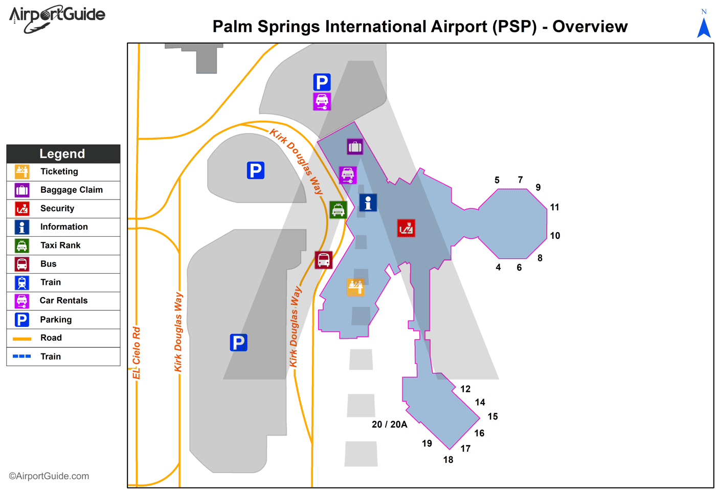
Maps & Diagrams
PSP Sectional
Flight Planning
at skyvector.com
at skyvector.com
 Diagram")