Location
Latitude: |
47-54-26.3450N (47.907318) |
Longitude: |
122-16-55.5380W (-122.282094) |
Elevation: |
606.9 feet MSL (185 m MSL) |
Magnetic Variation: |
15.3 E (as of April 2024 from WMM2020 model) |
Time Zone: |
UTC -8.0 (Standard Time) UTC -7.0 (Daylight Savings Time) |
From City: |
06 N.M. SW of Everett, Washington |
Found On: |
Seattle Chart |
FAA Region: |
ANM |
Contacts
Manager: |
Publicly owned: |
| JOSHUA MARCY 3220 100TH ST SW EVERETT, WA 98204 425-308-2347 |
SNOHOMISH COUNTY 3000 ROCKEFELLER AVE. EVERETT, WA 98201 425-388-5110 |
Operations
Airport Status: |
Operational |
Facility Use: |
Public |
Type: |
Airport |
Activation Date: |
11/1938 |
Control tower: |
Yes |
Attendance (Months/Days/Hours): |
Months/Days/Hours NOV-APR/ALL/0700-2100 |
Boundary ARTCC: |
ZSE (Seattle) |
Responsible ARTCC: |
ZSE (Seattle) |
Lighting Schedule: |
SEE RMK |
Segmented Circle Indicator: |
Yes |
Traffic Pattern Altitude (MSL): |
1607 feet (490 m) |
NOTAMs Facility: |
PAE |
NOTAM-D Service: |
Yes |
International Airport of Entry: |
No |
Customs Landing Rights: |
Yes |
Military Landing Rights: |
Yes |
Civil/Military Joint Use: |
No |
Aircraft Rescue and Firefighting: |
Class I ARFF Index: B Air Carrier Service: Scheduled Certification Date: 11/1974 |
Based Aircraft
| Single Engine: | 478 |
| Multi Engine: | 52 |
| Jet Engine: | 18 |
| GA Helicopters: | 4 |
| Ultralights: | 1 |
Annual Operations (as of 12/31/2018)
| Total Operations: | 115201 | |
| Commercial: | 2917 | 2.5% |
| Air Taxi: | 1091 | 0.9% |
| GA Local: | 56589 | 49.1% |
| GA Itinerant: | 53908 | 46.8% |
| Military Aircraft: | 696 | 0.6% |
Communications
| CTAF: | 132.950 |
| Unicom: | 122.950 |
| Tower: | PAINE 120.2 ;RWY 16L/34R 132.95 ;RWY 16R/34L 256.7 Hrs: 0700-2100 |
| Clearance Del.: | 127.175 |
| Ground: | 121.8 339.8 |
| Approach: | SEATTLE |
| Departure: | SEATTLE |
| ATIS: | 128.65 Hrs: 24 |
| ASOS: | (425-355-6192) |
| AR OPS: | 34.1FM |
- FREQ 121.5 NOT AVBL.
Fixed Based Operators (FBOs) & Fuel
(Click on a business for detail)
Please help us keep this information up to date. This is a FREE SERVICE just like everything else on Airport Guide! If you see that a business needs to be added, modified, or deleted please fill out our Update Form.
To add, modify, or delete a business click here.
Please help us keep this information up to date. This is a FREE SERVICE just like everything else on Airport Guide! If you see that a business needs to be added, modified, or deleted please fill out our Update Form.
Area Code: 425 |
| Business Name | Frequency | Phone | Fuel Grade |
|---|---|---|---|
| ATP
Update FBO info |
348-4672 | ||
| Cannon Aircraft Interiors
Update FBO info |
348-6924 | ||
| Crown Aviation
Update FBO info |
355-4088 | ||
| Fliteline Services, Inc.
Update FBO info |
Unicom 122.95 | 355-6600 | 100LL, Jet A |
| Geneva Aviation
Update FBO info |
353-7400 | ||
| Juliet Fox Aviation
Update FBO info |
355-3511 | ||
| Million Air Northwest
Update FBO info |
Unicom 122.95 | 513-1374 | 100ll Jet A |
| Museum of Flight Restoration
Update FBO info |
745-5150 | ||
| Northway Aviation
Update FBO info |
742-7003 | ||
| Regal Air
Update FBO info |
Unicom 123.3 | 743-9123 | 100LL |
| Sunquest Air Specialities
Update FBO info |
355-4516 |
Flight Service Stations
| Primary | Alternate | |
| FSS on Field: | N | |
| FSS Name (ID): | Seattle(SEA) | |
| Frequency: | ||
| Toll Free Phone: | 1-800-WX-BRIEF |
Instrument Procedures / Charts
FAA Terminal Procedures valid from 0901Z 03/21/24 to 0901Z 04/18/24.
There are various types of charts available for an airport. They are listed in the Page Type column. Here is a legend for those types:
APD - Airport Diagram
DP - Departure Procedure Charts
HOT - Hot Spots
IAP - Instrument Approach Procedure Charts
MIN - Minimums
STAR - Standard Terminal Arrival Charts
| Page Type | Page Name | Volume | Action Since Last Cycle |
|---|---|---|---|
| APD | AIRPORT DIAGRAM | NW-1 | |
| DP | PAINE SIX | NW-1 | |
| HOT | HOT SPOT | NW-1 | |
| IAP | ILS Y OR LOC Y RWY 16R | NW-1 | |
| IAP | ILS Z OR LOC Z RWY 16R | NW-1 | |
| IAP | ILS Z RWY 16R (SA CAT II) | NW-1 | |
| IAP | RNAV (GPS) RWY 34L | NW-1 | |
| IAP | RNAV (GPS) Y RWY 16R | NW-1 | |
| IAP | RNAV (GPS) Z RWY 16R | NW-1 | |
| IAP | VOR-A | NW-1 | |
| MIN | ALTERNATE MINIMUMS | NW-1 | |
| MIN | DIVERSE VECTOR AREA | NW-1 | |
| MIN | TAKEOFF MINIMUMS | NW-1 | |
| STAR | CHINS FIVE | NW-1 | |
| STAR | CHINS FIVE[DELIMITER] CONT.1 | NW-1 | |
| STAR | DEVYN TWO (RNAV) | NW-1 | |
| STAR | OLYMPIA TWO | NW-1 | |
| STAR | OLYMPIA TWO[DELIMITER] CONT.1 | NW-1 |
Terminal Procedures are only available for airports in several countries with more being added all the time. If you are looking for a specific country's charts, please send an email to support(at)airportguide.com stating the country name. This will be used to prioritize the implementation.
Navigation Aids (Navaids) near PAE
| Dist (NM) | ID | Morse Code | Name | Type | Freq | True Hdg | Mag Hdg |
|---|---|---|---|---|---|---|---|
| 0.8 | PAE | . _ _ . . _ . | Paine | VOR-DME | 110.60 | 12 | 357 |
| 11.4 | AW | . _ . _ _ | Waton | NDB | 382 | 26 | 11 |
| 17.1 | BF | _ . . . . . _ . | Nolla | NDB | 362 | 194 | 179 |
| 22.5 | HPK | . . . . . _ _ . _ . _ | Parkk | NDB | 281 | 182 | 167 |
| 22.7 | BFI | _ . . . . . _ . . . | Seattle | VOT | 108.60 | 182 | 167 |
| 24.9 | RNT | . _ . _ . _ | Renton | NDB | 353 | 173 | 158 |
| 26.9 | CVV | _ . _ . . . . _ . . . _ | Penn Cove | VOR-DME | 117.20 | 318 | 303 |
| 27.1 | SEA | . . . . . _ | Seattle-Tacoma | VOT | 117.50 | 181 | 166 |
| 28.3 | SEA | . . . . . _ | Seattle | VORTAC | 116.80 | 182 | 167 |
| 30.9 | NUW | _ . . . _ . _ _ | Whidbey Island | TACAN | 113.80 | 330 | 315 |
| 31.4 | PWT | . _ _ . . _ _ _ | Kitsap | NDB | 206 | 217 | 202 |
| 34.1 | BVS | _ . . . . . . _ . . . | Skagit/Bay View | NDB | 240 | 350 | 335 |
| 37.3 | CAN | _ . _ . . _ _ . | Carney | NDB | 274 | 217 | 202 |
| 42.8 | OPZ | _ _ _ . _ _ . _ _ . . | Lopez Island | NDB | 356 | 323 | 308 |
| 46.2 | TCM | _ _ . _ . _ _ | Mcchord | TACAN | 109.60 | 189 | 174 |
| 46.9 | FHR | . . _ . . . . . . _ . | Friday Harbor | NDB | 284 | 321 | 306 |
| 47.1 | NOW | _ . _ _ _ . _ _ | Ediz Hook | NDB | 338 | 287 | 272 |
| 47.3 | GRF | _ _ . . _ . . . _ . | Graye | NDB | 216 | 196 | 181 |
| 51.2 | MNC | _ _ _ . _ . _ . | Mason County | NDB | 348 | 219 | 204 |
| 55.1 | LAC | . _ . . . _ _ . _ . | Lacomas | NDB | 328 | 191 | 176 |
Nearby Airports with Fuel
Notices to Airmen (NOTAMS)
Remarks
| A110-1 | RWY 16L/34R CLSD BTN 0500-1500Z. |
| A110-11 | AVOID INT DEPS FM RWY 16L/34R |
| A110-12 | FLOCKS OF LRG & SML BIRDS INVOF ARPT. |
| A110-15 | ITNRNT DEP OF SML ACFT OVER 250 HORSEPOWER ON RWY 34R. |
| A110-16 | TWY A-2 RSTRD TO 30000 LBS. |
| A110-17 | AREAS NOT VSB FM ATCT INCL E EDGE OF S 1200 FT OF TWY A, TAXILANE E FM SE CORNER OF W HNGRS TO TWY A, TAXILANE H FROM NW EDGE OF W HNGRS TO TAXILANE E. |
| A110-18 | RWY 16L/34R LTD TO HEL 8000 LBS OR LESS. |
| A110-24 | FOR NOISE ABATEMENT FROM 0500-1500Z++ IF ACFT PERFORMANCE/WIND ALLOWS, USE RY 16R FOR ARRIVALS AND RY 34L FOR DEPARTURES. |
| A110-25 | TAXILANE E RSTD TO WINGSPAN LESS THAN 171 FT. ACFT WINGSPAN OF 171 FT OR GREATER ON TAXILANE E, TUG OPS ONLY. EAST 500 FT OF TAXILANE E RSTD TO WINGSPAN LESS THAN 49 FT. |
| A110-27 | TWY C BTN TRML RAMP AND CNTRL RAMP RSTRD TO WINGSPAN OF 68 FT OR LESS. TWY D, F, G AND L RSTRD TO WINGSPAN LESS THAN 49 FT. TWY A4, A5, K7 & B RSTRD TO WINGSPAN LESS THAN 118 FT. TAXILANE H RSTRD TO WINGSPAN LESS THAN 49 FT. |
| A110-28 | PAE HAS FAC CONSTRAINTS THAT LMT ITS ABILITY TO ACCOMMODATE DIVD FLTS AND MNTN THE ARPTS SAFE OPN DUR IREG OPS. ACFT OPR SHOULD CTCT THE ON-DUTY ARPT OPS PSNL (425-388-5125) TO COORD DIVD FLTS EXC IN THE CASE OF A DECLARED IN-FLT EMERG. |
| A110-29 | PPR RQRD FOR ACES ON BOEING RAMP. CTC BOEING FLT DISPATCH 206-544-5900 FOR APVL. PRIOR TO TAXI ONTO BOEING RAMP CTC BOEING RADIO TWR 123.475 OR CALL 425-342-5900. |
| A110-3 | NOISE SENSITIVE ARPT; FOR NOISE ABATEMENT PROC & TFC PROC CALL ARPT OPS 425-388-5125. |
| A110-30 | TWY K1 CLSD TO ACFT UNDER 30000 LBS. |
| A110-31 | TSNT HEL EXP LNDG/TKOF ON TWY B. |
| A110-32 | AIRFIELD CONDS NOT MNTD BTN 0000-0600. |
| A110-33 | EMERG FREQ 121.5 NOT MNT AT TWR. SEATTLE APP CON-TRACON MNT 121.5 FOR EVERETT (PAE). |
| A110-34 | FOR CD WHEN ATCT IS CLSD CTC SEATTLE APCH AT 206-214-4722. |
| A110-35 | TKOF CLNC RWY 16R FULL LEN; ENT RWY VIA TWY A1 UNLESS TWY AA SPECIFIED. |
| A110-36 | LRG ACFT FLY W PAT OVR WTR; SML ACFT FLY E PAT OVR ARPT. |
| A110-37 | USE CTN FOR 80 FT AGL LGT POLES SW EDGE OF BRAVO RAMP. |
| A110-38 | RWY 16R/34 TGL PROHIBITED MON-FRI FM 0700-0900. |
| A110-5 | IT IS REQ THAT PILOTS ADHERE TO THE FLW NOISE ABATEMENT PROC UNLESS OTRW INSTRD BY ATCT, ITNRNT ARR AND LOW APCH OF SML ACFT OVER 250 HORSEPOWER AUZ ON RWYS 16L AND 34R. |
| A110-6 | BE ALERT TO CNVG TFC ON BASE TO FINAL LEGS RWY 16R/34L 2100-0700. |
| A110-7 | AVOID LOW LVL OVRFLT OF BOEING RAMP; NE CORNER OF ARPT DUE TO JET BLAST. |
| A110-8 | TRNG FLTS DISCOURAGED AFT 2200. |
| A24 | LNDG FEE FOR ACFT OVER 30000 LBS GWT. |
| A26 | ARPT CLSD TO UNSKED ACR OPNS WITH MORE THAN 30 PSGR SEATS 2100-0700 EXCP PPR CTC ARPT OPS 425-388-5125. |
| A33-16R/34L | RY 16R/34L FIRST 1000 FT OF RY 16R IS CONCRETE. |
| A70-FUEL-10 | 0LL 100LL SELF SVC AVBL 24 HRS WITH CREDIT CARD AT CNTRL RAMP. HEL ARE PROHIBITED AT THE SELF SVC FUELING IS. FOR JET AND HEL FUEL AFT HRS CALL 425-355-6600. |
| A81-APT | WHEN ATCT CLSD ACTVT HIRL RY 16R/34L, MALSR RY 16R, & PAPI RY 34L - CTAF. |
| E111 | ESTABD PRIOR TO 15 MAY 1959. |
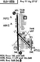
Runways
Runway Summary
| Runways: | 16L/34R 16R/34L |
| Longest Runway: | 16R/34L is 9010 ft (2746 m) long |
| Runways with an Instrument Approach: | 16R |
PAE Airport Runway Details
| Runway 16L/34R | 3004 ft x 75 ft (916 m x 23 m) | |
| Runway Length Source: | 3RD PARTY SURVEY as of 10/21/2020 | |
| Surface: | Asphalt - Good condition - No special surface treatment | |
| Runway Pavement Class: | 4 /F/B/Y/T | |
| Runway Edge Lights: | Medium Intensity | |
Runway Weight Bearing Capacity (in thousands of pounds) |
||
| Single Wheel Landing Gear: | 12.5 | |
Runway 16L |
Runway 34R |
|
Elevation: |
602.9 | 599.8 |
Latitude: |
47-54-23.1290N | 47-53-53.4898N |
Longitude: |
122-16-18.0936W | 122-16-17.7647W |
|
Runway True Alignment: |
180 | 360 |
Glide Path Angle: |
3.2 degrees | 3.0 degrees |
Traffic Pattern: |
Right | |
Runway Markings Type: |
Basic | Basic |
Runway Markings Condition: |
Good | Good |
Object at End: |
POLE | POLE |
Object Height: |
9 | 25 |
Distance from End: |
400 | 690 |
Object Centerline Offset: |
100 ft. left of centerline | 125 ft. left of centerline |
Visual Glide Slope Indicators: |
2-Light PAPI On Left Side Of Runway | 2-Light PAPI On Left Side Of Runway |
REIL: |
Yes | Yes |
Threshold Crossing Height: |
24 | 22 |
Declared Distances |
||
Take Off Run Avbl. (TORA): |
3004 | 3004 |
Take Off Distance Avbl. (TODA): |
3004 | 3004 |
Actual Stop Dist. Avbl. (ASDA): |
3004 | 3004 |
Landing Dist. Avbl. (LDA): |
3004 | 3004 |
| Runway 16R/34L | 9010 ft x 150 ft (2746 m x 46 m) | |
| Runway Length Source: | 3RD PARTY SURVEY as of 10/21/2020 | |
| Surface: | Asphalt - Good condition - Saw-cut or plastic grooved | |
| Runway Pavement Class: | 83 /F/A/W/T | |
| Runway Edge Lights: | High Intensity | |
Runway Weight Bearing Capacity (in thousands of pounds) |
||
| Single Wheel Landing Gear: | 100.0 | |
| Dual Wheel Landing Gear: | 200.0 | |
| Dual Tandem Wheel Landing Gear: | 350.0 | |
| Dual Dual Tandem Wheel Landing Gear: | 830.0 | |
Runway 16R |
Runway 34L |
|
Elevation: |
562.7 | 577.6 |
Latitude: |
47-55-16.8088N | 47-53-47.9040N |
Longitude: |
122-17-09.0632W | 122-17-07.0916W |
|
Runway True Alignment: |
179 | 359 |
ILS Type: |
ILS | |
Glide Path Angle: |
3.0 degrees | 3.0 degrees |
Traffic Pattern: |
Right | |
Runway Markings Type: |
Precision Instrument | Nonprecision Instrument |
Runway Markings Condition: |
Good | Good |
Object at End: |
TREES | |
Object Height: |
125 | |
Distance from End: |
4000 | |
Object Centerline Offset: |
100 ft. left of centerline | 125 ft. left of centerline |
Visual Glide Slope Indicators: |
4-Light PAPI On Right Side Of Runway | 4-Light PAPI On Left Side Of Runway |
Runway Visual Range (RVR): |
Touchdown, Rollout | Touchdown, Rollout |
Approach Light System: |
1,400 Foot Medium Intensity Approach Lighting System With Runway Alignment Indicator Lights | 1,400 Foot Medium Intensity Approach Lighting System With Sequenced Flashers |
Touchdown Lights: |
Yes | |
Centerline Lights: |
Yes | Yes |
Threshold Crossing Height: |
74 | 75 |
Declared Distances |
||
Take Off Run Avbl. (TORA): |
9010 | 9010 |
Take Off Distance Avbl. (TODA): |
9010 | 9010 |
Actual Stop Dist. Avbl. (ASDA): |
9010 | 9010 |
Landing Dist. Avbl. (LDA): |
9010 | 9010 |
Services
Airframe Repair: |
Major |
Powerplant Repair: |
Major |
Bottled Oxygen: |
None |
Bulk Oxygen: |
None |
Fuel Available: |
100LL, Jet A |
Landing Fees: |
No |
Parking: |
Tiedowns available |
Other Services: |
Glider instruction and rental, parachute rental |
Maps & Diagrams
PAE Sectional
Flight Planning
at skyvector.com
at skyvector.com