Location
Latitude: |
33-17-55.5760N (33.298771) |
Longitude: |
111-54-56.8350W (-111.915788) |
Elevation: |
1178.5 feet MSL (359 m MSL) |
Magnetic Variation: |
9.7 E (as of April 2024 from WMM2020 model) |
Time Zone: |
UTC -7.0 (Standard Time) UTC -7.0 (Daylight Savings Time) |
From City: |
03 N.M. W of Chandler, Arizona |
Found On: |
Phoenix Chart |
FAA Region: |
AWP |
Contacts
Manager: |
Privately owned: |
| BOD, STELLAR RUNWAY UTILIZERS ASSN 11 NORTH STELLAR PARKWAY CHANDLER, AZ 85226-3715 480-295-2683 |
STELLAR RUNWAY UTILIZERS ASSN, INC. 11 NORTH STELLAR PARKWAY CHANDLER, AZ 85226 480-295-2683 |
Operations
Airport Status: |
Operational |
Facility Use: |
Public |
Type: |
Airport |
Control tower: |
No |
Attendance (Months/Days/Hours): |
Months/Days/Hours Unattended |
Boundary ARTCC: |
ZAB (Albuquerque) |
Responsible ARTCC: |
ZAB (Albuquerque) |
Lighting Schedule: |
SEE RMK |
Segmented Circle Indicator: |
No |
Traffic Pattern Altitude (MSL): |
2178 feet (664 m) |
NOTAMs Facility: |
PRC |
NOTAM-D Service: |
Yes |
International Airport of Entry: |
No |
Customs Landing Rights: |
No |
Based Aircraft
| Single Engine: | 119 |
| Multi Engine: | 4 |
| Jet Engine: | 10 |
| GA Helicopters: | 4 |
| Gliders: | 1 |
| Ultralights: | 3 |
Annual Operations (as of 04/14/2021)
| Total Operations: | 40000 | |
| GA Local: | 32000 | 80.0% |
| GA Itinerant: | 8000 | 20.0% |
Communications
| CTAF: | 122.975 |
| Unicom: | 122.975 |
| Approach: | PHOENIX 123.7 123.7 123.7 123.7 |
| Departure: | PHOENIX 123.7 123.7 123.7 123.7 |
Fixed Based Operators (FBOs) & Fuel
(Click on a business for detail)
Please help us keep this information up to date. This is a FREE SERVICE just like everything else on Airport Guide! If you see that a business needs to be added, modified, or deleted please fill out our Update Form.
To add, modify, or delete a business click here.
Please help us keep this information up to date. This is a FREE SERVICE just like everything else on Airport Guide! If you see that a business needs to be added, modified, or deleted please fill out our Update Form.
Area Code: 480 |
| Business Name | Frequency | Phone | Fuel Grade |
|---|---|---|---|
| Stellar Aviation
Update FBO info |
Unicom 122.8 | 961-9050 | 100LL, Jeta |
Flight Service Stations
| Primary | Alternate | |
| FSS on Field: | N | |
| FSS Name (ID): | Prescott(PRC) | |
| Frequency: | ||
| Toll Free Phone: | 1-800-WX-BRIEF |
Instrument Procedures / Charts
FAA Terminal Procedures valid from 0901Z 03/21/24 to 0901Z 04/18/24.
There are various types of charts available for an airport. They are listed in the Page Type column. Here is a legend for those types:
APD - Airport Diagram
DP - Departure Procedure Charts
HOT - Hot Spots
IAP - Instrument Approach Procedure Charts
MIN - Minimums
STAR - Standard Terminal Arrival Charts
| Page Type | Page Name | Volume | Action Since Last Cycle |
|---|---|---|---|
| DP | JEWLZ ONE (RNAV) | SW-4 | |
| IAP | RNAV (GPS) RWY 35 | SW-4 | Changed |
| MIN | TAKEOFF MINIMUMS | SW-4 | |
| STAR | ARLIN FOUR | SW-4 | |
| STAR | BLYTHE FIVE | SW-4 | |
| STAR | SUNSS EIGHT | SW-4 |
Terminal Procedures are only available for airports in several countries with more being added all the time. If you are looking for a specific country's charts, please send an email to support(at)airportguide.com stating the country name. This will be used to prioritize the implementation.
Navigation Aids (Navaids) near P19
| Dist (NM) | ID | Morse Code | Name | Type | Freq | True Hdg | Mag Hdg |
|---|---|---|---|---|---|---|---|
| 5.7 | CHD | _ . _ . . . . . _ . . | Chandler | NDB | 407 | 109 | 99 |
| 8.5 | PXR | . _ _ . _ . . _ . _ . | Phoenix | VORTAC | 115.60 | 341 | 331 |
| 9.4 | PHX | . _ _ . . . . . _ . . _ | Phoenix | VOT | 109.00 | 330 | 320 |
| 13.3 | IWA | . . . _ _ . _ | Willie | VORTAC | 113.30 | 88 | 78 |
| 13.4 | FFZ | . . _ . . . _ . _ _ . . | Falcon Field | NDB | 281 | 43 | 33 |
| 24.8 | TFD | _ . . _ . _ . . | Stanfield | VORTAC | 114.80 | 179 | 169 |
| 27.3 | LUF | . _ . . . . _ . . _ . | Luke | TACAN | 113.00 | 301 | 291 |
| 43.3 | GBN | _ _ . _ . . . _ . | Gila Bend | VORTAC | 116.60 | 241 | 231 |
| 46.5 | BXK | _ . . . _ . . _ _ . _ | Buckeye | VORTAC | 110.60 | 281 | 271 |
| 63.9 | AVQ | . _ . . . _ _ _ . _ | Marana | NDB | 245 | 146 | 137 |
| 64.2 | PAN | . _ _ . . _ _ . | Payson | DME | 116.35 | 26 | 16 |
| 78.6 | RBJ | . _ . _ . . . . _ _ _ | Robles | NDB | 220 | 158 | 149 |
| 79.3 | RYN | . _ . _ . _ _ _ . | Ryan | NDB | 338 | 151 | 142 |
| 85.0 | PRC | . _ _ . . _ . _ . _ . | Prescott | VOT | 110.00 | 342 | 332 |
| 86.0 | DMA | _ . . _ _ . _ | Davis Monthan | TACAN | 117.60 | 142 | 133 |
| 88.1 | TUS | _ . . _ . . . | Tucson | VORTAC | 116.00 | 144 | 135 |
| 88.8 | DRK | _ . . . _ . _ . _ | Drake | VORTAC | 114.10 | 341 | 331 |
Nearby Airports with Fuel
Notices to Airmen (NOTAMS)
Remarks
| A110-1 | ALERT: NON RADIO ACFT & BIRDS ON & INVOF ARPT. |
| A110-11 | TSNT CRTFYD FOR 15000 GROSS TKOF WEIGHT PPR. |
| A110-12 | FOR CD CTC PHOENIX APCH AT 602-306-2565. |
| A110-2 | TRNG TGL & TRNG HEL NA. |
| A110-4 | AVOID OTFC OF NOISE SENS AREA W OF RWY 17/35 & N OF ARPT. |
| A110-5 | COML & STUDENT TRNG OPS PMT ONLY. |
| A110-8 | FLOOD IRRIGATION BTW RWY & TWY; WATER UP TO 1 FT IREG SKED. |
| A110-9 | ENG RUNUP USE E SIDE AREA. |
| A30-17/35 | RWY 17 CALM WIND RWY. |
| A57-17 | 34:1 APCH 34:1 TO DTHR; 21 FT TREE 725 FT FM DTHR 100 FT L OF CNTRLN. |
| A57-35 | APCH SLOPE 22:1 TO DTHR. |
| A58-17 | +8 FT FENCE 130 FT FM RWY END; +15 FT ROAD 164 FT FM RWY END ACRS THR. |
| A58-35 | +6 FT FENCE 80 FT FM RWY END ACRS THR; +15 FT ROAD 85 FT FM RWY END ACRS THR. |
| A70-FUEL-10 | 0LL FUEL INFO - 602-793-6383. |
| A81-APT | DUSK-DAWN: ACTVT REIL RWY 17 & 35; MIRL RWY 17/35 - CTAF. |
| E111 | TFC PAT TO W OF ARPT. |
Runways
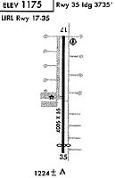
Runway Summary
| Runways: | 17/35 |
| Longest Runway: | 17/35 is 4417 ft (1346 m) long |
| Runways with an Instrument Approach: |
P19 Airport Runway Details
| Runway 17/35 | 4417 ft x 80 ft (1346 m x 24 m) | |
| Runway Length Source: | 3RD PARTY SURVEY as of 08/04/2019 | |
| Surface: | Asphalt - Good condition - No special surface treatment | |
| Runway Edge Lights: | Medium Intensity | |
Runway 17 |
Runway 35 |
|
Elevation: |
1178.0 | 1173.7 |
Latitude: |
33-18-17.4234N | 33-17-33.7290N |
Longitude: |
111-54-56.8165W | 111-54-56.8540W |
|
Runway True Alignment: |
180 | 000 |
Glide Path Angle: |
3.2 degrees | 3.2 degrees |
Traffic Pattern: |
Left | Left |
Runway Markings Type: |
Nonprecision Instrument | Nonprecision Instrument |
Runway Markings Condition: |
Good | Good |
Object at End: |
ROAD | TREE |
Object Height: |
15 | 12 |
Distance from End: |
201 | 210 |
Object Centerline Offset: |
0 ft. left and right of centerline | 110 ft. left of centerline |
Visual Glide Slope Indicators: |
2-Light PAPI On Left Side Of Runway | 2-Light PAPI On Right Side Of Runway |
REIL: |
Yes | Yes |
Touchdown Lights: |
No | No |
Centerline Lights: |
No | No |
Threshold Crossing Height: |
39 | 40 |
Threshold Elevation: |
1178.3 | 1174.0 |
Displaced Threshold: |
366 | 349 |
Threshold Latitude: |
33-18-13.8001N | 33-17-37.1779N |
Threshold Longitude: |
111-54-56.8200W | 111-54-56.8514W |
Declared Distances |
||
Landing Dist. Avbl. (LDA): |
4051 | 4068 |
Services
Fuel Available: |
100LL |
Landing Fees: |
No |
Parking: |
Tiedowns available |
Other Services: |
Fuel for emergency only |
Maps & Diagrams
P19 Sectional
Flight Planning
at skyvector.com
at skyvector.com