Location
Latitude: |
34-01-20.9000N (34.022472) |
Longitude: |
106-54-11.3000W (-106.903139) |
Elevation: |
4875.2 feet MSL (1486 m MSL) |
Magnetic Variation: |
7.9 E (as of April 2024 from WMM2020 model) |
Time Zone: |
UTC -7.0 (Standard Time) UTC -6.0 (Daylight Savings Time) |
From City: |
03 N.M. S of Socorro, New Mexico |
Found On: |
Albuquerque Chart |
FAA Region: |
ASW |
Contacts
Manager: |
Publicly owned: |
| ISAAC ANGEL PO BOX K SOCORRO, NM 87801 505-507-2800 |
CITY OF SOCORRO PO BOX K SOCORRO, NM 87801 575-835-2490 |
Operations
Airport Status: |
Operational |
Facility Use: |
Public |
Type: |
Airport |
Activation Date: |
04/1940 |
Control tower: |
No |
Attendance (Months/Days/Hours): |
Months/Days/Hours Unattended |
Boundary ARTCC: |
ZAB (Albuquerque) |
Responsible ARTCC: |
ZAB (Albuquerque) |
Lighting Schedule: |
SEE RMK |
Segmented Circle Indicator: |
Yes |
Traffic Pattern Altitude (MSL): |
5875 feet (1791 m) |
NOTAMs Facility: |
ABQ |
NOTAM-D Service: |
Yes |
International Airport of Entry: |
No |
Customs Landing Rights: |
No |
Military Landing Rights: |
Yes |
Civil/Military Joint Use: |
No |
Based Aircraft
| Single Engine: | 14 |
Annual Operations (as of 04/03/2023)
| Total Operations: | 5000 | |
| GA Local: | 2500 | 50.0% |
| GA Itinerant: | 2400 | 48.0% |
| Military Aircraft: | 100 | 2.0% |
Communications
| CTAF: | 122.800 |
| Unicom: | 122.800 |
| AWOS-3: | 118.325 (575-838-3993) |
- APCH/DEP SVC PRVDD BY ALBUQUERQUE ARTCC (ZAB) ON FREQS 124.325/288.25 (ZUNI RCAG).
Fixed Based Operators (FBOs) & Fuel
(Click on a business for detail)
Please help us keep this information up to date. This is a FREE SERVICE just like everything else on Airport Guide! If you see that a business needs to be added, modified, or deleted please fill out our Update Form.
To add, modify, or delete a business click here.
Please help us keep this information up to date. This is a FREE SERVICE just like everything else on Airport Guide! If you see that a business needs to be added, modified, or deleted please fill out our Update Form.
Area Code: 505 |
| Business Name | Frequency | Phone | Fuel Grade |
|---|---|---|---|
| City of Socorro
Update FBO info |
Unicom 122.8 | 835-1953, 835-3582 on call | 100LL |
| Socorro Air Taxi, Inc.
Update FBO info |
835-3582 |
Flight Service Stations
| Primary | Alternate | |
| FSS on Field: | N | |
| FSS Name (ID): | Albuquerque(ABQ) | |
| Frequency: | ||
| Toll Free Phone: | 1-800-WX-BRIEF |
Instrument Procedures / Charts
FAA Terminal Procedures valid from 0901Z 03/21/24 to 0901Z 04/18/24.
There are various types of charts available for an airport. They are listed in the Page Type column. Here is a legend for those types:
APD - Airport Diagram
DP - Departure Procedure Charts
HOT - Hot Spots
IAP - Instrument Approach Procedure Charts
MIN - Minimums
STAR - Standard Terminal Arrival Charts
| Page Type | Page Name | Volume | Action Since Last Cycle |
|---|---|---|---|
| IAP | RNAV (GPS) RWY 33 | SW-1 | |
| IAP | VOR/DME-A | SW-1 | |
| MIN | TAKEOFF MINIMUMS | SW-1 |
Terminal Procedures are only available for airports in several countries with more being added all the time. If you are looking for a specific country's charts, please send an email to support(at)airportguide.com stating the country name. This will be used to prioritize the implementation.
Navigation Aids (Navaids) near ONM
| Dist (NM) | ID | Morse Code | Name | Type | Freq | True Hdg | Mag Hdg |
|---|---|---|---|---|---|---|---|
| 19.4 | ONM | _ _ _ _ . _ _ | Socorro | VORTAC | 116.80 | 12 | 4 |
| 37.8 | BRG | _ . . . . _ . _ _ . | Belen | DME | 114.75 | 5 | 357 |
| 48.2 | TCS | _ _ . _ . . . . | Truth Or Consequences | VORTAC | 112.70 | 203 | 195 |
| 61.4 | ABQ | . _ _ . . . _ _ . _ | Albuquerque | VORTAC | 113.20 | 3 | 355 |
| 62.7 | ABQ | . _ _ . . . _ _ . _ | Albuquerque | VOT | 111.00 | 13 | 5 |
| 64.2 | CNX | _ . _ . _ . _ . . _ | Corona | VORTAC | 115.50 | 70 | 62 |
| 72.3 | AE | . _ . | Dudle | NDB | 351 | 7 | 359 |
| 79.1 | OTO | _ _ _ _ _ _ _ | Otto | VOR | 114.00 | 36 | 28 |
| 80.2 | HMN | . . . . _ _ _ . | Holloman | TACAN | 114.50 | 150 | 142 |
| 81.3 | CEP | _ . _ . . . _ _ . | Capitan | NDB | 278 | 112 | 104 |
| 84.7 | BWS | _ . . . . _ _ . . . | Boles | DME | 113.65 | 148 | 140 |
| 99.4 | SG | . . . _ _ . | Doman | NDB | 341 | 22 | 14 |
Nearby Airports with Fuel
| Dist (NM) | Name (Airport IDs) | True Hdg | Mag Hdg | Fuel Grade |
|---|---|---|---|---|
| 37.5 | Belen Regional Airport (BRG) |
5 | 357 | 100LL, Jet A-1+ |
| 45.0 | Mid Valley Airpark Airport (E98) |
9 | 1 | 100LL |
| 50.7 | Truth Or Consequences Municipal Airport (TCS KTCS TCS) |
201 | 193 | 100LL, Jet A-1+ |
| 55.0 | Carrizozo Municipal Airport (F37) |
113 | 106 | 100LL |
| 62.7 | Albuquerque International Sunport Airport (ABQ KABQ ABQ) |
13 | 5 | 100LL, Jet A, Jet A-1, Jet A-1+ |
| 67.6 | Double Eagle Ii Airport (KAEG AEG) |
4 | 356 | 100LL, Jet A-1 |
| 72.7 | Moriarty Municipal Airport (0E0) |
37 | 29 | 100LL, Jet A |
| 74.0 | Sandia Airpark Estates East Airport (1N1) |
29 | 21 | 100LL |
| 76.3 | Sierra Blanca Regional Airport (RUI KSRR SRR) |
115 | 108 | 100LL, Jet A |
| 84.4 | Alamogordo-White Sands Regional Airport (ALM KALM ALM) |
146 | 139 | 100LL, Jet A-1+ |
| 84.6 | Grants-Milan Municipal Airport (GNT KGNT GNT) |
324 | 316 | 100LL, Jet A-1+ |
| 100.0 | Whiskey Creek Airport (94E) |
221 | 213 | 100LL, Jet A |
Notices to Airmen (NOTAMS)
Remarks
| A110*G | THIS AIRPORT HAS BEEN SURVEYED BY THE NATIONAL GEODETIC SURVEY. |
| A110-1 | GATE CODE 4850. |
| A110-4 | FOR CD CTC ALBUQUERQUE ARTCC AT 505-856-4561. |
| A17 | EMERG - 505-507-2800. |
| A30-06/24 | 4-8 FT BRUSH IN PRIM SFC 50-125 FT FM CNTRLN S SIDE & 60-125 FT FM CNTRLN N SIDE. |
| A30-15/33 | +4-7 FT BRUSH IN PRIM SFC 70-250 FT FM CNTRLN W SIDE & S OF RWY 06/24. |
| A30A-15 | -40 FT DROP OFF 175 FT FM THR BOTH SIDES. |
| A30A-33 | -20 FT DROP OFF 100 FT FM THR BOTH SIDES. |
| A57-15 | 50:1 TO DTHR. |
| A57-33 | 0:1 TO DTHR DUE TO 3-4 FT BRUSH 120-250 FT L OF CNTRLN AT DTHR. |
| A58-15 | 1-3FT BRUSH 20-80 FT FM THR BOTH SIDES; 3 FT FENCE 80 FT FM THR 60 FT L OF CNTRLN. |
| A58-33 | 1-2 FT BRUSH 20-100 FT FM THR L & R OF CNTRLN. |
| A70-FUEL-10 | 0LL AVBL H24 WITH CREDIT CARD. |
| A81-APT | ACTVT PAPI RWY 15; PAPI RWY 33; MIRL RWY 06/24 & 15/33 - CTAF. MIRL RWY 15/33 PRESET LOW INTST; INCR INTST - CTAF. |
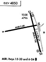
Runways
Runway Summary
| Runways: | 06/24 15/33 |
| Longest Runway: | 15/33 is 5841 ft (1780 m) long |
| Runways with an Instrument Approach: |
ONM Airport Runway Details
| Runway 06/24 | 4590 ft x 60 ft (1399 m x 18 m) | |
| Runway Length Source: | NGS as of 04/28/1997 | |
| Surface: | Asphalt - Good condition - No special surface treatment | |
| Runway Pavement Class: | 3 /F/D/Y/T | |
| Runway Edge Lights: | Medium Intensity | |
Runway 06 |
Runway 24 |
|
Elevation: |
4875.2 | 4785.4 |
Latitude: |
34-01-17.9250N | 34-01-30.7980N |
Longitude: |
106-54-51.6820W | 106-53-59.4160W |
|
Runway True Alignment: |
074 | 254 |
Glide Path Angle: |
0.0 degrees | 0.0 degrees |
Runway Markings Type: |
Basic | Basic |
Runway Markings Condition: |
Good | Good |
| Runway 15/33 | 5841 ft x 75 ft (1780 m x 23 m) | |
| Runway Length Source: | NGS as of 04/28/1997 | |
| Surface: | Asphalt - Good condition - No special surface treatment | |
| Runway Pavement Class: | 9 /F/D/Y/T | |
| Runway Edge Lights: | Medium Intensity | |
Runway Weight Bearing Capacity (in thousands of pounds) |
||
| Single Wheel Landing Gear: | 50.0 | |
| Dual Wheel Landing Gear: | 75.0 | |
Runway 15 |
Runway 33 |
|
Elevation: |
4798.5 | 4744.2 |
Latitude: |
34-01-45.8650N | 34-00-50.4720N |
Longitude: |
106-54-09.9390W | 106-53-50.2550W |
|
Runway True Alignment: |
164 | 344 |
Glide Path Angle: |
4.0 degrees | 4.0 degrees |
Traffic Pattern: |
Left | Left |
Runway Markings Type: |
Nonprecision Instrument | Nonprecision Instrument |
Runway Markings Condition: |
Good | Good |
Visual Glide Slope Indicators: |
2-Light PAPI On Left Side Of Runway | 2-Light PAPI On Left Side Of Runway |
Threshold Crossing Height: |
25 | 26 |
Threshold Elevation: |
4798.1 | 4745.8 |
Displaced Threshold: |
186 | 182 |
Threshold Latitude: |
34-01-44.1390N | 34-00-52.1882N |
Threshold Longitude: |
106-54-09.3269W | 106-53-50.8769W |
Services
Airframe Repair: |
Major |
Powerplant Repair: |
Major |
Fuel Available: |
100LL, Jet A |
Landing Fees: |
No |
Parking: |
Hangars and tiedowns available |
Maps & Diagrams
ONM Sectional
Flight Planning
at skyvector.com
at skyvector.com