Location
Latitude: |
40-11-16.4920N (40.187914) |
Longitude: |
077-10-27.3850W (-77.174274) |
Elevation: |
510.1 feet MSL (155 m MSL) |
Magnetic Variation: |
10.9 W (as of April 2024 from WMM2020 model) |
Time Zone: |
UTC -5.0 (Standard Time) UTC -4.0 (Daylight Savings Time) |
From City: |
02 N.M. SE of Carlisle, Pennsylvania |
Found On: |
Detroit Chart |
FAA Region: |
AEA |
Contacts
Manager: |
Publicly owned: |
| JEFF SMITH 228 PETERSBURG RD CARLISLE, PA 17013 717-448-7730 |
SOUTH MIDDLETON TWP 520 PARK DRIVE BOILING SPRINGS, PA 17007 717-258-5324 |
Operations
Airport Status: |
Operational |
Facility Use: |
Public |
Type: |
Airport |
Activation Date: |
03/1963 |
Control tower: |
No |
Attendance (Months/Days/Hours): |
Months/Days/Hours ALL/MON-FRI/0900-1700 |
Boundary ARTCC: |
ZNY (New York) |
Responsible ARTCC: |
ZNY (New York) |
Lighting Schedule: |
SEE RMK |
Segmented Circle Indicator: |
Yes |
Traffic Pattern Altitude (MSL): |
1510 feet (460 m) |
NOTAMs Facility: |
IPT |
NOTAM-D Service: |
Yes |
International Airport of Entry: |
No |
Customs Landing Rights: |
No |
Military Landing Rights: |
No |
Civil/Military Joint Use: |
No |
Based Aircraft
| Single Engine: | 40 |
| Multi Engine: | 4 |
| GA Helicopters: | 2 |
Annual Operations (as of 11/13/2023)
| Total Operations: | 24500 | |
| Air Taxi: | 500 | 2.0% |
| GA Local: | 15000 | 61.2% |
| GA Itinerant: | 8000 | 32.7% |
| Military Aircraft: | 1000 | 4.1% |
Communications
| CTAF: | 122.800 |
| Unicom: | 122.800 |
| Approach: | HARRISBURG 124.1 124.1 |
| Departure: | HARRISBURG 124.1 124.1 |
Fixed Based Operators (FBOs) & Fuel
(Click on a business for detail)
Please help us keep this information up to date. This is a FREE SERVICE just like everything else on Airport Guide! If you see that a business needs to be added, modified, or deleted please fill out our Update Form.
To add, modify, or delete a business click here.
Please help us keep this information up to date. This is a FREE SERVICE just like everything else on Airport Guide! If you see that a business needs to be added, modified, or deleted please fill out our Update Form.
Area Code: 717 |
| Business Name | Frequency | Phone | Fuel Grade |
|---|---|---|---|
| Business Airport of Carlisle, Inc.
Update FBO info |
Unicom 122.8 | 243-2133 | 100LL, Jet A |
Flight Service Stations
| Primary | Alternate | |
| FSS on Field: | N | |
| FSS Name (ID): | Williamsport(IPT) | |
| Frequency: | ||
| Toll Free Phone: | 1-800-WX-BRIEF |
Instrument Procedures / Charts
FAA Terminal Procedures valid from 0901Z 03/21/24 to 0901Z 04/18/24.
There are various types of charts available for an airport. They are listed in the Page Type column. Here is a legend for those types:
APD - Airport Diagram
DP - Departure Procedure Charts
HOT - Hot Spots
IAP - Instrument Approach Procedure Charts
MIN - Minimums
STAR - Standard Terminal Arrival Charts
| Page Type | Page Name | Volume | Action Since Last Cycle |
|---|---|---|---|
| IAP | RNAV (GPS)-A | NE-4 | |
| IAP | RNAV (GPS)-B | NE-4 | |
| MIN | TAKEOFF MINIMUMS | NE-4 |
Terminal Procedures are only available for airports in several countries with more being added all the time. If you are looking for a specific country's charts, please send an email to support(at)airportguide.com stating the country name. This will be used to prioritize the implementation.
Navigation Aids (Navaids) near N94
| Dist (NM) | ID | Morse Code | Name | Type | Freq | True Hdg | Mag Hdg |
|---|---|---|---|---|---|---|---|
| 7.8 | CX | _ . _ . _ . . _ | Latle | NDB | 219 | 94 | 105 |
| 8.4 | HAR | . . . . . _ . _ . | Harrisburg | VORTAC | 112.50 | 34 | 45 |
| 13.0 | MD | _ _ _ . . | Enola | NDB | 204 | 74 | 85 |
| 18.8 | MDT | _ _ _ . . _ | Harrisburg | VOT | 110.00 | 88 | 99 |
| 21.1 | EUD | . . . _ _ . . | York | NDB | 254 | 139 | 150 |
| 32.1 | BZJ | _ . . . _ _ . . . _ _ _ | Bellgrove | NDB | 328 | 62 | 73 |
| 34.2 | RAV | . _ . . _ . . . _ | Ravine | VORTAC | 114.60 | 49 | 60 |
| 38.5 | SEG | . . . . _ _ . | Selinsgrove | VOR-DME | 110.40 | 20 | 31 |
| 38.8 | THS | _ . . . . . . . | St Thomas | VORTAC | 115.00 | 247 | 258 |
| 40.7 | LRP | . _ . . . _ . . _ _ . | Lancaster | VOR-DME | 117.30 | 95 | 106 |
| 42.5 | EMI | . _ _ . . | Westminster | VORTAC | 117.90 | 167 | 178 |
| 43.0 | HGR | . . . . _ _ . . _ . | Hagerstown | VOR | 109.80 | 227 | 238 |
| 47.5 | FDK | . . _ . _ . . _ . _ | Frederick | VOR | 109.00 | 191 | 202 |
| 50.5 | UN | . . _ _ . | Penue | NDB | 388 | 329 | 340 |
| 52.4 | AOO | . _ _ _ _ _ _ _ | Altoona | VOR | 108.80 | 279 | 290 |
| 55.2 | MIP | _ _ . . . _ _ . | Milton | VORTAC | 109.20 | 24 | 35 |
| 57.1 | FND | . . _ . _ . _ . . | Ellicott | NDB | 371 | 161 | 172 |
| 57.3 | MRB | _ _ . _ . _ . . . | Martinsburg | VORTAC | 112.10 | 213 | 224 |
| 57.5 | PSB | . _ _ . . . . _ . . . | Philipsburg | VORTAC | 115.50 | 319 | 330 |
| 59.7 | IUB | . . . . _ _ . . . | Institute | NDB | 404 | 154 | 165 |
Nearby Airports with Fuel
Notices to Airmen (NOTAMS)
Remarks
| A110-1 | DEER AND BIRDS ON & INVOF ARPT. LRG BIRD ACT INCREASED .5 NM W APCH END RWY 10. |
| A110-2 | DURG NGT OPS TRAILER PARK LGTS LCTD S OF RWY COULD BE MISTAKEN FOR RWY LGTS. |
| A110-4 | FOR CD CTC HARRISBURG APCH AT 800-932-0712. |
| A57-28 | APCH SLOPE 20:1 TO DTHR. |
| A58-28 | RWY 28 HAS 17 FT ROAD 185 FT FM RWY END ACRS CNTRLN. |
| A81-APT | ACTVT LIRL RWY 10/28 - CTAF. |
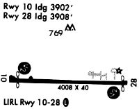
Runways
Runway Summary
| Runways: | 10/28 |
| Longest Runway: | 10/28 is 4008 ft (1222 m) long |
| Runways with an Instrument Approach: |
N94 Airport Runway Details
| Runway 10/28 | 4008 ft x 60 ft (1222 m x 18 m) | |
| Surface: | Asphalt - Good condition - No special surface treatment | |
| Runway Edge Lights: | Low Intensity | |
Runway Weight Bearing Capacity (in thousands of pounds) |
||
| Single Wheel Landing Gear: | 12.5 | |
| Dual Wheel Landing Gear: | 12.5 | |
Runway 10 |
Runway 28 |
|
Elevation: |
502.2 | 509.9 |
Latitude: |
40-11-17.0822N | 40-11-15.8994N |
Longitude: |
077-10-53.1951W | 077-10-01.5756W |
|
Runway True Alignment: |
092 | 272 |
Glide Path Angle: |
0.0 degrees | 0.0 degrees |
Traffic Pattern: |
Left | Left |
Runway Markings Type: |
Basic | Nonprecision Instrument |
Runway Markings Condition: |
Good | Good |
Object at End: |
TREES | |
Object Height: |
100 | |
Distance from End: |
2117 | |
Object Centerline Offset: |
259 ft. left of centerline | |
Threshold Elevation: |
508.3 | |
Displaced Threshold: |
126 | |
Threshold Latitude: |
40-11-15.9364N | |
Threshold Longitude: |
077-10-03.1855W |
Services
Airframe Repair: |
Major |
Powerplant Repair: |
Major |
Bottled Oxygen: |
None |
Bulk Oxygen: |
None |
Fuel Available: |
100LL, Jet A |
Parking: |
Hangars and tiedowns available |
Maps & Diagrams
N94 Sectional
Flight Planning
at skyvector.com
at skyvector.com