Location
Latitude: |
36-18-05.4940N (36.301526) |
Longitude: |
080-08-54.1650W (-80.148379) |
Elevation: |
631.0 feet MSL (192 m MSL) |
Magnetic Variation: |
8.5 W (as of April 2024 from WMM2020 model) |
Time Zone: |
UTC -5.0 (Standard Time) UTC -4.0 (Daylight Savings Time) |
From City: |
01 N.M. NW of Walnut Cove, North Carolina |
Found On: |
Cincinnati Chart |
FAA Region: |
ASO |
Contacts
Manager: |
Privately owned: |
| LOGAN FULP 1060 AIRPORT ROAD WALNUT COVE, NC 27052 336-413-3967 |
BIG CREEK PROPERTIES 3653 NORTH PATTERSON AVE WINSTON-SALEM, NC 27105 336-661-8032 |
Operations
Airport Status: |
Operational |
Facility Use: |
Public |
Type: |
Airport |
Activation Date: |
09/1966 |
Control tower: |
No |
Attendance (Months/Days/Hours): |
Months/Days/Hours IRREGULAR |
Boundary ARTCC: |
ZTL (Atlanta) |
Responsible ARTCC: |
ZTL (Atlanta) |
Lighting Schedule: |
SEE RMK |
Segmented Circle Indicator: |
No |
Traffic Pattern Altitude (MSL): |
1631 feet (497 m) |
NOTAMs Facility: |
RDU |
NOTAM-D Service: |
Yes |
International Airport of Entry: |
No |
Customs Landing Rights: |
No |
Based Aircraft
| Single Engine: | 4 |
| Multi Engine: | 6 |
Annual Operations (as of 04/20/2022)
| Total Operations: | 12050 | |
| GA Local: | 12000 | 99.6% |
| GA Itinerant: | 50 | 0.4% |
Communications
| CTAF: | 123.000 |
| Unicom: | 123.000 |
| Approach: | GREENSBORO 124.35 124.35 |
| Departure: | GREENSBORO 124.35 124.35 |
Fixed Based Operators (FBOs) & Fuel
(Click on a business for detail)
Please help us keep this information up to date. This is a FREE SERVICE just like everything else on Airport Guide! If you see that a business needs to be added, modified, or deleted please fill out our Update Form.
To add, modify, or delete a business click here.
Please help us keep this information up to date. This is a FREE SERVICE just like everything else on Airport Guide! If you see that a business needs to be added, modified, or deleted please fill out our Update Form.
Area Code: 336 |
| Business Name | Frequency | Phone | Fuel Grade |
|---|---|---|---|
| Ed's Flying Service
Update FBO info |
Unicom 123.0 | 591-7881 | 100LL |
Flight Service Stations
| Primary | Alternate | |
| FSS on Field: | N | |
| FSS Name (ID): | Raleigh(RDU) | |
| Frequency: | ||
| Toll Free Phone: | 1-800-WX-BRIEF |
Instrument Procedures / Charts
FAA Terminal Procedures valid from 0901Z 03/21/24 to 0901Z 04/18/24.
There are various types of charts available for an airport. They are listed in the Page Type column. Here is a legend for those types:
APD - Airport Diagram
DP - Departure Procedure Charts
HOT - Hot Spots
IAP - Instrument Approach Procedure Charts
MIN - Minimums
STAR - Standard Terminal Arrival Charts
| Page Type | Page Name | Volume | Action Since Last Cycle |
|---|---|---|---|
| IAP | VOR/DME OR GPS RWY 34 | SE-2 | |
| MIN | TAKEOFF MINIMUMS | SE-2 |
Terminal Procedures are only available for airports in several countries with more being added all the time. If you are looking for a specific country's charts, please send an email to support(at)airportguide.com stating the country name. This will be used to prioritize the implementation.
Navigation Aids (Navaids) near N63
| Dist (NM) | ID | Morse Code | Name | Type | Freq | True Hdg | Mag Hdg |
|---|---|---|---|---|---|---|---|
| 13.9 | IN | . . _ . | Reeno | NDB | 317 | 183 | 192 |
| 17.1 | OQA | _ _ _ _ _ . _ . _ | Rockingham County | FAN MARKER | 63 | 72 | |
| 17.5 | GSO | _ _ . . . . _ _ _ | Greensboro | VORTAC | 116.20 | 151 | 160 |
| 19.2 | SIF | . . . . . . . _ . | Slammer | NDB | 423 | 75 | 84 |
| 19.5 | AZW | . _ _ _ . . . _ _ | Mount Airy | NDB | 223 | 284 | 292 |
| 20.6 | UV | . . _ . . . _ | Bales | NDB | 396 | 32 | 41 |
| 28.0 | ZEF | _ _ . . . . . _ . | Zephyr | NDB | 326 | 271 | 279 |
| 33.5 | HB | . . . . _ . . . | Alamm | NDB | 361 | 125 | 134 |
| 37.9 | RU | . _ . . . _ | Rovdy | NDB | 275 | 205 | 213 |
| 39.2 | LIB | . _ . . . . _ . . . | Liberty | VORTAC | 113.00 | 138 | 147 |
| 42.3 | DAN | _ . . . _ _ . | Danville | VOR | 113.10 | 67 | 76 |
| 42.6 | HLX | . . . . . _ . . _ . . _ | Hillsville | NDB | 269 | 310 | 318 |
| 47.4 | UKF | . . _ _ . _ . . _ . | Wilki | NDB | 209 | 256 | 264 |
| 48.8 | VU | . . . _ . . _ | Aller | NDB | 346 | 176 | 185 |
| 52.5 | HUR | . . . . . . _ . _ . | Person | NDB | 220 | 94 | 103 |
| 54.4 | PSK | . _ _ . . . . _ . _ | Pulaski | VORTAC | 116.80 | 330 | 338 |
| 55.7 | VIT | . . . _ . . _ | Vinton | NDB | 277 | 13 | 22 |
| 55.8 | TEC | _ . _ . _ . | Tech | NDB | 368 | 347 | 356 |
| 57.2 | JUH | . _ _ _ . . _ . . . . | Ashee | NDB | 410 | 278 | 286 |
| 59.0 | BZM | _ . . . _ _ . . _ _ | Barretts Mountain | VOR-DME | 113.75 | 244 | 252 |
Nearby Airports with Fuel
Notices to Airmen (NOTAMS)
Remarks
| A110-1 | HIGH TRRN IN ALL QUADS. |
| A110-10 | NO TSNT TFC BEFORE DALGT OR AFT DARK. |
| A110-11 | ED'S FLYING SERVICE IS NO LONGER THE FBO IT IS NOW FULP'S AVIATION LLC. |
| A110-2 | +65 FT TREES WITHIN 110 FT OF CNTRLN EAST OF RWY. |
| A110-3 | FENCING IN THE CLEAR ZONE RWYS 16 & 34. |
| A110-4 | +8 FT DROP-OFF AER RWY 16. |
| A110-5 | ARPT CLSD TO TSNTS EXCP PPR CALL 336-403-1796. |
| A110-6 | DO NOT LAND ON GRASS ADJ TO RWY. DEEP DITCHES. |
| A110-8 | FOR CD CTC GREENSBORO APCH AT 336-333-5119. |
| A110-9 | NO HEAVY TRNG TFC NO MORE THAN TWO TOUCH AND GOES AT ONE GIVEN TIME. |
| A40-16/34 | NSTD LIRL; LGTS 30 FT EITHER SIDE OF ASPH ALONG OLD TURF RWY. NSTD THR LGTS WITH GREEN, RED, CLEAR AND BI-DIRECTIONAL LENS. |
| A42-16 | RWY MKNG SMALLER THAN NORMAL AND FADED. |
| A42-34 | RWY MKNG SMALLER THAN NORMAL AND FADED; CNTRLN NSTD. |
| A58-16 | SCRUB TREES RANGING FROM 6 FT - 35 FT LCTD 0-200 FT FM THR OFFSET 100 FT RIGHT OF CNTRLN. |
| A58-34 | +3 FT FENCE 30 FT FM THR BOTH SIDES OF CNTRLN. |
| A70-FUEL-10 | 0LL 100LL SELF SVC AVBL BY FULP'S AVIATION. |
| A81-APT | ACTVT LIRL RWY 16/34 - CTAF. |
| E111 | VFR USE ONLY. |
Runways
Runway Summary
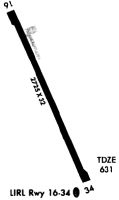
| Runways: | 16/34 |
| Longest Runway: | 16/34 is 2725 ft (831 m) long |
| Runways with an Instrument Approach: |
N63 Airport Runway Details
| Runway 16/34 | 2725 ft x 32 ft (831 m x 10 m) | |
| Surface: | Asphalt - Good condition - No special surface treatment | |
| Runway Edge Lights: | Low Intensity | |
Runway 16 |
Runway 34 |
|
Elevation: |
631.0 | 631.0 |
Latitude: |
36-18-18.1500N | 36-17-52.8300N |
Longitude: |
080-08-59.8600W | 080-08-48.4700W |
|
Runway True Alignment: |
160 | 340 |
Glide Path Angle: |
0.0 degrees | 0.0 degrees |
Traffic Pattern: |
Left | Left |
Runway Markings Type: |
Nonstandard (other than numbers only) | Nonstandard (other than numbers only) |
Runway Markings Condition: |
Fair | Fair |
Object at End: |
TREES | TREES |
Object Height: |
29 | 25 |
Distance from End: |
336 | 377 |
Object Centerline Offset: |
92 ft. right of centerline | 34 ft. left of centerline |
Services
Airframe Repair: |
Major |
Powerplant Repair: |
Major |
Bulk Oxygen: |
None |
Fuel Available: |
100LL, Jet A+ |
Landing Fees: |
No |
Parking: |
Hangars and tiedowns available |
Maps & Diagrams
N63 Sectional
Flight Planning
at skyvector.com
at skyvector.com