Location
Latitude: |
41-22-04.4000N (41.367889) |
Longitude: |
091-08-53.6000W (-91.148222) |
Elevation: |
547.2 feet MSL (167 m MSL) |
Magnetic Variation: |
1.4 W (as of April 2024 from WMM2020 model) |
Time Zone: |
UTC -6.0 (Standard Time) UTC -5.0 (Daylight Savings Time) |
From City: |
05 N.M. SW of Muscatine, Iowa |
Found On: |
Chicago Chart |
FAA Region: |
ACE |
Contacts
Manager: |
Publicly owned: |
| MIKE WOERLY 5701 SOUTH HIGHWAY 61 MUSCATINE, IA 52761 563-263-8672 |
CITY OF MUSCATINE 215 SYCAMORE MUSCATINE, IA 52761 563-264-1550 |
Operations
Airport Status: |
Operational |
Facility Use: |
Public |
Type: |
Airport |
Activation Date: |
05/1947 |
Control tower: |
No |
Attendance (Months/Days/Hours): |
Months/Days/Hours ALL/MON - FRI/0700-1800 |
Boundary ARTCC: |
ZAU (Chicago) |
Responsible ARTCC: |
ZAU (Chicago) |
Lighting Schedule: |
SEE RMK |
Segmented Circle Indicator: |
No |
Traffic Pattern Altitude (MSL): |
1547 feet (472 m) |
NOTAMs Facility: |
MUT |
NOTAM-D Service: |
Yes |
International Airport of Entry: |
No |
Customs Landing Rights: |
No |
Military Landing Rights: |
Yes |
Civil/Military Joint Use: |
No |
Based Aircraft
| Single Engine: | 14 |
| Multi Engine: | 3 |
| Jet Engine: | 1 |
| Gliders: | 6 |
Annual Operations (as of 09/14/2023)
| Total Operations: | 10150 | |
| Air Taxi: | 647 | 6.4% |
| GA Local: | 4751 | 46.8% |
| GA Itinerant: | 4752 | 46.8% |
Communications
| CTAF: | 122.700 |
| Unicom: | 122.700 |
| Clearance Del.: | 119.125 119.125 119.125 |
| Approach: | QUAD CITY CHICAGO ARTCC |
| Departure: | QUAD CITY CHICAGO ARTCC |
| AWOS-3P: | 120.625 (563-263-0902) |
- APCH/DEP SVC PRVDD BY CHICAGO ARTCC ON FREQS 118.75/377.05 (MOLINE RCAG) WHEN QUAD CITY APCH CLSD.
Fixed Based Operators (FBOs) & Fuel
(Click on a business for detail)
Please help us keep this information up to date. This is a FREE SERVICE just like everything else on Airport Guide! If you see that a business needs to be added, modified, or deleted please fill out our Update Form.
To add, modify, or delete a business click here.
Please help us keep this information up to date. This is a FREE SERVICE just like everything else on Airport Guide! If you see that a business needs to be added, modified, or deleted please fill out our Update Form.
Area Code: 563 |
| Business Name | Frequency | Phone | Fuel Grade |
|---|---|---|---|
| Carver Aero
Update FBO info |
Unicom 122.7 | 263-8672 | 100LL, Jet A, MOGAS |
Flight Service Stations
| Primary | Alternate | |
| FSS on Field: | N | |
| FSS Name (ID): | Fort Dodge(FOD) | |
| Frequency: | ||
| Toll Free Phone: | 1-800-WX-BRIEF |
Instrument Procedures / Charts
FAA Terminal Procedures valid from 0901Z 03/21/24 to 0901Z 04/18/24.
There are various types of charts available for an airport. They are listed in the Page Type column. Here is a legend for those types:
APD - Airport Diagram
DP - Departure Procedure Charts
HOT - Hot Spots
IAP - Instrument Approach Procedure Charts
MIN - Minimums
STAR - Standard Terminal Arrival Charts
| Page Type | Page Name | Volume | Action Since Last Cycle |
|---|---|---|---|
| IAP | ILS OR LOC RWY 24 | NC-3 | Changed |
| IAP | RNAV (GPS) RWY 06 | NC-3 | Changed |
| IAP | RNAV (GPS) RWY 12 | NC-3 | Changed |
| IAP | RNAV (GPS) RWY 24 | NC-3 | Changed |
| IAP | RNAV (GPS) RWY 30 | NC-3 | Changed |
| MIN | ALTERNATE MINIMUMS | NC-3 | |
| MIN | TAKEOFF MINIMUMS | NC-3 |
Terminal Procedures are only available for airports in several countries with more being added all the time. If you are looking for a specific country's charts, please send an email to support(at)airportguide.com stating the country name. This will be used to prioritize the implementation.
Navigation Aids (Navaids) near MUT
| Dist (NM) | ID | Morse Code | Name | Type | Freq | True Hdg | Mag Hdg |
|---|---|---|---|---|---|---|---|
| 0.1 | DDD | _ . . _ . . _ . . | Port City | DME | 116.5 | 206 | 207 |
| 22.8 | IOW | . . _ _ _ . _ _ | Iowa City | VOR-DME | 116.20 | 293 | 294 |
| 23.1 | MZV | _ _ _ _ . . . . . _ | Moline | VOR-DME | 114.40 | 96 | 98 |
| 24.2 | AWG | . _ . _ _ _ _ . | Washington | NDB | 219 | 257 | 258 |
| 29.3 | DVN | _ . . . . . _ _ . | Davenport Municipal | VOT | 111.80 | 59 | 61 |
| 30.1 | MPZ | _ _ . _ _ . _ _ . . | Mount Pleasant | NDB | 212 | 213 | 214 |
| 36.2 | CVA | _ . _ . . . . _ . _ | Davenport | VORTAC | 113.80 | 55 | 57 |
| 40.0 | BRL | _ . . . . _ . . _ . . | Burlington | VOR-DME | 111.40 | 165 | 167 |
| 41.1 | FN | . . _ . _ . | Hillz | NDB | 517 | 55 | 57 |
| 41.3 | GBG | _ _ . _ . . . _ _ . | Galesburg | DME | 109.8 | 128 | 130 |
| 42.3 | CID | _ . _ . . . _ . . | Cedar Rapids | VOR-DME | 114.10 | 317 | 318 |
| 42.8 | BR | _ . . . . _ . | Burns | NDB | 390 | 178 | 179 |
| 43.6 | FFL | . . _ . . . _ . . _ . . | Fairfield | NDB | 332 | 240 | 241 |
| 55.7 | EOK | . _ _ _ _ . _ | Keokuk | NDB | 366 | 193 | 194 |
| 56.9 | OTM | _ _ _ _ _ _ | Ottumwa | VOR-DME | 111.60 | 249 | 250 |
| 57.5 | JZY | . _ _ _ _ _ . . _ . _ _ | Macomb | NDB | 251 | 152 | 154 |
| 61.0 | OOA | _ _ _ _ _ _ . _ | Oskaloosa | NDB | 414 | 262 | 263 |
| 62.3 | DB | _ . . _ . . . | Zilom | NDB | 341 | 23 | 25 |
| 64.6 | BOZ | _ . . . _ _ _ _ _ . . | Whiteside | NDB | 254 | 70 | 72 |
| 65.0 | DBQ | _ . . _ . . . _ _ . _ | Dubuque | VORTAC | 115.80 | 17 | 19 |
Nearby Airports with Fuel
Notices to Airmen (NOTAMS)
Remarks
| A110*G | THIS AIRPORT HAS BEEN SURVEYED BY THE NATIONAL GEODETIC SURVEY. |
| A110-1 | GLIDER OPN ON ARPT. |
| A110-2 | FOR CD CTC CHICAGO ARTCC AT 630-906-8921. |
| A17 | FOR ATTENDANT AFT HRS CALL (563) 263-8672; ARPT UNATNDD CITY HOLIDAYS. |
| A81-APT | MIRL RYS 06/24 & 12/30 PRESET ON LOW INTST; TO INCR INTST & ACTVT VASI RY 06; MALSR RY 24; PAPI RYS 24, 12 & 30; REIL RYS 06; 12 & 30 - CTAF. |
| E111 | EXISTED PRIOR TO 1959. |
Runways
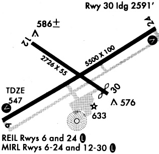
Runway Summary
| Runways: | 06/24 12/30 |
| Longest Runway: | 06/24 is 5500 ft (1676 m) long |
| Runways with an Instrument Approach: | 24 |
MUT Airport Runway Details
| Runway 06/24 | 5500 ft x 100 ft (1676 m x 30 m) | |
| Runway Length Source: | 3RD PARTY SURVEY as of 06/08/2010 | |
| Surface: | Concrete - Good condition - Saw-cut or plastic grooved | |
| Runway Pavement Class: | 20 /R/C/W/T | |
| Runway Edge Lights: | Medium Intensity | |
Runway Weight Bearing Capacity (in thousands of pounds) |
||
| Single Wheel Landing Gear: | 58.0 | |
| Dual Wheel Landing Gear: | 73.0 | |
Runway 06 |
Runway 24 |
|
Elevation: |
544.7 | 541.4 |
Latitude: |
41-21-44.2700N | 41-22-12.6632N |
Longitude: |
091-09-15.9837W | 091-08-14.4817W |
|
Runway True Alignment: |
058 | 239 |
ILS Type: |
ILS/DME | |
Glide Path Angle: |
3.0 degrees | 3.0 degrees |
Traffic Pattern: |
Left | Left |
Runway Markings Type: |
Nonprecision Instrument | Precision Instrument |
Runway Markings Condition: |
Fair | Fair |
Object at End: |
TREE | |
Object Height: |
77 | |
Distance from End: |
2097 | |
Object Centerline Offset: |
102 ft. left of centerline | |
Visual Glide Slope Indicators: |
4-Box VASI On Left Side Of Runway | 4-Light PAPI On Right Side Of Runway |
Approach Light System: |
1,400 Foot Medium Intensity Approach Lighting System With Runway Alignment Indicator Lights | |
REIL: |
Yes | No |
Threshold Crossing Height: |
37 | 52 |
| Runway 12/30 | 4000 ft x 75 ft (1219 m x 23 m) | |
| Runway Length Source: | STATE as of 06/08/2010 | |
| Surface: | Concrete - Good condition - Saw-cut or plastic grooved | |
| Runway Pavement Class: | 9 /R/C/W/T | |
| Runway Edge Lights: | Medium Intensity | |
Runway Weight Bearing Capacity (in thousands of pounds) |
||
| Single Wheel Landing Gear: | 28.5 | |
| Dual Wheel Landing Gear: | 39.0 | |
Runway 12 |
Runway 30 |
|
Elevation: |
535.8 | 543.1 |
Latitude: |
41-22-23.8383N | 41-22-01.1254N |
Longitude: |
091-09-26.6390W | 091-08-43.7023W |
|
Runway True Alignment: |
125 | 305 |
Glide Path Angle: |
3.0 degrees | 3.0 degrees |
Runway Markings Type: |
Nonprecision Instrument | Nonprecision Instrument |
Runway Markings Condition: |
Fair | Fair |
Object at End: |
TREE | |
Object Height: |
8 | |
Distance from End: |
353 | |
Object Centerline Offset: |
102 ft. left of centerline | |
Visual Glide Slope Indicators: |
4-Light PAPI On Left Side Of Runway | 4-Light PAPI On Left Side Of Runway |
REIL: |
Yes | Yes |
Threshold Crossing Height: |
44 | 40 |
Services
Airframe Repair: |
None |
Powerplant Repair: |
None |
Fuel Available: |
100LL, Jet A |
Parking: |
Tiedowns available |
Maps & Diagrams
MUT Sectional
Flight Planning
at skyvector.com
at skyvector.com