Location
Latitude: |
41-34-20.8810N (41.572467) |
Longitude: |
086-44-04.3000W (-86.734528) |
Elevation: |
812.0 feet MSL (247 m MSL) |
Magnetic Variation: |
4.8 W (as of April 2024 from WMM2020 model) |
Time Zone: |
UTC -6.0 (Standard Time) UTC -5.0 (Daylight Savings Time) |
From City: |
03 N.M. S of La Porte, Indiana |
Found On: |
Chicago Chart |
FAA Region: |
AGL |
Contacts
Manager: |
Publicly owned: |
| ERIC BOBCEK 2341 STATE RD 39S LA PORTE, IN 46350 219-324-3393 |
LA PORTE ARPT AUTH 2341 STATE RD 39S LA PORTE, IN 46350 219-324-3393 |
Operations
Airport Status: |
Operational |
Facility Use: |
Public |
Type: |
Airport |
Activation Date: |
04/1940 |
Control tower: |
No |
Attendance (Months/Days/Hours): |
Months/Days/Hours ALL/MON-FRI/0700-1700 |
Boundary ARTCC: |
ZAU (Chicago) |
Responsible ARTCC: |
ZAU (Chicago) |
Lighting Schedule: |
SEE RMK |
Segmented Circle Indicator: |
Yes |
Traffic Pattern Altitude (MSL): |
1812 feet (552 m) |
NOTAMs Facility: |
HUF |
NOTAM-D Service: |
Yes |
International Airport of Entry: |
No |
Customs Landing Rights: |
No |
Military Landing Rights: |
Yes |
Civil/Military Joint Use: |
No |
Based Aircraft
| Single Engine: | 66 |
| Multi Engine: | 4 |
| Jet Engine: | 2 |
Annual Operations (as of 12/31/2019)
| Total Operations: | 15774 | |
| GA Local: | 7414 | 47.0% |
| GA Itinerant: | 8360 | 53.0% |
Communications
| CTAF: | 123.000 |
| Unicom: | 123.000 |
| Approach: | SOUTH BEND 132.05 132.05 CHICAGO ARTCC |
| Departure: | SOUTH BEND 132.05 132.05 CHICAGO ARTCC |
| AWOS-3PT: | 119.825 (219-326-6916) |
- APCH/DEP SVC PRVDD BY CHICAGO ARTCC ON FREQS 135.9/314.0 (GOSHEN RCAG) WHEN SOUTH BEND APCH CTL CLSD.
Fixed Based Operators (FBOs) & Fuel
(Click on a business for detail)
Please help us keep this information up to date. This is a FREE SERVICE just like everything else on Airport Guide! If you see that a business needs to be added, modified, or deleted please fill out our Update Form.
To add, modify, or delete a business click here.
Please help us keep this information up to date. This is a FREE SERVICE just like everything else on Airport Guide! If you see that a business needs to be added, modified, or deleted please fill out our Update Form.
Area Code: 219 |
| Business Name | Frequency | Phone | Fuel Grade |
|---|
Flight Service Stations
| Primary | Alternate | |
| FSS on Field: | N | |
| FSS Name (ID): | Terre Haute(HUF) | |
| Frequency: | ||
| Toll Free Phone: | 1-800-WX-BRIEF |
Instrument Procedures / Charts
FAA Terminal Procedures valid from 0901Z 03/21/24 to 0901Z 04/18/24.
There are various types of charts available for an airport. They are listed in the Page Type column. Here is a legend for those types:
APD - Airport Diagram
DP - Departure Procedure Charts
HOT - Hot Spots
IAP - Instrument Approach Procedure Charts
MIN - Minimums
STAR - Standard Terminal Arrival Charts
| Page Type | Page Name | Volume | Action Since Last Cycle |
|---|---|---|---|
| IAP | RNAV (GPS) RWY 02 | EC-2 | Changed |
| IAP | RNAV (GPS) RWY 20 | EC-2 | Changed |
| MIN | ALTERNATE MINIMUMS | EC-2 | |
| MIN | TAKEOFF MINIMUMS | EC-2 |
Terminal Procedures are only available for airports in several countries with more being added all the time. If you are looking for a specific country's charts, please send an email to support(at)airportguide.com stating the country name. This will be used to prioritize the implementation.
Navigation Aids (Navaids) near LPO
| Dist (NM) | ID | Morse Code | Name | Type | Freq | True Hdg | Mag Hdg |
|---|---|---|---|---|---|---|---|
| 4.7 | IUL | . . . . _ . _ . . | La Porte | NDB | 356 | 200 | 205 |
| 9.7 | VP | . . . _ . _ _ . | Sedly | NDB | 212 | 221 | 226 |
| 15.5 | OXI | _ _ _ _ . . _ . . | Knox | DME | 115.6 | 165 | 170 |
| 22.0 | GIJ | _ _ . . . . _ _ _ | Gipper | VORTAC | 115.40 | 57 | 62 |
| 24.5 | SB | . . . _ . . . | Misha | NDB | 341 | 70 | 75 |
| 26.5 | CPB | _ . _ . . _ _ . _ . . . | Culver | NDB | 391 | 143 | 148 |
| 29.3 | RWN | . _ . . _ _ _ . | Winamac/Dcmsnd | NDB | 335 | 168 | 173 |
| 31.9 | GSH | _ _ . . . . . . . . | Goshen | VORTAC | 113.70 | 94 | 99 |
| 37.8 | CGT | _ . _ . _ _ . _ | Chicago Heights | VORTAC | 114.20 | 264 | 268 |
| 38.2 | BE | _ . . . . | Mally | NDB | 397 | 29 | 34 |
| 43.9 | ELX | . . _ . . _ . . _ | Keeler | VOR-DME | 116.60 | 38 | 43 |
| 44.0 | MX | _ _ _ . . _ | Kedzi | NDB | 248 | 283 | 287 |
| 47.4 | MDW | _ _ _ . . . _ _ | Chicago Midway | VOT | 111.00 | 286 | 290 |
| 50.2 | HK | . . . . _ . _ | Ermin | NDB | 332 | 280 | 284 |
| 50.9 | EON | . _ _ _ _ . | Peotone | VORTAC | 113.20 | 249 | 253 |
| 56.1 | HAI | . . . . . _ . . | Three Rivers | NDB | 407 | 65 | 70 |
| 58.0 | ORD | _ _ _ . _ . _ . . | Chicago O'hare | VOR-DME | 113.90 | 295 | 299 |
| 58.0 | GCO | _ _ . _ . _ . _ _ _ | Chicago | DME | 108.25 | 296 | 300 |
| 58.5 | IKK | . . _ . _ _ . _ | Kankakee | DME | 111.6 | 239 | 243 |
| 59.0 | OLK | _ _ _ . _ . . _ . _ | Webster Lake | VOR | 110.40 | 108 | 113 |
Nearby Airports with Fuel
Notices to Airmen (NOTAMS)
Remarks
| A11 | EDWARD VOLK |
| A110-2 | FARM EQUIP ON OR NEAR OPS AREAS. |
| A110-3 | TWY LGTS AT TWY ENTRANCE ONLY. |
| A110-4 | FOR CD CTC SOUTH BEND APCH AT 574-251-2609. WHEN SOUTH BEND APCH CLSD, FOR CD CTC CHICAGO ARTCC AT 630-906-8921. |
| A110-5 | SVC AFT HR - 219-608-4707 OR 219-363-6659. |
| A43-32 | UNUSBL BYD 2 DEGS LEFT OF CNTRLN. |
| A56-14 | CLOSEST INTCP POINT. |
| A56-32 | CLOSEST INTCP POINT. |
| A57-14 | APCH SLOPE 35:1 FM DTHR. |
| A58-14 | 10 FT CROPS 80 FT FM RWY END 75 FT R & 150 FT L. |
| A58-20 | 10 FT CROPS 160 FT L OF RWY END. |
| A70-FUEL-10 | 0LL TRML FUEL AVBL DURG ATND HR OR SVC CALL. SELF SERVE FUEL H24 E SIDE. |
| A81-APT | ACTVT REIL RWY 02, 14, 20, & 32; PAPI RWY 02, 20, & 32; MIRL RWY 02/20 & 14/32 - CTAF. |
| E111 | EXISTED PRIOR TO 1959. |
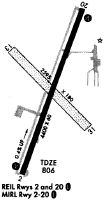
Runways
Runway Summary
| Runways: | 02/20 14/32 |
| Longest Runway: | 02/20 is 5000 ft (1524 m) long |
| Runways with an Instrument Approach: | 02 |
LPO Airport Runway Details
| Runway 02/20 | 5000 ft x 75 ft (1524 m x 23 m) | |
| Runway Length Source: | 3RD PARTY SURVEY as of 11/23/2020 | |
| Surface: | Asphalt - Good condition - Saw-cut or plastic grooved | |
| Runway Edge Lights: | Medium Intensity | |
Runway Weight Bearing Capacity (in thousands of pounds) |
||
| Single Wheel Landing Gear: | 18.0 | |
Runway 02 |
Runway 20 |
|
Elevation: |
800.3 | 811.9 |
Latitude: |
41-33-55.9609N | 41-34-42.3496N |
Longitude: |
086-44-15.5316W | 086-43-52.9185W |
|
Runway True Alignment: |
020 | 200 |
ILS Type: |
LOCALIZER | |
Glide Path Angle: |
3.0 degrees | 3.5 degrees |
Traffic Pattern: |
Left | Left |
Runway Markings Type: |
Nonprecision Instrument | Nonprecision Instrument |
Runway Markings Condition: |
Good | Good |
Object at End: |
CROPS | CROPS |
Object Height: |
10 | 10 |
Distance from End: |
201 | 201 |
Object Centerline Offset: |
240 ft. right of centerline | 160 ft. left of centerline |
Visual Glide Slope Indicators: |
2-Light PAPI On Left Side Of Runway | 2-Light PAPI On Left Side Of Runway |
REIL: |
Yes | Yes |
Touchdown Lights: |
No | No |
Centerline Lights: |
No | No |
Threshold Crossing Height: |
24 | 27 |
| Runway 14/32 | 2797 ft x 60 ft (853 m x 18 m) | |
| Runway Length Source: | 3RD PARTY SURVEY as of 11/23/2020 | |
| Surface: | Asphalt - Good condition - No special surface treatment | |
| Runway Edge Lights: | Medium Intensity | |
Runway 14 |
Runway 32 |
|
Elevation: |
810.0 | 799.3 |
Latitude: |
41-34-33.7269N | 41-34-14.2060N |
Longitude: |
086-44-17.4589W | 086-43-51.4089W |
|
Runway True Alignment: |
135 | 315 |
Glide Path Angle: |
0.0 degrees | 3.5 degrees |
Traffic Pattern: |
Left | Left |
Runway Markings Type: |
Basic | Basic |
Runway Markings Condition: |
Good | Good |
Object at End: |
CROPS | CROPS |
Object Height: |
10 | 10 |
Distance from End: |
201 | 201 |
Object Centerline Offset: |
240 ft. right of centerline | 160 ft. left of centerline |
Visual Glide Slope Indicators: |
2-Light PAPI On Left Side Of Runway | |
REIL: |
Yes | Yes |
Touchdown Lights: |
No | No |
Centerline Lights: |
No | No |
Threshold Crossing Height: |
33 | |
Threshold Elevation: |
810.1 | 800.0 |
Displaced Threshold: |
199 | 198 |
Threshold Latitude: |
41-34-32.3355N | 41-34-15.5862N |
Threshold Longitude: |
086-44-15.6018W | 086-43-53.2483W |
Services
Airframe Repair: |
Major |
Powerplant Repair: |
Major |
Bottled Oxygen: |
High Pressure |
Fuel Available: |
100LL, Jet A |
Landing Fees: |
No |
Parking: |
Hangars and tiedowns available |
Maps & Diagrams
LPO Sectional
Flight Planning
at skyvector.com
at skyvector.com