
Location
Latitude: |
27-55-54.8401N (27.9319) |
Longitude: |
015-23-11.7583W (-15.3866) |
Elevation: |
78 feet MSL (24 m MSL) |
Magnetic Variation: |
3.6 W (as of April 2024 from WMM2020 model) |
Time Zone: |
UTC +0.0 (Standard Time) UTC +1.0 (Daylight Savings Time) |
Contacts
Manager: |
: |
Operations
Airport Status: |
Operational |
Facility Use: |
Public |
Type: |
Airport |
Traffic Pattern Altitude (MSL): |
1078 feet (329 m) |
Based Aircraft
Annual Operations (as of )
Communications
| TWR: | 118.3 |
| WAECHTERSBERG INFO: | 119.415 |
| GND: | 121.7 |
| APP: | 120.9 |
| ATIS: | 118.6 |
Fixed Based Operators (FBOs) & Fuel
(Click on a business for detail)
Please help us keep this information up to date. This is a FREE SERVICE just like everything else on Airport Guide! If you see that a business needs to be added, modified, or deleted please fill out our Update Form.
To add, modify, or delete a business click here.
Please help us keep this information up to date. This is a FREE SERVICE just like everything else on Airport Guide! If you see that a business needs to be added, modified, or deleted please fill out our Update Form.
| Business Name | Frequency | Phone | Fuel Grade |
|---|
Flight Service Stations
| Primary | Alternate | |
| FSS on Field: | ||
| FSS Name (ID): | ||
| Frequency: | ||
| Toll Free Phone: |
Instrument Procedures / Charts
Terminal Procedures are only available for airports in several countries with more being added all the time. If you are looking for a specific country's charts, please send an email to support(at)airportguide.com stating the country name. This will be used to prioritize the implementation.
Navigation Aids (Navaids) near LPA
| Dist (NM) | ID | Morse Code | Name | Type | Freq | True Hdg | Mag Hdg |
|---|---|---|---|---|---|---|---|
| 0.5 | TGN | Gran Canaria | TACAN | 115.60 | 196 | 200 | |
| 4.8 | VR | Gran Canaria | NDB | 365 | 201 | 205 | |
| 6.7 | LPC | Gran Canaria | VOR-DME | 115.00 | 201 | 205 | |
| 9.0 | GDV | Gran Canaria | VOR-DME | 112.90 | 345 | 349 | |
| 55.7 | TX | Tenerife Norte | NDB | 410 | 304 | 308 | |
| 59.1 | TFN | Tenerife Norte | VOR-DME | 117.70 | 308 | 312 | |
| 62.7 | TES | Tenerife Sur | NDB | 317 | 277 | 281 | |
| 69.1 | TFS | Tenerife Sur | VOR-DME | 116.40 | 273 | 277 | |
| 85.9 | FTV | Fuerteventura | VOR-DME | 114.10 | 69 | 72 | |
| 97.0 | LGM | La Gomera | VOR-DME | 116.00 | 273 | 277 |
Nearby Airports with Fuel
| Dist (NM) | Name (Airport IDs) | True Hdg | Mag Hdg | Fuel Grade |
|---|
Notices to Airmen (NOTAMS)
Remarks
No remarks for this landing facility
Runways
Runway Summary
| Runways: | 03L/21R 03R/21L |
| Longest Runway: | 03L/21R is 10171 ft (3100 m) long |
| Runways with an Instrument Approach: |
LPA Airport Runway Details
| Runway 03L/21R | 10171 ft x 148 ft (3100 m x 45 m) | |
| Runway Edge Lights: | Yes Intensity | |
Runway 03L |
Runway 21R |
|
Elevation: |
78 | 33 |
Latitude: |
27.91889953613 | 27.94490051269 |
Longitude: |
-15.39229965209 | -15.38080024719 |
|
Runway True Alignment: |
22 | 202 |
Glide Path Angle: |
0.0 degrees | 0.0 degrees |
REIL: |
Yes | Yes |
Threshold Elevation: |
78 | 33 |
| Runway 03R/21L | 10171 ft x 148 ft (3100 m x 45 m) | |
| Runway Edge Lights: | Yes Intensity | |
Runway 03R |
Runway 21L |
|
Elevation: |
69 | 27 |
Latitude: |
27.91819953918 | 27.94420051574 |
Longitude: |
-15.39039993286 | -15.37880039215 |
|
Runway True Alignment: |
22 | 202 |
Glide Path Angle: |
0.0 degrees | 0.0 degrees |
REIL: |
Yes | Yes |
Threshold Elevation: |
69 | 27 |
Services
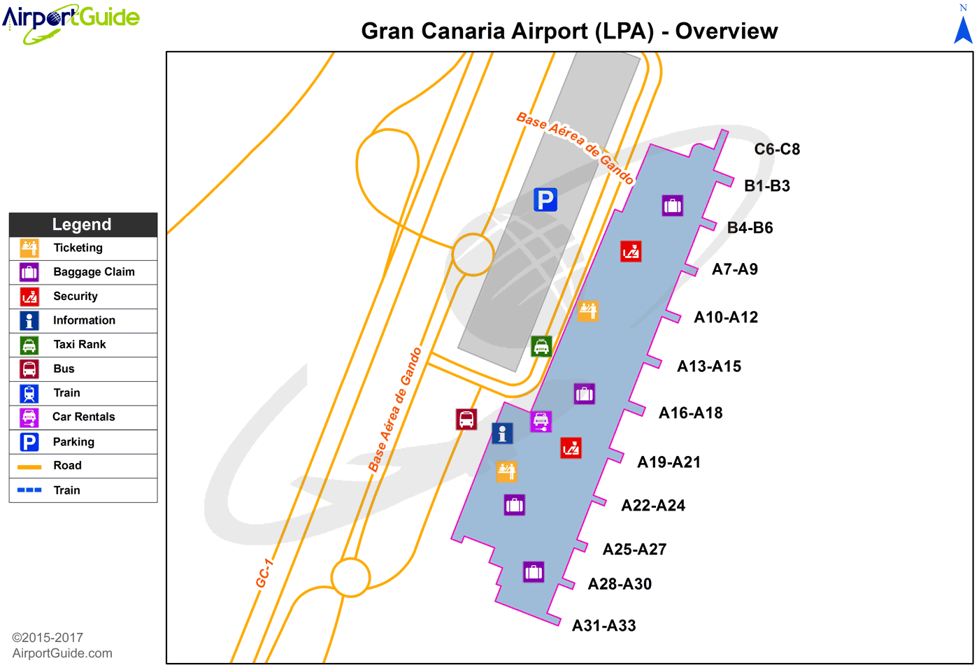
Maps & Diagrams
LPA Sectional
Flight Planning
at skyvector.com
at skyvector.com
