Location
Latitude: |
42-09-40.0000N (42.161111) |
Longitude: |
120-23-56.7000W (-120.399083) |
Elevation: |
4734.1 feet MSL (1443 m MSL) |
Magnetic Variation: |
13.6 E (as of April 2024 from WMM2020 model) |
Time Zone: |
UTC -8.0 (Standard Time) UTC -7.0 (Daylight Savings Time) |
From City: |
03 N.M. SW of Lakeview, Oregon |
Found On: |
Klamath Falls Chart |
FAA Region: |
ANM |
Contacts
Manager: |
Publicly owned: |
| TRISTAN WITHAM 17819 AIRPORT ROAD LAKE VIEW, OR 97630 541-947-4222 |
LAKE COUNTY LAKE COUNTY COURTHOUSE, 513 CENTER STREET LAKEVIEW, OR 97630 541-947-6003 |
Operations
Airport Status: |
Operational |
Facility Use: |
Public |
Type: |
Airport |
Activation Date: |
12/1943 |
Control tower: |
No |
Attendance (Months/Days/Hours): |
Months/Days/Hours APR-SEP/ALL/0900-1600 |
Boundary ARTCC: |
ZSE (Seattle) |
Responsible ARTCC: |
ZSE (Seattle) |
Lighting Schedule: |
SEE RMK |
Segmented Circle Indicator: |
Yes |
Traffic Pattern Altitude (MSL): |
5734 feet (1748 m) |
NOTAMs Facility: |
LKV |
NOTAM-D Service: |
Yes |
International Airport of Entry: |
No |
Customs Landing Rights: |
No |
Military Landing Rights: |
Yes |
Civil/Military Joint Use: |
No |
Based Aircraft
| Single Engine: | 15 |
| Multi Engine: | 2 |
Annual Operations (as of 06/09/2019)
| Total Operations: | 6000 | |
| Air Taxi: | 1200 | 20.0% |
| GA Local: | 1500 | 25.0% |
| GA Itinerant: | 3300 | 55.0% |
Communications
| CTAF: | 122.800 |
| Unicom: | 122.800 |
| AWOS-3PT: | 135.525 (541-947-5069) |
- APCH/DEP CTL SVC PRVDD BY SEATTLE ARTCC (ZSE) ON FREQS 127.6/346.35 (KLAMATH FALLS RCAG).
Fixed Based Operators (FBOs) & Fuel
(Click on a business for detail)
Please help us keep this information up to date. This is a FREE SERVICE just like everything else on Airport Guide! If you see that a business needs to be added, modified, or deleted please fill out our Update Form.
To add, modify, or delete a business click here.
Please help us keep this information up to date. This is a FREE SERVICE just like everything else on Airport Guide! If you see that a business needs to be added, modified, or deleted please fill out our Update Form.
Area Code: 541 |
| Business Name | Frequency | Phone | Fuel Grade |
|---|---|---|---|
| Goose Lake Aviation
Update FBO info |
Unicom 122.8 | 947-4222, -3592 | 100LL |
Flight Service Stations
| Primary | Alternate | |
| FSS on Field: | N | |
| FSS Name (ID): | Mc Minnville(MMV) | |
| Frequency: | ||
| Toll Free Phone: | 1-800-WX-BRIEF |
Instrument Procedures / Charts
FAA Terminal Procedures valid from 0901Z 03/21/24 to 0901Z 04/18/24.
There are various types of charts available for an airport. They are listed in the Page Type column. Here is a legend for those types:
APD - Airport Diagram
DP - Departure Procedure Charts
HOT - Hot Spots
IAP - Instrument Approach Procedure Charts
MIN - Minimums
STAR - Standard Terminal Arrival Charts
| Page Type | Page Name | Volume | Action Since Last Cycle |
|---|---|---|---|
| IAP | RNAV (GPS) RWY 17 | NW-1 | |
| IAP | RNAV (GPS) RWY 35 | NW-1 | |
| MIN | ALTERNATE MINIMUMS | NW-1 | |
| MIN | TAKEOFF MINIMUMS | NW-1 |
Terminal Procedures are only available for airports in several countries with more being added all the time. If you are looking for a specific country's charts, please send an email to support(at)airportguide.com stating the country name. This will be used to prioritize the implementation.
Navigation Aids (Navaids) near LKV
| Dist (NM) | ID | Morse Code | Name | Type | Freq | True Hdg | Mag Hdg |
|---|---|---|---|---|---|---|---|
| 20.5 | LKV | . _ . . _ . _ . . . _ | Lakeview | VORTAC | 112.00 | 346 | 332 |
| 59.1 | LMT | . _ . . _ _ _ | Klamath Falls | VORTAC | 115.90 | 269 | 255 |
| 96.5 | MOG | _ _ _ _ _ _ _ . | Montague | NDB | 404 | 255 | 241 |
Nearby Airports with Fuel
| Dist (NM) | Name (Airport IDs) | True Hdg | Mag Hdg | Fuel Grade |
|---|---|---|---|---|
| 37.9 | Cedarville Airport (O59) |
163 | 150 | 100LL |
| 41.4 | Alturas Municipal Airport (KAAT AAT) |
190 | 177 | 100LL, Jet A |
| 45.8 | Tulelake Municipal Airport (O81) |
249 | 235 | 100LL |
| 59.3 | Crater Lake/Klamath Regional Airport (LMT KLMT LMT) |
270 | 256 | 100LL, Jet A |
| 82.9 | Fall River Mills Airport (O89) |
214 | 200 | 100LL |
| 95.1 | Siskiyou County Airport (SIY KSIY SIY) |
256 | 242 | Jet A |
| 99.2 | Montague-Yreka Rohrer Field Airport (ROF 1O5) |
255 | 241 | 100LL |
Notices to Airmen (NOTAMS)
Remarks
| A110-1 | FLOCKS OF LARGE WATERFOWL IN VICINITY NOV-MAY. |
| A110-2 | EXTENSIVE AIRTANKER OPNS IN FIRE SEASON. |
| A110-3 | DRAG STRIP ORIENTED NW-SE LOCATED 3000 FT SW OF RY 35. |
| A110-4 | POSSIBLE GLIDER OPERATIONS ON TWY. |
| A110-5 | TWY NE/SW USED FOR STRONG CROSS WIND LNDG. |
| A110-6 | WILDLIFE ON AND INVOF ARPT. |
| A110-7 | FOR CD IF UNA TO CTC ON FSS FREQ, CTC SEATTLE ARTCC AT 253-351-3694. |
| A81-APT | ACTVT MIRL RWY 17/35, PAPI 17 & 35; REIL RWY 17 & 35 - CTAF. |
| A83 | TETRAHEDRON LIGHTING INOPERATIVE. |
| E111 | ESTABLISHED PRIOR TO 1959. |
Runways
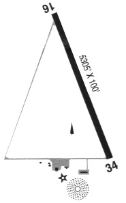
Runway Summary
| Runways: | 17/35 |
| Longest Runway: | 17/35 is 5318 ft (1621 m) long |
| Runways with an Instrument Approach: |
LKV Airport Runway Details
| Runway 17/35 | 5318 ft x 100 ft (1621 m x 30 m) | |
| Runway Length Source: | 3RD PARTY SURVEY as of 09/06/2017 | |
| Surface: | Asphalt - Good condition - No special surface treatment | |
| Runway Edge Lights: | Medium Intensity | |
Runway Weight Bearing Capacity (in thousands of pounds) |
||
| Single Wheel Landing Gear: | 74.0 | |
| Dual Wheel Landing Gear: | 86.0 | |
Runway 17 |
Runway 35 |
|
Elevation: |
4734.1 | 4725.1 |
Latitude: |
42-10-06.2388N | 42-09-13.7172N |
Longitude: |
120-23-56.5233W | 120-23-56.8344W |
|
Runway True Alignment: |
180 | 000 |
Glide Path Angle: |
3.0 degrees | 3.0 degrees |
Traffic Pattern: |
Left | Left |
Runway Markings Type: |
Nonprecision Instrument | Nonprecision Instrument |
Runway Markings Condition: |
Good | Good |
Visual Glide Slope Indicators: |
4-Light PAPI On Right Side Of Runway | 4-Light PAPI On Left Side Of Runway |
REIL: |
Yes | Yes |
Threshold Crossing Height: |
45 | 45 |
Services
Airframe Repair: |
Minor |
Powerplant Repair: |
Minor |
Fuel Available: |
100LL |
Landing Fees: |
No |
Parking: |
Tiedowns available |
Maps & Diagrams
LKV Sectional
Flight Planning
at skyvector.com
at skyvector.com