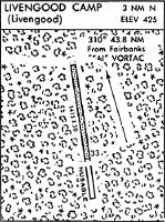
Location
Latitude: |
65-28-02.1700N (65.467269) |
Longitude: |
148-39-13.4900W (-148.653747) |
Elevation: |
427.5 feet MSL (130 m MSL) |
Magnetic Variation: |
15.4 E (as of April 2024 from WMM2020 model) |
Time Zone: |
UTC -9.0 (Standard Time) UTC -8.0 (Daylight Savings Time) |
From City: |
00 N.M. E of Livengood, Alaska |
Found On: |
Fairbanks Chart |
FAA Region: |
AAL |
Contacts
Manager: |
Publicly owned: |
| JEFF RUSSELL 2301 PEGER RD FAIRBANKS, AK 99709 907-451-2207 |
ALASKA DOT&PF NORTHERN REGION 2301 PEGER RD FAIRBANKS, AK 99709 907-451-2200 |
Operations
Airport Status: |
Operational |
Facility Use: |
Public |
Type: |
Airport |
Activation Date: |
07/1975 |
Control tower: |
No |
Attendance (Months/Days/Hours): |
Months/Days/Hours Unattended |
Boundary ARTCC: |
ZAN (Anchorage) |
Responsible ARTCC: |
ZAN (Anchorage) |
Segmented Circle Indicator: |
No |
Traffic Pattern Altitude (MSL): |
1428 feet (435 m) |
NOTAMs Facility: |
FAI |
NOTAM-D Service: |
Yes |
International Airport of Entry: |
No |
Customs Landing Rights: |
No |
Military Landing Rights: |
Yes |
Based Aircraft
Annual Operations (as of 12/31/2019)
| Total Operations: | 100 | |
| Air Taxi: | 100 | 100.0% |
Communications
| CTAF: | 122.900 |
Fixed Based Operators (FBOs) & Fuel
(Click on a business for detail)
Please help us keep this information up to date. This is a FREE SERVICE just like everything else on Airport Guide! If you see that a business needs to be added, modified, or deleted please fill out our Update Form.
To add, modify, or delete a business click here.
Please help us keep this information up to date. This is a FREE SERVICE just like everything else on Airport Guide! If you see that a business needs to be added, modified, or deleted please fill out our Update Form.
Area Code: 907 |
| Business Name | Frequency | Phone | Fuel Grade |
|---|
Flight Service Stations
| Primary | Alternate | |
| FSS on Field: | ||
| FSS Name (ID): | Fairbanks(FAI) | |
| Frequency: | ||
| Toll Free Phone: | 1-866-248-6516 |
Instrument Procedures / Charts
Terminal Procedures are only available for airports in several countries with more being added all the time. If you are looking for a specific country's charts, please send an email to support(at)airportguide.com stating the country name. This will be used to prioritize the implementation.
Navigation Aids (Navaids) near LIV
| Dist (NM) | ID | Morse Code | Name | Type | Freq | True Hdg | Mag Hdg |
|---|---|---|---|---|---|---|---|
| 40.3 | FOX | . . _ . _ _ _ _ . . _ | Fox | NDB | 356 | 137 | 121 |
| 43.2 | FAI | . . _ . . _ . . | Fairbanks | VORTAC | 108.60 | 157 | 142 |
| 47.7 | CUN | _ . _ . . . _ _ . | Chena | NDB | 257 | 141 | 125 |
| 53.7 | ENN | . _ . _ . | Nenana | VORTAC | 115.80 | 191 | 176 |
| 56.3 | ICW | . . _ . _ . . _ _ | Ice Pool | NDB | 525 | 191 | 176 |
| 62.8 | EIL | . . . . _ . . | Eielson | TACAN | 115.10 | 140 | 124 |
| 90.0 | TAL | _ . _ . _ . . | Tanana | VOR-DME | 116.60 | 260 | 245 |
| 90.7 | BCC | _ . . . _ . _ . _ . _ . | Bear Creek | NDB | 212 | 260 | 245 |
| 94.2 | PPC | . _ _ . . _ _ . _ . _ . | Prospect | NDB | 340 | 330 | 315 |
Nearby Airports with Fuel
| Dist (NM) | Name (Airport IDs) | True Hdg | Mag Hdg | Fuel Grade |
|---|---|---|---|---|
| 44.0 | Fairbanks International Airport (FAI PAFA FAI) |
152 | 136 | 100LL, Jet A-1 |
| 53.2 | Bradley Sky-Ranch Airport (95Z) |
142 | 126 | 100LL |
| 56.2 | Nenana Municipal Airport (ENN PANN ENN) |
191 | 176 | 100LL, Jet A |
Notices to Airmen (NOTAMS)
Remarks
| A110-1 | RY NOT MAINTAINED & CONDITION NOT MONITORED, RECOMMEND VISUAL INSPECTION PRIOR TO LANDING. |
| A110-2 | WX CAMERA AVBL ON INTERNET AT HTTPS://WEATHERCAMS.FAA.GOV |
| A110-3 | BE ALERT: -WATCH FOR FREQUENT HELICOPTER TRAFFIC FROM ADJACENT WORK CAMP. |
| A42-15 | RYS 15 & 33 NSTD MKGS; RY EDGES MKD WITH CONES. |
Runways
Runway Summary
| Runways: | 15/33 |
| Longest Runway: | 15/33 is 3000 ft (914 m) long |
| Runways with an Instrument Approach: |
LIV Airport Runway Details
| Runway 15/33 | 3000 ft x 50 ft (914 m x 15 m) | |
| Runway Length Source: | FAA as of 05/12/2015 | |
| Surface: | Gravel - Good condition - No special surface treatment | |
Runway 15 |
Runway 33 |
|
Elevation: |
431.9 | 422.9 |
Latitude: |
65-28-16.8077N | 65-27-47.5232N |
Longitude: |
148-39-17.9966W | 148-39-08.9829W |
Glide Path Angle: |
0.0 degrees | 0.0 degrees |
Traffic Pattern: |
Left | Left |
Runway Markings Type: |
Nonstandard (other than numbers only) | Nonstandard (other than numbers only) |
Object at End: |
TREES | TREES |
Object Height: |
7 | 18 |
Distance from End: |
10 | 12 |
Object Centerline Offset: |
124 ft. left of centerline | 122 ft. left and right of centerline |
Services
Airframe Repair: |
None |
Powerplant Repair: |
None |
Bottled Oxygen: |
None |
Bulk Oxygen: |
None |
Fuel Available: |
100LL, Jet A |
Landing Fees: |
No |
Parking: |
Tiedowns available |
Maps & Diagrams
LIV Sectional
Flight Planning
at skyvector.com
at skyvector.com