Location
Latitude: |
45-14-49.6550N (45.247126) |
Longitude: |
122-46-12.1690W (-122.770047) |
Elevation: |
199.6 feet MSL (61 m MSL) |
Magnetic Variation: |
14.8 E (as of April 2024 from WMM2020 model) |
Time Zone: |
UTC -8.0 (Standard Time) UTC -7.0 (Daylight Savings Time) |
From City: |
01 N.M. NW of Aurora, Oregon |
Found On: |
Seattle Chart |
FAA Region: |
ANM |
Contacts
Manager: |
Publicly owned: |
| ANTHONY BEACH 3040 25TH ST SE SALEM, OR 97302-1125 503-378-4880 |
OREGON DEPT OF AVIATION 3040 25TH ST SE SALEM, OR 97302-1125 503-378-4880 |
Operations
Airport Status: |
Operational |
Facility Use: |
Public |
Type: |
Airport |
Activation Date: |
12/1943 |
Control tower: |
Yes |
Attendance (Months/Days/Hours): |
Months/Days/Hours ALL/ALL/0700-2000 |
Boundary ARTCC: |
ZSE (Seattle) |
Responsible ARTCC: |
ZSE (Seattle) |
Lighting Schedule: |
SEE RMK |
Segmented Circle Indicator: |
Yes |
Traffic Pattern Altitude (MSL): |
1200 feet (366 m) |
NOTAMs Facility: |
UAO |
NOTAM-D Service: |
Yes |
International Airport of Entry: |
No |
Customs Landing Rights: |
No |
Military Landing Rights: |
Yes |
Civil/Military Joint Use: |
No |
Based Aircraft
| Single Engine: | 216 |
| Multi Engine: | 14 |
| Jet Engine: | 40 |
| GA Helicopters: | 8 |
| Gliders: | 3 |
| Ultralights: | 1 |
Annual Operations (as of 09/27/2021)
| Total Operations: | 94935 | |
| Air Taxi: | 7909 | 8.3% |
| GA Local: | 32177 | 33.9% |
| GA Itinerant: | 54569 | 57.5% |
| Military Aircraft: | 280 | 0.3% |
Communications
| CTAF: | 120.350 |
| Tower: | AURORA TWR 120.35 Hrs: 0700-2000 |
| Clearance Del.: | 119.15 |
| Ground: | 119.15 |
| Approach: | PORTLAND 118.1 ;HIGH 118.1 ;HIGH 118.1 ;HIGH 118.1 ;HIGH 118.1 ;HIGH 118.1 ;HIGH 118.1 ;HIGH |
| Departure: | PORTLAND 118.1 ;HIGH 118.1 ;HIGH 118.1 ;HIGH 118.1 ;HIGH 118.1 ;HIGH 118.1 ;HIGH 118.1 ;HIGH |
| ATIS: | 118.525 Hrs: 1500-0400 |
| ASOS: | 118.525 (503-678-3011) |
Fixed Based Operators (FBOs) & Fuel
(Click on a business for detail)
Please help us keep this information up to date. This is a FREE SERVICE just like everything else on Airport Guide! If you see that a business needs to be added, modified, or deleted please fill out our Update Form.
To add, modify, or delete a business click here.
Please help us keep this information up to date. This is a FREE SERVICE just like everything else on Airport Guide! If you see that a business needs to be added, modified, or deleted please fill out our Update Form.
Area Code: 503 |
| Business Name | Frequency | Phone | Fuel Grade |
|---|---|---|---|
| AAA Aviation Maintenance
Update FBO info |
678-2199 | 80, 100LL | |
| Aurora Aviation
Update FBO info |
Unicom 122.7, Arinc 123.3 | 678-1217, 678-5172 | 100LL, Jet A |
| Aurora Jet Center
Website Update FBO info |
122.85 | 503-678-1336 | 100LL, Jet A |

|
AvFuel | 100LL - 6.23 USD per gallon on 9/17/13 |
Trucks Full service |
|
|
AvFuel | 100LL - 6.03 USD per gallon on 9/17/13 |
24 Hour Self Serve Credit Card Pumps |
|
|
AvFuel | Jet A - 4.76 USD per gallon on 9/17/13 |
Trucks |
|
|
AvFuel | Jet A - 4.80 USD per gallon on 9/17/13 |
Trucks with Prist |
| Columbia Helicopters
Update FBO info |
678-1222 | ||
| Pacific Coast Avionics
Website Update FBO info |
678-6242, 800-353-0370 | ||
| Sky West Aviation
Update FBO info |
678-2252 | 100LL | |
| Stenbock & Everson Inc.
Website Update FBO info |
122.7 | 503-678-4360 | |
| Van's Aircraft, Inc.
Website Update FBO info |
503-678-6545 |
Flight Service Stations
| Primary | Alternate | |
| FSS on Field: | N | |
| FSS Name (ID): | Mc Minnville(MMV) | |
| Frequency: | ||
| Toll Free Phone: | 1-800-WX-BRIEF |
Instrument Procedures / Charts
FAA Terminal Procedures valid from 0901Z 03/21/24 to 0901Z 04/18/24.
There are various types of charts available for an airport. They are listed in the Page Type column. Here is a legend for those types:
APD - Airport Diagram
DP - Departure Procedure Charts
HOT - Hot Spots
IAP - Instrument Approach Procedure Charts
MIN - Minimums
STAR - Standard Terminal Arrival Charts
| Page Type | Page Name | Volume | Action Since Last Cycle |
|---|---|---|---|
| APD | AIRPORT DIAGRAM | NW-1 | |
| DP | GLARA TWO (RNAV) | NW-1 | |
| DP | GNNET TWO (RNAV) | NW-1 | |
| DP | NEWBERG TWO (RNAV) | NW-1 | |
| HOT | HOT SPOT | NW-1 | |
| IAP | LOC RWY 17 | NW-1 | |
| IAP | RNAV (GPS) RWY 17 | NW-1 | |
| IAP | RNAV (GPS) RWY 35 | NW-1 | |
| MIN | ALTERNATE MINIMUMS | NW-1 | |
| MIN | DIVERSE VECTOR AREA | NW-1 | |
| MIN | TAKEOFF MINIMUMS | NW-1 | |
| STAR | HELNS SIX | NW-1 |
Terminal Procedures are only available for airports in several countries with more being added all the time. If you are looking for a specific country's charts, please send an email to support(at)airportguide.com stating the country name. This will be used to prioritize the implementation.
Navigation Aids (Navaids) near KUAO
| Dist (NM) | ID | Morse Code | Name | Type | Freq | True Hdg | Mag Hdg |
|---|---|---|---|---|---|---|---|
| 10.8 | UBG | . . _ _ . . . _ _ . | Newberg | VOR-DME | 117.40 | 306 | 291 |
| 19.1 | HIO | . . . . . . _ _ _ | Hillsboro | VOT | 115.20 | 336 | 321 |
| 21.6 | CBU | _ . _ . _ . . . . . _ | Columbia | TACAN | 109.20 | 18 | 3 |
| 21.9 | LBH | . _ . . _ . . . . . . . | Laker | NDB | 332 | 36 | 21 |
| 21.9 | PDX | . _ _ . _ . . _ . . _ | Portland | VOR-DME | 111.80 | 18 | 3 |
| 22.1 | PDX | . _ _ . _ . . _ . . _ | Portland | VOT | 111.00 | 18 | 3 |
| 25.2 | SL | . . . . _ . . | Turno | NDB | 266 | 197 | 182 |
| 25.8 | PND | . _ _ . _ . _ . . | Banks | NDB | 356 | 333 | 318 |
| 31.0 | BTG | _ . . . _ _ _ . | Battle Ground | VORTAC | 116.60 | 13 | 358 |
| 43.6 | LWG | . _ . . . _ _ _ _ . | Lewisburg | NDB | 225 | 209 | 194 |
| 50.1 | CVO | _ . _ . . . . _ _ _ _ | Corvallis | VOR-DME | 115.40 | 206 | 191 |
| 54.8 | LSO | . _ . . . . . _ _ _ | Kelso | NDB | 256 | 353 | 338 |
| 63.6 | PEN | . _ _ . . _ . | Karpen | NDB | 201 | 327 | 312 |
| 65.0 | EU | . . . _ | Frakk | NDB | 260 | 197 | 182 |
| 68.1 | ONP | _ _ _ _ . . _ _ . | Newport | VORTAC | 117.10 | 234 | 219 |
| 70.3 | EUG | . . . _ _ _ . | Eugene | VORTAC | 112.90 | 196 | 181 |
| 71.9 | AST | . _ . . . _ | Astoria | VOR-DME | 114.00 | 320 | 305 |
| 75.6 | LTJ | . _ . . _ . _ _ _ | Klickitat | VOR-DME | 112.30 | 67 | 52 |
| 76.4 | AST | . _ . . . _ | Fort Stevens | FAN MARKER | 319 | 304 | |
| 86.4 | DSD | _ . . . . . _ . . | Deschutes | VORTAC | 117.60 | 133 | 118 |
Nearby Airports with Fuel
Notices to Airmen (NOTAMS)
Remarks
| A110-1 | RY 35 CALM WIND RY. USE ONLY PAVED SFCS. FREQUENT STRAIGHT IN INSTRUMENT APCH TFC TO RY 17. |
| A110-10 | OVERWEIGHT ACFT CTC OWNER PRIOR 503-378-4880 |
| A110-3 | RY 17 +30 FT PLINE 2100 FT FM THLD; MKD BY BALLS. |
| A110-5 | PARALLEL TWY 35 FT WIDE AND HAS MEDIUM INTENSITY TWY LGTS. |
| A110-6 | MIGRATORY BIRDS ON AND INVOF APRT. |
| A110-7 | NOISE ABATEMENT SENS AREA: 2 MI N OF RWY 17; 1 MI SE OF RWY 35; HLF MI SW OF RWY 35. AVOID LOW LEVEL OVER-FLIGHTS OF RESIDENTIAL AREAS SRNDG ARPT WHENEVER POSS. |
| A110-8 | NOISE ABATEMENT PROC IN EFCT, CTC OPS FOR NOISE RULES 503-931-4298. |
| A110-9 | ALL TAXILANES NON STD WINGTIP CLNC. |
| A14 | ANTHONY.BEACH@ODAV.OREGON.GOV |
| A31-17/35 | RY 17/35 150 FT BLAST PAD AT SOUTH END. |
| A81-APT | ACTVT MIRL RY 17/35, VASI RYS 17 & 35 AND ODALS RY 17 - CTAF. |
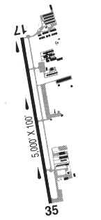
Runways
Runway Summary
| Runways: | 17/35 |
| Longest Runway: | 17/35 is 5003 ft (1525 m) long |
| Runways with an Instrument Approach: | 17 |
KUAO Airport Runway Details
| Runway 17/35 | 5003 ft x 100 ft (1525 m x 30 m) | |
| Runway Length Source: | 3RD PARTY SURVEY as of 08/20/2022 | |
| Surface: | Asphalt - Good condition - Saw-cut or plastic grooved | |
| Runway Edge Lights: | Medium Intensity | |
Runway Weight Bearing Capacity (in thousands of pounds) |
||
| Single Wheel Landing Gear: | 30.0 | |
| Dual Wheel Landing Gear: | 45.0 | |
Runway 17 |
Runway 35 |
|
Elevation: |
199.5 | 196.3 |
Latitude: |
45-15-14.1627N | 45-14-25.1473N |
Longitude: |
122-46-07.8231W | 122-46-16.5147W |
|
Runway True Alignment: |
187 | 007 |
ILS Type: |
LOC/DME | |
Glide Path Angle: |
3.5 degrees | 3.2 degrees |
Traffic Pattern: |
Left | Left |
Runway Markings Type: |
Precision Instrument | Precision Instrument |
Runway Markings Condition: |
Good | Good |
Object at End: |
TREES | TREE |
Object Height: |
100 | 90 |
Distance from End: |
2939 | 1634 |
Object Centerline Offset: |
175 ft. right of centerline | 520 ft. left of centerline |
Visual Glide Slope Indicators: |
4-Box VASI On Right Side Of Runway | 4-Box VASI On Left Side Of Runway |
Approach Light System: |
Omnidirectional Approach Lighting System | |
Threshold Crossing Height: |
38 | 51 |
Services
Airframe Repair: |
Major |
Powerplant Repair: |
Major |
Bottled Oxygen: |
High Pressure |
Bulk Oxygen: |
High Pressure / Low Pressure |
Fuel Available: |
100LL, Jet A |
Landing Fees: |
No |
Parking: |
Hangars and tiedowns available |
Maps & Diagrams
KUAO Sectional
Flight Planning
at skyvector.com
at skyvector.com