Location
Latitude: |
38-28-30.0830N (38.475023) |
Longitude: |
100-53-03.9800W (-100.884439) |
Elevation: |
2968.7 feet MSL (905 m MSL) |
Magnetic Variation: |
5.3 E (as of April 2024 from WMM2020 model) |
Time Zone: |
UTC -6.0 (Standard Time) UTC -5.0 (Daylight Savings Time) |
From City: |
01 N.M. SE of Scott City, Kansas |
Found On: |
Wichita Chart |
FAA Region: |
ACE |
Contacts
Manager: |
Publicly owned: |
| AL SIBI 300 SOUTH MESQUITE ROAD SCOTT CITY, KS 67871 (620) 872-5620 |
CITY OF SCOTT CITY 221 W. 5TH SCOTT CITY, KS 67871 620-872-5322 |
Operations
Airport Status: |
Operational |
Facility Use: |
Public |
Type: |
Airport |
Activation Date: |
12/1945 |
Control tower: |
No |
Attendance (Months/Days/Hours): |
Months/Days/Hours ALL/ALL/0800-1730 |
Boundary ARTCC: |
ZDV (Denver) |
Responsible ARTCC: |
ZDV (Denver) |
Lighting Schedule: |
SEE RMK |
Segmented Circle Indicator: |
Yes |
Traffic Pattern Altitude (MSL): |
3969 feet (1210 m) |
NOTAMs Facility: |
ICT |
NOTAM-D Service: |
Yes |
Civil/Military Joint Use: |
No |
Based Aircraft
| Single Engine: | 28 |
| Multi Engine: | 1 |
| GA Helicopters: | 2 |
Annual Operations (as of 09/24/2020)
| Total Operations: | 8000 | |
| GA Local: | 4800 | 60.0% |
| GA Itinerant: | 3200 | 40.0% |
Communications
| CTAF: | 122.800 |
| Unicom: | 122.800 |
| AWOS-3P: | 120.00 (620-872-2233) |
- APCH/DEP CTL SVC PRVDD BY DENVER ARTCC (ZDV) ON FREQS 132.7/226.675 (GOODLAND RCAG).
Fixed Based Operators (FBOs) & Fuel
(Click on a business for detail)
Please help us keep this information up to date. This is a FREE SERVICE just like everything else on Airport Guide! If you see that a business needs to be added, modified, or deleted please fill out our Update Form.
To add, modify, or delete a business click here.
Please help us keep this information up to date. This is a FREE SERVICE just like everything else on Airport Guide! If you see that a business needs to be added, modified, or deleted please fill out our Update Form.
Area Code: 620 |
| Business Name | Frequency | Phone | Fuel Grade |
|---|---|---|---|
| Scott City Aviation
Update FBO info |
Unicom 122.8 | 872-5378, 872-2522 | 100LL, Jet A |
Flight Service Stations
| Primary | Alternate | |
| FSS on Field: | N | |
| FSS Name (ID): | Wichita(ICT) | |
| Frequency: | ||
| Toll Free Phone: | 1-800-WX-BRIEF |
Instrument Procedures / Charts
FAA Terminal Procedures valid from 0901Z 03/21/24 to 0901Z 04/18/24.
There are various types of charts available for an airport. They are listed in the Page Type column. Here is a legend for those types:
APD - Airport Diagram
DP - Departure Procedure Charts
HOT - Hot Spots
IAP - Instrument Approach Procedure Charts
MIN - Minimums
STAR - Standard Terminal Arrival Charts
| Page Type | Page Name | Volume | Action Since Last Cycle |
|---|---|---|---|
| IAP | RNAV (GPS) RWY 17 | NC-2 | |
| IAP | RNAV (GPS) RWY 35 | NC-2 | |
| MIN | ALTERNATE MINIMUMS | NC-2 | |
| MIN | TAKEOFF MINIMUMS | NC-2 |
Terminal Procedures are only available for airports in several countries with more being added all the time. If you are looking for a specific country's charts, please send an email to support(at)airportguide.com stating the country name. This will be used to prioritize the implementation.
Navigation Aids (Navaids) near KTQK
| Dist (NM) | ID | Morse Code | Name | Type | Freq | True Hdg | Mag Hdg |
|---|---|---|---|---|---|---|---|
| 0.4 | TQK | _ _ _ . _ _ . _ | Scott City | NDB | 256 | 328 | 323 |
| 34.2 | GCK | _ _ . _ . _ . _ . _ | Garden City | VORTAC | 113.30 | 167 | 162 |
| 38.4 | OEL | _ _ _ . . _ . . | Oakley | NDB | 380 | 4 | 359 |
| 39.5 | GC | _ _ . _ . _ . | Pieve | NDB | 347 | 168 | 163 |
| 55.9 | DDC | _ . . _ . . _ . _ . | Dodge City | VORTAC | 108.20 | 131 | 126 |
| 56.2 | HLC | . . . . . _ . . _ . _ . | Hill City | VORTAC | 113.70 | 32 | 27 |
| 57.4 | ULS | . . _ . _ . . . . . | Ulysses | NDB | 395 | 203 | 198 |
| 59.4 | GL | _ _ . . _ . . | Shugr | NDB | 414 | 325 | 320 |
| 62.6 | JDM | . _ _ _ _ . . _ _ | Wheatfield | NDB | 408 | 353 | 348 |
| 64.4 | JHN | . _ _ _ . . . . _ . | Bear Creek | NDB | 341 | 218 | 213 |
| 66.5 | GLD | _ _ . . _ . . _ . . | Goodland | VORTAC | 115.10 | 325 | 319 |
| 78.6 | HY | . . . . _ . _ _ | Nette | NDB | 374 | 76 | 71 |
| 78.6 | HYS | . . . . _ . _ _ . . . | Hays | VORTAC | 110.40 | 72 | 67 |
| 80.1 | ITR | . . _ . _ . | Kit Carson | NDB | 209 | 305 | 299 |
| 82.0 | HQG | . . . . _ _ . _ _ _ . | Hugoton | NDB | 365 | 196 | 191 |
| 82.9 | OIN | _ _ _ . . _ . | Oberlin | NDB | 341 | 11 | 6 |
| 85.7 | SYF | . . . _ . _ _ . . _ . | St Francis | NDB | 386 | 331 | 325 |
| 85.9 | LBL | . _ . . _ . . . . _ . . | Liberal | TACAN | 112.30 | 182 | 177 |
| 86.1 | LQR | . _ . . _ _ . _ . _ . | Larned | NDB | 296 | 100 | 95 |
| 86.5 | LAA | . _ . . . _ . _ | Lamar | VOR-DME | 116.90 | 259 | 253 |
Nearby Airports with Fuel
Notices to Airmen (NOTAMS)
Remarks
| A110-1 | PUB TELEPHONE AVBL 24 HRS 620-872-5378 |
| A110-2 | NUMEROUS BIRDS INVOF ARPT. |
| A110-3 | FOR CD CTC DENVER ARTCC AT 303-651-4257. |
| A33-08/26 | ROUGH, WITH MULTIPLE RODENT HOLES. |
| A42-08 | 08/26 MKD WITH PAINTED TIRES. |
| A57-17 | CONTROLLING OBSTN EXCEEDS A 45 DEG SLP. |
| A81-APT | MIRL RWY 17/35 PRESET LOW INTST; TO INCR INTST & ACTVT REIL, PAPI RWYS 17 & 35 - CTAF. |
| E111 | HEL CONDS: PRVDD APCH/DEP PATHS TO LNDG AREA ARE MAINTD FOR MIN 8:1 GLIDE SLOPE & TRSNL SFCBE MAINTD FOR 2:1 SLOPE. |
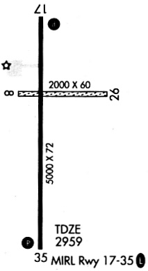
Runways
Runway Summary
| Runways: | 08/26 17/35 |
| Longest Runway: | 17/35 is 5002 ft (1525 m) long |
| Runways with an Instrument Approach: |
KTQK Airport Runway Details
| Runway 08/26 | 2145 ft x 60 ft (654 m x 18 m) | |
| Runway Length Source: | 3RD PARTY SURVEY as of 08/31/2020 | |
| Surface: | Turf - Good condition - No special surface treatment | |
Runway 08 |
Runway 26 |
|
Elevation: |
2960.3 | 2968.6 |
Latitude: |
38-28-36.2798N | 38-28-36.1575N |
Longitude: |
100-53-13.3412W | 100-52-46.3776W |
|
Runway True Alignment: |
090 | 270 |
Glide Path Angle: |
0.0 degrees | 0.0 degrees |
Traffic Pattern: |
Left | Left |
| Runway 17/35 | 5002 ft x 75 ft (1525 m x 23 m) | |
| Runway Length Source: | 3RD PARTY SURVEY as of 08/31/2020 | |
| Surface: | Turf - Good condition - No special surface treatment | |
| Runway Pavement Class: | 11 /R/C/X/U | |
| Runway Edge Lights: | Medium Intensity | |
Runway Weight Bearing Capacity (in thousands of pounds) |
||
| Single Wheel Landing Gear: | 30.0 | |
| Dual Wheel Landing Gear: | 45.0 | |
Runway 17 |
Runway 35 |
|
Elevation: |
2959.7 | 2956.1 |
Latitude: |
38-28-52.1692N | 38-28-02.7344N |
Longitude: |
100-53-06.1041W | 100-53-05.3903W |
|
Runway True Alignment: |
179 | 359 |
Glide Path Angle: |
3.0 degrees | 3.0 degrees |
Traffic Pattern: |
Left | Left |
Runway Markings Type: |
Nonprecision Instrument | Nonprecision Instrument |
Runway Markings Condition: |
Fair | Fair |
Object at End: |
ROAD | ROAD |
Object Height: |
15 | 10 |
Distance from End: |
530 | 201 |
Visual Glide Slope Indicators: |
2-Light PAPI On Left Side Of Runway | 2-Light PAPI On Left Side Of Runway |
REIL: |
Yes | Yes |
Threshold Crossing Height: |
38 | 38 |
Services
Airframe Repair: |
Major |
Powerplant Repair: |
Major |
Bottled Oxygen: |
Low Pressure |
Bulk Oxygen: |
Low Pressure |
Fuel Available: |
100LL, Jet A |
Landing Fees: |
No |
Parking: |
Hangars and tiedowns available |
Maps & Diagrams
KTQK Sectional
Flight Planning
at skyvector.com
at skyvector.com