Location
Latitude: |
38-42-02.7580N (38.700766) |
Longitude: |
087-07-52.6450W (-87.13129) |
Elevation: |
472.3 feet MSL (144 m MSL) |
Magnetic Variation: |
4.2 W (as of April 2024 from WMM2020 model) |
Time Zone: |
UTC -6.0 (Standard Time) UTC -5.0 (Daylight Savings Time) |
From City: |
03 N.M. NE of Washington, Indiana |
Found On: |
St Louis Chart |
FAA Region: |
AGL |
Contacts
Manager: |
Publicly owned: |
| ERICA BURKEMPER 1724 E 250 N WASHINGTON, IN 47501 812-698-0463 |
DAVIESS COUNTY BOAC P. O. BOX 2338 WASHINGTON, IN 47501 812-698-0463 |
Operations
Airport Status: |
Operational |
Facility Use: |
Public |
Type: |
Airport |
Activation Date: |
01/1965 |
Control tower: |
No |
Attendance (Months/Days/Hours): |
Months/Days/Hours ALL/MON-FRI/0800-1700 |
Boundary ARTCC: |
ZID (Indianapolis) |
Responsible ARTCC: |
ZID (Indianapolis) |
Lighting Schedule: |
SEE RMK |
Segmented Circle Indicator: |
Yes |
Traffic Pattern Altitude (MSL): |
1472 feet (449 m) |
NOTAMs Facility: |
HUF |
NOTAM-D Service: |
Yes |
International Airport of Entry: |
No |
Customs Landing Rights: |
No |
Military Landing Rights: |
Yes |
Civil/Military Joint Use: |
No |
Based Aircraft
| Single Engine: | 22 |
| Multi Engine: | 4 |
Annual Operations (as of 12/31/2019)
| Total Operations: | 2803 | |
| Air Taxi: | 29 | 1.0% |
| GA Local: | 2354 | 84.0% |
| GA Itinerant: | 420 | 15.0% |
Communications
| CTAF: | 122.800 |
| Unicom: | 122.800 |
| Approach: | EVANSVILLE 125.6 125.6 INDIANAPOLIS ARTCC |
| Departure: | EVANSVILLE 125.6 125.6 INDIANAPOLIS ARTCC |
| AWOS-3PT: | 119.075 (812-257-8889) |
- APCH/DEP SVC PRVDD BY INDIANAPOLIS ARTCC ON FREQS 128.3/291.625 (EVANSVILLE RCAG) WHEN EVANSVILLE APCH CTL CLSD.
Fixed Based Operators (FBOs) & Fuel
(Click on a business for detail)
Please help us keep this information up to date. This is a FREE SERVICE just like everything else on Airport Guide! If you see that a business needs to be added, modified, or deleted please fill out our Update Form.
To add, modify, or delete a business click here.
Please help us keep this information up to date. This is a FREE SERVICE just like everything else on Airport Guide! If you see that a business needs to be added, modified, or deleted please fill out our Update Form.
Area Code: 812 |
| Business Name | Frequency | Phone | Fuel Grade |
|---|---|---|---|
| Bill's Aero Service
Update FBO info |
Unicom 122.8 | 254-6222 | 100LL, Jet A |
Flight Service Stations
| Primary | Alternate | |
| FSS on Field: | N | |
| FSS Name (ID): | Terre Haute(HUF) | |
| Frequency: | ||
| Toll Free Phone: | 1-800-WX-BRIEF |
Instrument Procedures / Charts
FAA Terminal Procedures valid from 0901Z 03/21/24 to 0901Z 04/18/24.
There are various types of charts available for an airport. They are listed in the Page Type column. Here is a legend for those types:
APD - Airport Diagram
DP - Departure Procedure Charts
HOT - Hot Spots
IAP - Instrument Approach Procedure Charts
MIN - Minimums
STAR - Standard Terminal Arrival Charts
| Page Type | Page Name | Volume | Action Since Last Cycle |
|---|---|---|---|
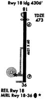
| IAP | RNAV (GPS) RWY 18 | EC-2 | Changed |
| MIN | ALTERNATE MINIMUMS | EC-2 | |
| MIN | TAKEOFF MINIMUMS | EC-2 |
Terminal Procedures are only available for airports in several countries with more being added all the time. If you are looking for a specific country's charts, please send an email to support(at)airportguide.com stating the country name. This will be used to prioritize the implementation.
Navigation Aids (Navaids) near KDCY
| Dist (NM) | ID | Morse Code | Name | Type | Freq | True Hdg | Mag Hdg |
|---|---|---|---|---|---|---|---|
| 19.9 | OEA | _ _ _ . . _ | Vincennes | NDB | 251 | 268 | 272 |
| 22.5 | LWV | . _ . . . _ _ . . . _ | Lawrenceville | DME | 108.8 | 280 | 284 |
| 28.2 | HNB | . . . . _ . _ . . . | Huntingburg | VOR-DME | 109.20 | 163 | 167 |
| 28.8 | SIV | . . . . . . . . _ | Sullivan | NDB | 326 | 329 | 333 |
| 30.4 | PLX | . _ _ . . _ . . _ . . _ | Palestine | NDB | 391 | 308 | 312 |
| 30.8 | RSV | . _ . . . . . . . _ | Robinson | VOR-DME | 108.40 | 308 | 312 |
| 33.6 | BFR | _ . . . . . _ . . _ . | Bedford | NDB | 344 | 75 | 79 |
| 35.9 | OOM | _ _ _ _ _ _ _ _ | Hoosier | VORTAC | 110.20 | 42 | 46 |
| 43.1 | HU | . . . . . . _ | Yinno | NDB | 245 | 343 | 347 |
| 43.9 | PDW | . _ _ . _ . . . _ _ | Evansville | NDB | 284 | 205 | 209 |
| 46.1 | TEL | _ . . _ . . | Tell City | NDB | 206 | 153 | 157 |
| 46.6 | SAM | . . . . _ _ _ | Samsville | DME | 116.6 | 254 | 258 |
| 47.6 | TTH | _ _ . . . . | Terre Haute | VORTAC | 115.30 | 353 | 357 |
| 48.8 | OLY | _ _ _ . _ . . _ . _ _ | Olney | NDB | 272 | 271 | 275 |
| 54.4 | CZB | _ . _ . _ _ . . _ . . . | Casey | NDB | 359 | 312 | 316 |
| 55.1 | PXV | . _ _ . _ . . _ . . . _ | Pocket City | VORTAC | 113.30 | 212 | 216 |
| 55.1 | EQZ | . _ _ . _ _ _ . . | Captain | NDB | 308 | 79 | 84 |
| 57.5 | OWB | _ _ _ . _ _ _ . . . | Owensboro | VOR-DME | 108.60 | 181 | 185 |
| 62.7 | TVX | _ . . . _ _ . . _ | Greencastle | NDB | 521 | 13 | 17 |
| 63.0 | FWC | . . _ . . _ _ _ . _ . | Wayne County | NDB | 257 | 252 | 256 |
Nearby Airports with Fuel
Notices to Airmen (NOTAMS)
Remarks
| A110-2 | FOR CD CTC EVANSVILLE APCH AT 812-436-4690, WHEN APCH CLSD CTC INDIANAPOLIS ARTCC AT 317-247-2411. |
| A110-3 | SELF SERVE FUEL AVBL. |
| A57-18 | APCH SLOPE 20:1 FM DTHR. |
| A58-36 | 10 FT CROPS 70 FT FM RWY END 75 FT L & R. |
| A81-APT | ACTVT REIL RWY 18 & 36; PAPI RWY 18 & 36; MIRL RWY 18/36 - CTAF. |
Runways
Runway Summary
| Runways: | 09/27 18/36 |
| Longest Runway: | 18/36 is 5001 ft (1524 m) long |
| Runways with an Instrument Approach: |
KDCY Airport Runway Details
| Runway 09/27 | 2651 ft x 150 ft (808 m x 46 m) | |
| Runway Length Source: | 3RD PARTY SURVEY as of 04/19/2022 | |
| Surface: | Turf - Fair condition - No special surface treatment | |
Runway 09 |
Runway 27 |
|
Elevation: |
470.5 | 466.5 |
Latitude: |
38-42-01.5296N | 38-42-01.5300N |
Longitude: |
087-08-19.9801W | 087-07-46.5442W |
|
Runway True Alignment: |
089 | 271 |
Glide Path Angle: |
0.0 degrees | 0.0 degrees |
Object at End: |
CROPS | |
Object Height: |
10 | |
Distance from End: |
201 | |
Object Centerline Offset: |
0 ft. left and right of centerline | |
Threshold Elevation: |
358.1 | |
Displaced Threshold: |
403 | |
Threshold Latitude: |
38-42-01.5299N | |
Threshold Longitude: |
087-07-51.6250W |
| Runway 18/36 | 5001 ft x 75 ft (1524 m x 23 m) | |
| Runway Length Source: | 3RD PARTY SURVEY as of 04/19/2022 | |
| Surface: | Turf - Fair condition - Saw-cut or plastic grooved | |
| Runway Edge Lights: | Medium Intensity | |
Runway Weight Bearing Capacity (in thousands of pounds) |
||
| Single Wheel Landing Gear: | 10.0 | |
| Dual Wheel Landing Gear: | 44.0 | |
Runway 18 |
Runway 36 |
|
Elevation: |
456.7 | 467.4 |
Latitude: |
38-42-28.1255N | 38-41-38.6912N |
Longitude: |
087-07-47.0209W | 087-07-47.0151W |
|
Runway True Alignment: |
180 | 360 |
Glide Path Angle: |
3.0 degrees | 3.0 degrees |
Traffic Pattern: |
Left | Left |
Runway Markings Type: |
Nonprecision Instrument | Nonprecision Instrument |
Runway Markings Condition: |
Fair | Fair |
Object at End: |
CROPS | CROPS |
Object Height: |
10 | 10 |
Distance from End: |
300 | 201 |
Object Centerline Offset: |
0 ft. left and right of centerline | |
Visual Glide Slope Indicators: |
2-Light PAPI On Left Side Of Runway | 2-Light PAPI On Left Side Of Runway |
REIL: |
Yes | Yes |
Touchdown Lights: |
No | No |
Centerline Lights: |
No | No |
Threshold Crossing Height: |
49 | 33 |
Services
Bottled Oxygen: |
None |
Bulk Oxygen: |
None |
Fuel Available: |
100LL, Jet A |
Landing Fees: |
No |
Parking: |
Hangars available |
Maps & Diagrams
KDCY Sectional
Flight Planning
at skyvector.com
at skyvector.com