Location
Latitude: |
26-26-01.3638N (26.433712) |
Longitude: |
081-24-01.7214W (-81.400478) |
Elevation: |
37.1 feet MSL (11 m MSL) |
Magnetic Variation: |
6.5 W (as of April 2024 from WMM2020 model) |
Time Zone: |
UTC -5.0 (Standard Time) UTC -4.0 (Daylight Savings Time) |
From City: |
01 N.M. NE of Immokalee, Florida |
Found On: |
Miami Chart |
FAA Region: |
ASO |
Contacts
Manager: |
Publicly owned: |
| NICK ROSSDALE 165 AIRPARK BLVD IMMOKALEE, FL 34142 239-252-6296 |
COLLIER COUNTY AIRPORT AUTHORITY 2005 MAINSAIL DR., SUITE 1 NAPLES, FL 34114 239-642-7878 |
Operations
Airport Status: |
Operational |
Facility Use: |
Public |
Type: |
Airport |
Activation Date: |
02/1944 |
Control tower: |
No |
Attendance (Months/Days/Hours): |
Months/Days/Hours ALL/ALL/0800-1800 |
Boundary ARTCC: |
ZMA (Miami) |
Responsible ARTCC: |
ZMA (Miami) |
Lighting Schedule: |
SEE RMK |
Segmented Circle Indicator: |
Yes, Lighted |
Traffic Pattern Altitude (MSL): |
1037 feet (316 m) |
NOTAMs Facility: |
MIA |
NOTAM-D Service: |
Yes |
International Airport of Entry: |
No |
Customs Landing Rights: |
No |
Military Landing Rights: |
Yes |
Civil/Military Joint Use: |
No |
Based Aircraft
| Single Engine: | 24 |
| Multi Engine: | 6 |
| GA Helicopters: | 1 |
Annual Operations (as of 02/28/2019)
| Total Operations: | 37850 | |
| GA Local: | 30500 | 80.6% |
| GA Itinerant: | 7200 | 19.0% |
| Military Aircraft: | 150 | 0.4% |
Communications
| CTAF: | 122.900 |
| Approach: | FORT MYERS 124.125 124.125 MIAMI ARTCC |
| Departure: | FORT MYERS 124.125 124.125 MIAMI ARTCC |
| AWOS-3: | 118.525 (239-657-2038) |
- APCH/DEP SVC PRVDD BY MIAMI ARTCC ON FREQS 134.75/322.5(FORT MYERS RCAG) WHEN FORT MYERS APCH CTL CLSD.
Fixed Based Operators (FBOs) & Fuel
(Click on a business for detail)
Please help us keep this information up to date. This is a FREE SERVICE just like everything else on Airport Guide! If you see that a business needs to be added, modified, or deleted please fill out our Update Form.
To add, modify, or delete a business click here.
Please help us keep this information up to date. This is a FREE SERVICE just like everything else on Airport Guide! If you see that a business needs to be added, modified, or deleted please fill out our Update Form.
Area Code: 941 |
| Business Name | Frequency | Phone | Fuel Grade |
|---|---|---|---|
| Airwork, Inc.
Update FBO info |
657-3217 | ||
| Immokalee Regional Airport
Update FBO info |
Unicom 122.9 | 657-9003 | 100LL, Jet A |
Flight Service Stations
| Primary | Alternate | |
| FSS on Field: | N | |
| FSS Name (ID): | Miami(MIA) | |
| Frequency: | ||
| Toll Free Phone: | 1-800-WX-BRIEF |
Instrument Procedures / Charts
FAA Terminal Procedures valid from 0901Z 03/21/24 to 0901Z 04/18/24.
There are various types of charts available for an airport. They are listed in the Page Type column. Here is a legend for those types:
APD - Airport Diagram
DP - Departure Procedure Charts
HOT - Hot Spots
IAP - Instrument Approach Procedure Charts
MIN - Minimums
STAR - Standard Terminal Arrival Charts
| Page Type | Page Name | Volume | Action Since Last Cycle |
|---|---|---|---|
| IAP | RNAV (GPS) RWY 09 | SE-3 | |
| IAP | RNAV (GPS) RWY 18 | SE-3 | |
| IAP | RNAV (GPS) RWY 27 | SE-3 | |
| IAP | RNAV (GPS) RWY 36 | SE-3 | |
| MIN | ALTERNATE MINIMUMS | SE-3 | |
| MIN | TAKEOFF MINIMUMS | SE-3 |
Terminal Procedures are only available for airports in several countries with more being added all the time. If you are looking for a specific country's charts, please send an email to support(at)airportguide.com stating the country name. This will be used to prioritize the implementation.
Navigation Aids (Navaids) near IMM
| Dist (NM) | ID | Morse Code | Name | Type | Freq | True Hdg | Mag Hdg |
|---|---|---|---|---|---|---|---|
| 21.0 | RSW | . _ . . . . . _ _ | Lee County | VORTAC | 114.15 | 286 | 292 |
| 23.7 | LBV | . _ . . _ . . . . . . _ | La Belle | VORTAC | 110.40 | 1 | 8 |
| 26.4 | CYY | _ . _ . _ . _ _ _ . _ _ | Cypress | VOR-DME | 108.60 | 230 | 236 |
| 29.9 | FM | . . _ . _ _ | Caloo | NDB | 341 | 279 | 285 |
| 40.2 | TN | _ _ . | Monry | NDB | 227 | 148 | 155 |
| 42.9 | PGD | . _ _ . _ _ . _ . . | Punta Gorda | VOR | 110.20 | 312 | 318 |
| 43.4 | PHK | . _ _ . . . . . _ . _ | Pahokee | VOR-DME | 115.40 | 61 | 68 |
| 61.1 | FX | . . _ . _ . . _ | Praiz | NDB | 221 | 103 | 110 |
| 63.8 | UTX | . . _ _ _ . . _ | United | NDB | 405 | 63 | 70 |
| 66.8 | VNC | . . . _ _ . _ . _ . | Venice | NDB | 206 | 304 | 310 |
| 67.7 | TM | _ _ _ | Qeezy | NDB | 266 | 134 | 141 |
| 68.2 | DHP | _ . . . . . . . _ _ . | Dolphin | VORTAC | 113.90 | 123 | 130 |
| 69.8 | FLL | . . _ . . _ . . . _ . . | Fort Lauderdale | VOR-DME | 114.40 | 107 | 114 |
| 71.2 | PBI | . _ _ . _ . . . . . | Palm Beach | VOT | 109.00 | 77 | 84 |
| 71.6 | MIA | _ _ . . . _ | Miami Intl | VOT | 112.00 | 122 | 129 |
| 72.1 | PBI | . _ _ . _ . . . . . | Palm Beach | VORTAC | 115.70 | 77 | 84 |
| 78.6 | VKZ | . . . _ _ . _ _ _ . . | Virginia Key | VOR-DME | 117.10 | 121 | 128 |
| 79.0 | HST | . . . . . . . _ | Homestead | TACAN | 108.20 | 135 | 142 |
| 83.7 | FPR | . . _ . . _ _ . . _ . | Fort Pierce | NDB | 275 | 40 | 47 |
| 85.3 | SRQ | . . . . _ . _ _ . _ | Sarasota | VOR-DME | 117.00 | 313 | 319 |
Nearby Airports with Fuel
Notices to Airmen (NOTAMS)
Remarks
| A110-1 | CROP DUSTING ACTVTY DURG DALGT HRS. |
| A110-6 | WILDLIFE, BANNER TOWING & ULTRALIGHT ACTVTY ON AND INVOF ARPT. |
| A110-8 | AFT HR SVC - AMGR. |
| A110-9 | FOR CD CTC FORT MYERS APCH AT 239-416-1026, WHEN APCH CLSD CTC MIAMI ARTCC AT 305-716-1731. |
| A70-FUEL-10 | 0LL CREDIT CARD FUEL AVBL H24. |
| A81-APT | ACTVT REIL RWY 9, 27, 18, & 36; MIRL RWY 09/27 & 18/36 - CTAF. |
| E111 | VFR ONLY |
Runways
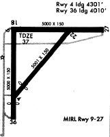
Runway Summary
| Runways: | 09/27 18/36 |
| Longest Runway: | 09/27 is 5000 ft (1524 m) long |
| Runways with an Instrument Approach: |
IMM Airport Runway Details
| Runway 09/27 | 5000 ft x 100 ft (1524 m x 30 m) | |
| Runway Length Source: | 3RD PARTY SURVEY as of 07/16/2015 | |
| Surface: | Asphalt - Good condition - No special surface treatment | |
| Runway Pavement Class: | 23 /F/A/X/T | |
| Runway Edge Lights: | Medium Intensity | |
Runway Weight Bearing Capacity (in thousands of pounds) |
||
| Single Wheel Landing Gear: | 68.0 | |
| Dual Wheel Landing Gear: | 97.0 | |
| Dual Tandem Wheel Landing Gear: | 110.0 | |
Runway 09 |
Runway 27 |
|
Elevation: |
37.1 | 34.0 |
Latitude: |
26-26-13.4767N | 26-26-15.1752N |
Longitude: |
081-24-14.6283W | 081-23-19.6537W |
|
Runway True Alignment: |
089 | 269 |
Glide Path Angle: |
3.0 degrees | 3.0 degrees |
Traffic Pattern: |
Left | Left |
Runway Markings Type: |
Nonprecision Instrument | Nonprecision Instrument |
Runway Markings Condition: |
Fair | Fair |
Object at End: |
TREES | TREES |
Object Height: |
21 | 12 |
Distance from End: |
920 | 695 |
Object Centerline Offset: |
285 ft. left of centerline | 250 ft. right of centerline |
Visual Glide Slope Indicators: |
4-Light PAPI On Left Side Of Runway | 4-Light PAPI On Left Side Of Runway |
REIL: |
Yes | Yes |
Threshold Crossing Height: |
52 | 53 |
| Runway 18/36 | 4550 ft x 150 ft (1387 m x 46 m) | |
| Runway Length Source: | 3RD PARTY SURVEY as of 07/16/2015 | |
| Surface: | Asphalt - Good condition - No special surface treatment | |
| Runway Pavement Class: | 8 /F/B/Y/T | |
| Runway Edge Lights: | Medium Intensity | |
Runway Weight Bearing Capacity (in thousands of pounds) |
||
| Single Wheel Landing Gear: | 27.0 | |
| Dual Wheel Landing Gear: | 42.0 | |
| Dual Tandem Wheel Landing Gear: | 90.0 | |
Runway 18 |
Runway 36 |
|
Elevation: |
35.9 | 33.3 |
Latitude: |
26-26-09.6375N | 26-25-24.6019N |
Longitude: |
081-24-18.6077W | 081-24-16.8798W |
|
Runway True Alignment: |
178 | 358 |
Glide Path Angle: |
3.0 degrees | 3.0 degrees |
Traffic Pattern: |
Left | Left |
Runway Markings Type: |
Nonprecision Instrument | Nonprecision Instrument |
Runway Markings Condition: |
Good | Good |
Object at End: |
TREES | TREE |
Object Height: |
19 | 42 |
Distance from End: |
900 | 1875 |
Object Centerline Offset: |
285 ft. left of centerline | 250 ft. right of centerline |
Visual Glide Slope Indicators: |
4-Light PAPI On Left Side Of Runway | 4-Light PAPI On Left Side Of Runway |
REIL: |
Yes | Yes |
Threshold Crossing Height: |
52 | 52 |
Services
Airframe Repair: |
Minor |
Powerplant Repair: |
Minor |
Bottled Oxygen: |
None |
Bulk Oxygen: |
None |
Fuel Available: |
100LL |
Landing Fees: |
No |
Parking: |
Tiedowns available |
Maps & Diagrams
IMM Sectional
Flight Planning
at skyvector.com
at skyvector.com