Location
Latitude: |
43-34-55.2650N (43.582018) |
Longitude: |
096-44-30.9310W (-96.741925) |
Elevation: |
1430.0 feet MSL (436 m MSL) |
Magnetic Variation: |
2.7 E (as of April 2024 from WMM2020 model) |
Time Zone: |
UTC -6.0 (Standard Time) UTC -5.0 (Daylight Savings Time) |
From City: |
03 N.M. NW of Sioux Falls, South Dakota |
Found On: |
Omaha Chart |
FAA Region: |
AGL |
Contacts
Manager: |
Publicly owned: |
| DANIEL J. LETELLIER 2801 JAYCEE LANE SIOUX FALLS, SD 57104 605-336-0762 |
SIOUX FALLS REGNL ARPT AUTH 2801 JAYCEE LANE SIOUX FALLS, SD 57104 605-336-0762 |
Operations
Airport Status: |
Operational |
Facility Use: |
Public |
Type: |
Airport |
Activation Date: |
11/1938 |
Control tower: |
Yes |
Attendance (Months/Days/Hours): |
Months/Days/Hours ALL/ALL/ALL |
Boundary ARTCC: |
ZMP (Minneapolis) |
Responsible ARTCC: |
ZMP (Minneapolis) |
Lighting Schedule: |
SEE RMK |
Segmented Circle Indicator: |
Yes |
Traffic Pattern Altitude (MSL): |
2430 feet (741 m) |
NOTAMs Facility: |
FSD |
NOTAM-D Service: |
Yes |
International Airport of Entry: |
No |
Customs Landing Rights: |
Yes |
Military Landing Rights: |
Yes |
Civil/Military Joint Use: |
No |
Aircraft Rescue and Firefighting: |
Class I ARFF Index: B Air Carrier Service: Scheduled Certification Date: 05/1973 |
Based Aircraft
| Single Engine: | 55 |
| Multi Engine: | 34 |
| Jet Engine: | 4 |
| Military Aircraft: | 18 |
Annual Operations (as of 12/31/2019)
| Total Operations: | 69691 | |
| Commercial: | 13584 | 19.5% |
| Air Taxi: | 21388 | 30.7% |
| GA Local: | 6261 | 9.0% |
| GA Itinerant: | 23474 | 33.7% |
| Military Aircraft: | 4984 | 7.2% |
Communications
| CTAF: | 118.300 |
| Unicom: | 122.950 |
| Tower: | SIOUX FALLS 118.3 257.8 Hrs: 0500-0000 |
| Ground: | 121.9 348.6 |
| Approach: | SIOUX FALLS 125.8 306.2 Hrs: 0500-0000 MINNEAPOLIS ARTCC 126.9 353.6 Hrs: 0000-0500 |
| Departure: | SIOUX FALLS 125.8 306.2 Hrs: 0500-0000 MINNEAPOLIS ARTCC 126.9 353.6 Hrs: 0000-0500 |
| ATIS: | 126.6 Hrs: 24 |
| ASOS: | (605-331-7833) |
| EMERG: | 121.5 |
| COMD POST: | 36.85FM |
| OPS: | 390.1 ;BASE MAINT |
| COMD POST: | 138.25 |
| EMERG: | 243.0 |
| COMD POST: | 253.4 |
- APCH/DEP SVC PRVDD BY MINNEAPOLIS ARTCC ON FREQ 132.050/317.4 (SIOUX FALLS RCAG) WHEN SIOUX FALLS APCH CTL IS CLSD.
- BASE COMMAND POST CALL (CLARENCE 49).
Fixed Based Operators (FBOs) & Fuel
(Click on a business for detail)
Please help us keep this information up to date. This is a FREE SERVICE just like everything else on Airport Guide! If you see that a business needs to be added, modified, or deleted please fill out our Update Form.
To add, modify, or delete a business click here.
Please help us keep this information up to date. This is a FREE SERVICE just like everything else on Airport Guide! If you see that a business needs to be added, modified, or deleted please fill out our Update Form.
Area Code: 605 |
| Business Name | Frequency | Phone | Fuel Grade |
|---|---|---|---|
| Business Aviation
Update FBO info |
Unicom 122.95 | 800-888-1646, 336-7791 | 100LL, Jet A |
| Business Aviation Courier
Update FBO info |
Unicom 122.95 | 336-9016, -7791 | |
| Signature Flight Support
Update FBO info |
Unicom: 122.95 | +1 605 336 7791 |
Flight Service Stations
| Primary | Alternate | |
| FSS on Field: | N | |
| FSS Name (ID): | Huron(HON) | |
| Frequency: | ||
| Toll Free Phone: | 1-800-WX-BRIEF |
Instrument Procedures / Charts
FAA Terminal Procedures valid from 0901Z 03/21/24 to 0901Z 04/18/24.
There are various types of charts available for an airport. They are listed in the Page Type column. Here is a legend for those types:
APD - Airport Diagram
DP - Departure Procedure Charts
HOT - Hot Spots
IAP - Instrument Approach Procedure Charts
MIN - Minimums
STAR - Standard Terminal Arrival Charts
| Page Type | Page Name | Volume | Action Since Last Cycle |
|---|---|---|---|
| APD | AIRPORT DIAGRAM | NC-1 | |
| IAP | HI-ILS OR LOC RWY 03 | NC-1 | |
| IAP | HI-ILS OR LOC RWY 21 | NC-1 | |
| IAP | HI-TACAN RWY 15 | NC-1 | |
| IAP | ILS OR LOC RWY 03 | NC-1 | |
| IAP | ILS OR LOC RWY 21 | NC-1 | |
| IAP | RNAV (GPS) RWY 03 | NC-1 | |
| IAP | RNAV (GPS) RWY 09 | NC-1 | Changed |
| IAP | RNAV (GPS) RWY 15 | NC-1 | |
| IAP | RNAV (GPS) RWY 21 | NC-1 | |
| IAP | RNAV (GPS) RWY 27 | NC-1 | |
| IAP | RNAV (GPS) RWY 33 | NC-1 | |
| IAP | VOR OR TACAN RWY 15 | NC-1 | |
| IAP | VOR/DME OR TACAN RWY 33 | NC-1 | |
| MIN | ALTERNATE MINIMUMS | NC-1 | Changed |
| MIN | RADAR MINIMUMS | NC-1 | |
| MIN | TAKEOFF MINIMUMS | NC-1 |
Terminal Procedures are only available for airports in several countries with more being added all the time. If you are looking for a specific country's charts, please send an email to support(at)airportguide.com stating the country name. This will be used to prioritize the implementation.
Navigation Aids (Navaids) near FSD
| Dist (NM) | ID | Morse Code | Name | Type | Freq | True Hdg | Mag Hdg |
|---|---|---|---|---|---|---|---|
| 4.4 | FSD | . . _ . . . . _ . . | Sioux Falls | VORTAC | 115.00 | 337 | 334 |
| 6.5 | FS | . . _ . . . . | Rokky | NDB | 245 | 215 | 212 |
| 29.9 | MDS | _ _ _ . . . . . | Wentworth | NDB | 400 | 330 | 327 |
| 36.1 | SOY | . . . _ _ _ _ . _ _ | Sioux Center | NDB | 368 | 138 | 136 |
| 43.4 | BKX | _ . . . _ . _ _ . . _ | Brookings | VOR-DME | 108.80 | 355 | 352 |
| 45.0 | ISB | . . . . . _ . . . | Sibley | NDB | 269 | 106 | 104 |
| 45.3 | SHL | . . . . . . . . _ . . | Sheldon | NDB | 338 | 118 | 116 |
| 46.4 | ORC | _ _ _ . _ . _ . _ . | Orange City | NDB | 521 | 139 | 137 |
| 47.2 | BK | _ . . . _ . _ | Chrlz | NDB | 335 | 349 | 346 |
| 48.7 | YKN | _ . _ _ _ . _ _ . | Yankton | DME | 111.4 | 215 | 212 |
| 50.5 | OTG | _ _ _ _ _ _ . | Worthington | DME | 110.6 | 85 | 83 |
| 50.6 | YK | _ . _ _ _ . _ | Cagur | NDB | 347 | 209 | 206 |
| 55.6 | OT | _ _ _ _ | Wondd | NDB | 277 | 87 | 85 |
| 57.4 | MHE | _ _ . . . . . | Mitchell | VOR-DME | 109.20 | 282 | 279 |
| 65.1 | SP | . . . . _ _ . | Snore | NDB | 394 | 108 | 106 |
| 65.3 | MML | _ _ _ _ . _ . . | Marshall | VOR-DME | 111.00 | 36 | 34 |
| 65.8 | GB | _ _ . _ . . . | Garno | NDB | 253 | 32 | 30 |
| 68.4 | OI | _ _ _ . . | Tommi | NDB | 305 | 169 | 166 |
| 71.8 | SPW | . . . . _ _ . . _ _ | Spencer | VOR-DME | 115.15 | 110 | 108 |
| 72.1 | GAK | _ _ . . _ _ . _ | Sioux Gateway | NDB | 233 | 167 | 164 |
Nearby Airports with Fuel
Notices to Airmen (NOTAMS)
Remarks
| A110-1 | MIGRATORY BIRDS WITHIN 25 NM PRIMARILY BETWEEN MAR-NOV. |
| A110-10 | EAST GA RAMP RESTRICTED TO 60,000 LBS. |
| A110-12 | ATCT HAS LIMITED VIS ON TWYS HOTEL, GOLF AND JULIET BTN THE EAST CARGO RAMP AND TWY BRAVO. |
| A110-13 | BE ALERT: MARV SKIE-LINCOLN COUNTY AIRPORT (Y14) LOCATED 7.2 MILES SW OF FSD & 2 MILES EAST OF ROKKY HAS HEAVY VFR TRAFFIC. |
| A110-16 | ANG: NUMEROUS NSTD MRK ON THE ANG PRK APRON. COMSEC STORAGE UNAVBL.BASH PHASE II OPS EFF MAR-APR, SEP-OCT; EXP INCR BIRD ACT; CTC ANG BASE OPS. |
| A110-17 | MILITARY: SVC: FUEL: A++, A++100 CTC ANG DSN 798-7754, C605-988-5754. |
| A110-18 | TWY C CLSD EXCEPT MIL ACFT. |
| A110-19 | SFC CONDS NOT MONITORED 0000-0430 HRS LCL. |
| A110-2 | WATERFOWL, BIRDS & DEER ON & INVOF ARPT. |
| A110-20 | TWY C CLSD EXCEPT MIL ACFT. |
| A110-21 | RWY 15/33 AND 3/21 A-GEAR NOT NMLLY UP. RQR 30 MIN PN, ONLY AVBL DRG NML ANG DUTY HR (OCT - APR). |
| A110-22 | FOR CD WHEN ATCT CLSD, CTC FSS. IF UNA, CTC MINNEAPOLIS ARTCC AT 651-463-5588. |
| A110-23 | COLD TEMPERATURE AIRPORT. ALTITUDE CORRECTION REQUIRED AT OR BELOW -31C. |
| A110-8 | FLT NOTIFICATION SVC (ADCUS) AVBL MON-FRI 0800-1600 CALL (605) 338-4384; AFT HRS CALL (605) 373-3523 PRIOR TO DEP. |
| A30-09/27 | RWY 9/27 NOT AVBL FOR SKEDD ACR OPNS WITH MORE THAN 9 PSGR SEATS OR UNSKEDD ACR AT LEAST 31 PSGR SEATS EXCP FOR TAXI. |
| A43-15 | PAPI UNUSBL BYD 6 DEGS LEFT AND 5 DEGS RIGHT OF CNTRLN. |
| A43-33 | PAPI UNUSBL BYD 9 DEGS RIGHT OF CNTRLN. |
| A52-15 | ALSO LGTD TWR; 4962 FM RY END; 159 ABV RY END; 893 R OF CNTRLN; 29:1 SLOPE. |
| A81-APT | ACTVT MALSR RWY 03 & 21; REIL RWY 15 & 33; HIRL RWY 03/21 & 15/33; MIRL RWY 9/27. WHEN ATCT CLSD MALSR RWY 03 & 21 PRESET ON LOW INTST, TO INCR INTST - CTAF. PAPI RWY 03, 21, 15, 33 OPR CONSLY. |
| E60-03 | BAK-14 BAK-12B(B) (1540'). |
| E60-15 | BAK-14 BAK-12B(B) (1550'). |
| E60-21 | BAK-14 BAK-12B(B) (1500'). |
| E60-33 | BAK-14 BAK-12B(B) (1500'). |
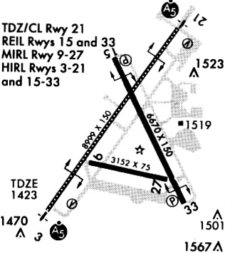
Runways
Runway Summary
| Runways: | 03/21 09/27 15/33 H1 |
| Longest Runway: | 03/21 is 9000 ft (2743 m) long |
| Runways with an Instrument Approach: | 03, 21 |
FSD Airport Runway Details
| Runway 03/21 | 9000 ft x 150 ft (2743 m x 46 m) | |
| Runway Length Source: | 3RD PARTY SURVEY as of 02/25/2022 | |
| Surface: | Concrete - Good condition - Saw-cut or plastic grooved | |
| Runway Pavement Class: | 60 /R/B/W/T | |
| Runway Edge Lights: | High Intensity | |
Runway Weight Bearing Capacity (in thousands of pounds) |
||
| Single Wheel Landing Gear: | 200.0 | |
| Dual Wheel Landing Gear: | 200.0 | |
| Dual Tandem Wheel Landing Gear: | 444.0 | |
Runway 03 |
Runway 21 |
|
Elevation: |
1423.5 | 1430.0 |
Latitude: |
43-34-21.4214N | 43-35-34.3156N |
Longitude: |
096-45-13.3350W | 096-44-03.3848W |
|
Runway True Alignment: |
035 | 215 |
ILS Type: |
ILS | ILS |
Glide Path Angle: |
3.0 degrees | 3.0 degrees |
Traffic Pattern: |
Left | Left |
Runway Markings Type: |
Precision Instrument | Precision Instrument |
Runway Markings Condition: |
Good | Good |
Arresting Device: |
BAK-12 | BAK-12 |
Object at End: |
ROAD | RR |
Object Height: |
8 | 27 |
Distance from End: |
283 | 1178 |
Object Centerline Offset: |
511 ft. left of centerline | 645 ft. right of centerline |
Visual Glide Slope Indicators: |
4-Light PAPI On Left Side Of Runway | 4-Light PAPI On Left Side Of Runway |
Runway Visual Range (RVR): |
Touchdown | Touchdown |
Approach Light System: |
1,400 Foot Medium Intensity Approach Lighting System With Runway Alignment Indicator Lights | 1,400 Foot Medium Intensity Approach Lighting System With Runway Alignment Indicator Lights |
REIL: |
No | No |
Touchdown Lights: |
No | Yes |
Centerline Lights: |
Yes | Yes |
Threshold Crossing Height: |
54 | 49 |
Declared Distances |
||
Take Off Run Avbl. (TORA): |
8999 | 8999 |
Take Off Distance Avbl. (TODA): |
8999 | 8999 |
Actual Stop Dist. Avbl. (ASDA): |
8999 | 8999 |
Landing Dist. Avbl. (LDA): |
8999 | 8999 |
| Runway 09/27 | 3151 ft x 75 ft (960 m x 23 m) | |
| Runway Length Source: | 3RD PARTY SURVEY as of 02/25/2022 | |
| Surface: | Concrete - Good condition - Wire comb or wire tine | |
| Runway Pavement Class: | 60 /R/B/W/T | |
| Runway Edge Lights: | Medium Intensity | |
Runway Weight Bearing Capacity (in thousands of pounds) |
||
| Single Wheel Landing Gear: | 30.0 | |
Runway 09 |
Runway 27 |
|
Elevation: |
1422.6 | 1421.9 |
Latitude: |
43-34-40.6822N | 43-34-33.5844N |
Longitude: |
096-44-51.1432W | 096-44-09.4646W |
|
Runway True Alignment: |
103 | 283 |
Glide Path Angle: |
0.0 degrees | 0.0 degrees |
Traffic Pattern: |
Left | Left |
Runway Markings Type: |
Basic | Basic |
Runway Markings Condition: |
Good | Good |
Object at End: |
TREE | POLE |
Object Height: |
71 | 149 |
Distance from End: |
2550 | 4620 |
Object Centerline Offset: |
511 ft. left of centerline | 645 ft. right of centerline |
REIL: |
No | No |
Touchdown Lights: |
No | No |
Centerline Lights: |
No | No |
| Runway 15/33 | 8000 ft x 150 ft (2438 m x 46 m) | |
| Runway Length Source: | 3RD PARTY SURVEY as of 11/21/2022 | |
| Surface: | Concrete - Good condition - Saw-cut or plastic grooved | |
| Runway Pavement Class: | 70 /R/B/W/T | |
| Runway Edge Lights: | High Intensity | |
Runway Weight Bearing Capacity (in thousands of pounds) |
||
| Single Wheel Landing Gear: | 100.0 | |
| Dual Wheel Landing Gear: | 180.0 | |
| Dual Tandem Wheel Landing Gear: | 400.0 | |
Runway 15 |
Runway 33 |
|
Elevation: |
1429.2 | 1422.4 |
Latitude: |
43-35-35.2597N | 43-34-23.6921N |
Longitude: |
096-44-45.8317W | 096-43-59.8019W |
|
Runway True Alignment: |
155 | 335 |
Glide Path Angle: |
3.0 degrees | 3.0 degrees |
Traffic Pattern: |
Left | Left |
Runway Markings Type: |
Nonprecision Instrument | Nonprecision Instrument |
Runway Markings Condition: |
Good | Good |
Arresting Device: |
BAK-12 | BAK-12 |
Object at End: |
TREE | TREE |
Object Height: |
109 | 47 |
Distance from End: |
3786 | 1455 |
Object Centerline Offset: |
511 ft. left of centerline | 645 ft. right of centerline |
Visual Glide Slope Indicators: |
4-Light PAPI On Left Side Of Runway | 4-Light PAPI On Left Side Of Runway |
REIL: |
Yes | Yes |
Touchdown Lights: |
No | No |
Centerline Lights: |
No | No |
Threshold Crossing Height: |
48 | 45 |
Declared Distances |
||
Take Off Run Avbl. (TORA): |
8000 | 8000 |
Take Off Distance Avbl. (TODA): |
8000 | 8000 |
Actual Stop Dist. Avbl. (ASDA): |
8000 | 8000 |
Landing Dist. Avbl. (LDA): |
8000 | 8000 |
| Helipad H1 | 50 ft x 50 ft (15 m x 15 m) | |
| Surface: | Concrete - Good condition - No special surface treatment | |
| Runway Edge Lights: | Perimeter lights (for helipads) Intensity | |
Helipad H1 |
||
Glide Path Angle: |
0.0 degrees | 0.0 degrees |
Object Centerline Offset: |
511 ft. left of centerline | 645 ft. right of centerline |
Services
Airframe Repair: |
Major |
Powerplant Repair: |
Major |
Fuel Available: |
100LL, Jet A |
Landing Fees: |
No |
Parking: |
Hangars and tiedowns available |
Maps & Diagrams
FSD Sectional
Flight Planning
at skyvector.com
at skyvector.com