Location
Latitude: |
36-44-28.5040N (36.741251) |
Longitude: |
108-13-47.7900W (-108.229942) |
Elevation: |
5506.6 feet MSL (1678 m MSL) |
Magnetic Variation: |
8.8 E (as of April 2024 from WMM2020 model) |
Time Zone: |
UTC -7.0 (Standard Time) UTC -6.0 (Daylight Savings Time) |
From City: |
01 N.M. NW of Farmington, New Mexico |
Found On: |
Denver Chart |
FAA Region: |
ASW |
Contacts
Manager: |
Publicly owned: |
| MICHAEL LEWIS 800 MUNICIPAL DRIVE FARMINGTON, NM 87401 505-599-1394 |
CITY OF FARMINGTON 800 MUNICIPAL DRIVE FARMINGTON, NM 87401 505-599-1100 |
Operations
Airport Status: |
Operational |
Facility Use: |
Public |
Type: |
Airport |
Control tower: |
Yes |
Attendance (Months/Days/Hours): |
Months/Days/Hours ALL/ALL/0600-2200 |
Boundary ARTCC: |
ZDV (Denver) |
Responsible ARTCC: |
ZDV (Denver) |
Lighting Schedule: |
SEE RMK |
Segmented Circle Indicator: |
Yes |
Traffic Pattern Altitude (MSL): |
6507 feet (1983 m) |
NOTAMs Facility: |
FMN |
NOTAM-D Service: |
Yes |
International Airport of Entry: |
No |
Customs Landing Rights: |
No |
Military Landing Rights: |
Yes |
Civil/Military Joint Use: |
No |
Aircraft Rescue and Firefighting: |
Class III ARFF Index: A Air Carrier Service: Scheduled Certification Date: 05/1973 |
Based Aircraft
| Single Engine: | 90 |
| Multi Engine: | 12 |
| Jet Engine: | 1 |
| GA Helicopters: | 4 |
| Gliders: | 1 |
| Ultralights: | 3 |
Annual Operations (as of 04/30/2022)
| Total Operations: | 45989 | |
| Air Taxi: | 5914 | 12.9% |
| GA Local: | 25550 | 55.6% |
| GA Itinerant: | 13373 | 29.1% |
| Military Aircraft: | 1152 | 2.5% |
Communications
| CTAF: | 118.900 |
| Unicom: | 122.950 |
| Tower: | FARMINGTON 118.9 257.8 Hrs: 0600-2200 |
| Ground: | 121.7 |
| Approach: | DENVER ARTCC |
| Departure: | DENVER ARTCC |
| ATIS: | 127.15 Hrs: 24 |
| ASOS: | 127.15 (505-325-9268) |
| EMERG: | 121.5 |
| EMERG: | 243.0 |
- APCH/DEP CTL SVC PRVDD BY DENVER ARTCC (ZDV) ON FREQS 118.575/348.7 (FARMINGTON RCAG).
- ATCT LEASED TO CITY OF FARMINGTON AND OPERATED BY MIDWEST ATC SERVICE INC.
Fixed Based Operators (FBOs) & Fuel
(Click on a business for detail)
Please help us keep this information up to date. This is a FREE SERVICE just like everything else on Airport Guide! If you see that a business needs to be added, modified, or deleted please fill out our Update Form.
To add, modify, or delete a business click here.
Please help us keep this information up to date. This is a FREE SERVICE just like everything else on Airport Guide! If you see that a business needs to be added, modified, or deleted please fill out our Update Form.
Area Code: 505 |
| Business Name | Frequency | Phone | Fuel Grade |
|---|---|---|---|
| Flight Proficiency
Update FBO info |
325-5613 | ||
| Four Corners Aviation
Update FBO info |
Unicom 122.95 | 325-2867 | 100LL, Jet A, Mogas |
Flight Service Stations
| Primary | Alternate | |
| FSS on Field: | N | |
| FSS Name (ID): | Albuquerque(ABQ) | |
| Frequency: | ||
| Toll Free Phone: | 1-800-WX-BRIEF |
Instrument Procedures / Charts
FAA Terminal Procedures valid from 0901Z 03/21/24 to 0901Z 04/18/24.
There are various types of charts available for an airport. They are listed in the Page Type column. Here is a legend for those types:
APD - Airport Diagram
DP - Departure Procedure Charts
HOT - Hot Spots
IAP - Instrument Approach Procedure Charts
MIN - Minimums
STAR - Standard Terminal Arrival Charts
| Page Type | Page Name | Volume | Action Since Last Cycle |
|---|---|---|---|
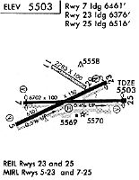
| APD | AIRPORT DIAGRAM | SW-1 | |
| DP | CHACO ONE | SW-1 | |
| DP | PLATA ONE | SW-1 | |
| IAP | ILS OR LOC RWY 25 | SW-1 | |
| IAP | RNAV (GPS) RWY 05 | SW-1 | |
| IAP | RNAV (GPS) RWY 07 | SW-1 | |
| IAP | RNAV (GPS) RWY 23 | SW-1 | |
| IAP | RNAV (GPS) RWY 25 | SW-1 | |
| IAP | VOR RWY 25 | SW-1 | |
| IAP | VOR/DME RWY 05 | SW-1 | |
| IAP | VOR/DME RWY 07 | SW-1 | |
| MIN | ALTERNATE MINIMUMS | SW-1 | |
| MIN | TAKEOFF MINIMUMS | SW-1 |
Terminal Procedures are only available for airports in several countries with more being added all the time. If you are looking for a specific country's charts, please send an email to support(at)airportguide.com stating the country name. This will be used to prioritize the implementation.
Navigation Aids (Navaids) near FMN
| Dist (NM) | ID | Morse Code | Name | Type | Freq | True Hdg | Mag Hdg |
|---|---|---|---|---|---|---|---|
| 6.3 | RSK | . _ . . . . _ . _ | Rattlesnake | VORTAC | 115.30 | 86 | 77 |
| 33.8 | DRO | _ . . . _ . _ _ _ | Durango | VOR-DME | 116.55 | 42 | 33 |
| 42.0 | CEZ | _ . _ . . _ _ . . | Cortez | VOR-DME | 114.35 | 337 | 328 |
| 72.3 | DVC | _ . . . . . _ _ . _ . | Dove Creek | VORTAC | 114.60 | 332 | 323 |
| 76.3 | AWR | . _ . _ _ . _ . | Window Rock | NDB | 254 | 212 | 203 |
| 78.0 | ETL | . _ . _ . . | Cones | VOR-DME | 110.20 | 359 | 350 |
| 82.1 | GUP | _ _ . . . _ . _ _ . | Gallup | VORTAC | 115.10 | 202 | 193 |
Nearby Airports with Fuel
| Dist (NM) | Name (Airport IDs) | True Hdg | Mag Hdg | Fuel Grade |
|---|---|---|---|---|
| 32.7 | Animas Air Park Airport (AMK 00C) |
31 | 22 | 100LL, Jet A |
| 33.6 | Durango-La Plata County Airport (DRO KDRO DRO) |
42 | 33 | 100LL, Jet A |
| 38.7 | Cortez Municipal Airport (CEZ KCEZ CEZ) |
330 | 321 | 100LL, Jet A |
| 65.1 | Stevens Field Airport (PGO KPSO PSO) |
59 | 51 | 100LL, Jet A |
| 74.3 | Telluride Regional Airport (TEX KTEX TEX) |
11 | 2 | 100LL, Jet A |
| 76.9 | Window Rock Airport (KRQE RQE) |
212 | 203 | 100LL |
| 78.4 | Blanding Municipal Airport (BDG KBDG BDG) |
310 | 301 | 100LL, Jet A |
| 78.6 | Gallup Municipal Airport (GUP KGUP GUP) |
200 | 191 | 100LL, Jet A-1+ |
| 89.0 | Monticello Airport (U64) |
323 | 314 | 100LL, Jet A |
| 91.3 | Hopkins Field Airport (KAIB AIB) |
350 | 341 | 100LL, Jet A |
| 95.8 | Grants-Milan Municipal Airport (GNT KGNT GNT) |
170 | 162 | 100LL, Jet A-1+ |
Notices to Airmen (NOTAMS)
Remarks
| A110-1 | FOR CD CTC FARMINGTON ATCT GROUND CONTROL 121.7, WHEN ATCT CLSD CTC DENVER ARTCC AT 303-651-4257 |
| A110-2 | ARPT SURFACE CONDITIONS ARE NOT MONITORED OUTSIDE OF ATTENDED HOURS. |
| A81-APT | WHEN ATCT CLSD ACTVT REIL RWY 23 & 25; PAPI RWY 05 & 23; VASI RWY 07 & 25; MIRL RWY 05/23 & 07/25 - CTAF. REIL RWY 25 & MIRL RWY 07/25 PRESET LOW INTST. |
Runways
Runway Summary
| Runways: | 05/23 07/25 |
| Longest Runway: | 07/25 is 6704 ft (2043 m) long |
| Runways with an Instrument Approach: | 25 |
FMN Airport Runway Details
| Runway 05/23 | 6501 ft x 150 ft (1982 m x 46 m) | |
| Runway Length Source: | 3RD PARTY SURVEY as of 06/03/2020 | |
| Surface: | Asphalt - Excellent condition - Saw-cut or plastic grooved | |
| Runway Pavement Class: | 29 /F/C/X/T | |
| Runway Edge Lights: | Medium Intensity | |
Runway Weight Bearing Capacity (in thousands of pounds) |
||
| Single Wheel Landing Gear: | 47.0 | |
| Dual Wheel Landing Gear: | 66.0 | |
Runway 05 |
Runway 23 |
|
Elevation: |
5471.6 | 5503.7 |
Latitude: |
36-44-14.3270N | 36-44-41.8322N |
Longitude: |
108-14-29.2361W | 108-13-17.0682W |
|
Runway True Alignment: |
065 | 245 |
Glide Path Angle: |
3.0 degrees | 3.0 degrees |
Traffic Pattern: |
Left | Left |
Runway Markings Type: |
Nonprecision Instrument | Nonprecision Instrument |
Runway Markings Condition: |
Good | Good |
Visual Glide Slope Indicators: |
4-Light PAPI On Left Side Of Runway | 4-Light PAPI On Right Side Of Runway |
REIL: |
Yes | |
Threshold Crossing Height: |
42 | 42 |
Threshold Elevation: |
5504.2 | |
Displaced Threshold: |
511 | |
Threshold Latitude: |
36-44-39.6708N | |
Threshold Longitude: |
108-13-22.7421W | |
Declared Distances |
||
Take Off Run Avbl. (TORA): |
6501 | 6501 |
Take Off Distance Avbl. (TODA): |
6501 | 6501 |
Actual Stop Dist. Avbl. (ASDA): |
5590 | 6101 |
Landing Dist. Avbl. (LDA): |
5590 | 5590 |
| Runway 07/25 | 6704 ft x 100 ft (2043 m x 30 m) | |
| Runway Length Source: | 3RD PARTY SURVEY as of 06/03/2020 | |
| Surface: | Asphalt - Excellent condition - Porous friction course | |
| Runway Pavement Class: | 29 /F/C/X/T | |
| Runway Edge Lights: | Medium Intensity | |
Runway Weight Bearing Capacity (in thousands of pounds) |
||
| Single Wheel Landing Gear: | 50.0 | |
| Dual Wheel Landing Gear: | 90.0 | |
Runway 07 |
Runway 25 |
|
Elevation: |
5476.9 | 5502.8 |
Latitude: |
36-44-27.9356N | 36-44-29.8866N |
Longitude: |
108-14-23.7382W | 108-13-01.4366W |
|
Runway True Alignment: |
088 | 268 |
ILS Type: |
ILS/DME | |
Glide Path Angle: |
3.0 degrees | 3.0 degrees |
Traffic Pattern: |
Left | Left |
Runway Markings Type: |
Precision Instrument | Precision Instrument |
Runway Markings Condition: |
Good | Good |
Visual Glide Slope Indicators: |
4-Box VASI On Left Side Of Runway | 4-Box VASI On Left Side Of Runway |
REIL: |
Yes | |
Threshold Crossing Height: |
50 | 55 |
Threshold Elevation: |
5479.8 | 5503.5 |
Displaced Threshold: |
239 | 217 |
Threshold Latitude: |
36-44-28.0046N | 36-44-29.8243N |
Threshold Longitude: |
108-14-20.8100W | 108-13-04.0998W |
Declared Distances |
||
Take Off Run Avbl. (TORA): |
6704 | 6704 |
Take Off Distance Avbl. (TODA): |
6704 | 6704 |
Actual Stop Dist. Avbl. (ASDA): |
6487 | 6465 |
Landing Dist. Avbl. (LDA): |
6248 | 6248 |
Services
Fuel Available: |
100LL, Jet A-1+ |
Landing Fees: |
No |
Parking: |
Hangars and tiedowns available |
Maps & Diagrams
FMN Sectional
Flight Planning
at skyvector.com
at skyvector.com