Location
Latitude: |
35-25-50.8000N (35.430778) |
Longitude: |
099-23-39.4000W (-99.394278) |
Elevation: |
2012.8 feet MSL (614 m MSL) |
Magnetic Variation: |
4.3 E (as of April 2024 from WMM2020 model) |
Time Zone: |
UTC -6.0 (Standard Time) UTC -5.0 (Daylight Savings Time) |
From City: |
01 N.M. NE of Elk City, Oklahoma |
Found On: |
Dallas-Ft Worth Chart |
FAA Region: |
ASW |
Contacts
Manager: |
Publicly owned: |
| JEFF WHITTEN 101 NORMAN MARTIN BLVD. ELK CITY, OK 73648 580-225-7700 |
CITY OF ELK CITY BOX 1100 ELK CITY, OK 73644 580-225-3230 |
Operations
Airport Status: |
Operational |
Facility Use: |
Public |
Type: |
Airport |
Activation Date: |
11/1948 |
Control tower: |
No |
Attendance (Months/Days/Hours): |
Months/Days/Hours ALL/MON-SAT/0800-1700 |
Boundary ARTCC: |
ZFW (Fort Worth) |
Responsible ARTCC: |
ZFW (Fort Worth) |
Lighting Schedule: |
SEE RMK |
Segmented Circle Indicator: |
Yes |
Traffic Pattern Altitude (MSL): |
3013 feet (918 m) |
NOTAMs Facility: |
MLC |
NOTAM-D Service: |
Yes |
International Airport of Entry: |
No |
Customs Landing Rights: |
No |
Military Landing Rights: |
Yes |
Civil/Military Joint Use: |
No |
Based Aircraft
| Single Engine: | 16 |
| Multi Engine: | 2 |
Annual Operations (as of 04/27/2023)
| Total Operations: | 8040 | |
| Air Taxi: | 40 | 0.5% |
| GA Local: | 5600 | 69.7% |
| GA Itinerant: | 2400 | 29.9% |
Communications
| CTAF: | 122.800 |
| Unicom: | 122.800 |
| AWOS-3: | 118.225 (580-303-9147) |
- APCH/DEP CTL SVC PRVDD BY FORT WORTH ARTCC (ZFW) ON FREQS 128.4/269.375 (CLINTON-SHERMAN RCAG).
Fixed Based Operators (FBOs) & Fuel
(Click on a business for detail)
Please help us keep this information up to date. This is a FREE SERVICE just like everything else on Airport Guide! If you see that a business needs to be added, modified, or deleted please fill out our Update Form.
To add, modify, or delete a business click here.
Please help us keep this information up to date. This is a FREE SERVICE just like everything else on Airport Guide! If you see that a business needs to be added, modified, or deleted please fill out our Update Form.
Area Code: 580 |
| Business Name | Frequency | Phone | Fuel Grade |
|---|
Flight Service Stations
| Primary | Alternate | |
| FSS on Field: | N | |
| FSS Name (ID): | Mc Alester(MLC) | |
| Frequency: | ||
| Toll Free Phone: | 1-800-WX-BRIEF |
Instrument Procedures / Charts
FAA Terminal Procedures valid from 0901Z 03/21/24 to 0901Z 04/18/24.
There are various types of charts available for an airport. They are listed in the Page Type column. Here is a legend for those types:
APD - Airport Diagram
DP - Departure Procedure Charts
HOT - Hot Spots
IAP - Instrument Approach Procedure Charts
MIN - Minimums
STAR - Standard Terminal Arrival Charts
| Page Type | Page Name | Volume | Action Since Last Cycle |
|---|---|---|---|
| IAP | RNAV (GPS) RWY 17 | SC-1 | |
| IAP | RNAV (GPS) RWY 35 | SC-1 | |
| MIN | ALTERNATE MINIMUMS | SC-1 | |
| MIN | TAKEOFF MINIMUMS | SC-1 |
Terminal Procedures are only available for airports in several countries with more being added all the time. If you are looking for a specific country's charts, please send an email to support(at)airportguide.com stating the country name. This will be used to prioritize the implementation.
Navigation Aids (Navaids) near ELK
| Dist (NM) | ID | Morse Code | Name | Type | Freq | True Hdg | Mag Hdg |
|---|---|---|---|---|---|---|---|
| 9.5 | BZ | _ . . . _ _ . . | Fossi | NDB | 393 | 82 | 78 |
| 12.9 | SYO | . . . _ . _ _ _ _ _ | Sayre | VORTAC | 115.20 | 246 | 242 |
| 14.8 | BFV | _ . . . . . _ . . . . _ | Burns Flat | VORTAC | 110.00 | 141 | 137 |
| 37.5 | HBR | . . . . _ . . . . _ . | Hobart | VORTAC | 111.80 | 154 | 150 |
| 46.5 | LTS | . _ . . _ . . . | Altus | VORTAC | 109.80 | 172 | 168 |
| 59.6 | MMB | _ _ _ _ _ . . . | Mitbee | VORTAC | 115.60 | 336 | 332 |
| 62.4 | OFZ | _ _ _ . . _ . _ _ . . | Trail | NDB | 388 | 128 | 124 |
| 62.4 | FSI | . . _ . . . . . . | Trail | FAN MARKER | 128 | 124 | |
| 64.1 | MDF | _ _ _ . . . . _ . | Mooreland | NDB | 284 | 8 | 4 |
| 69.3 | PFL | . _ _ . . . _ . . _ . . | Post | NDB | 425 | 135 | 131 |
| 71.4 | IFI | . . . . _ . . . | Kingfisher | TACAN | 114.70 | 71 | 67 |
| 74.0 | LAW | . _ . . . _ . _ _ | Lawton | VOR-DME | 116.85 | 139 | 135 |
| 77.4 | CDS | _ . _ . _ . . . . . | Childress | VORTAC | 117.00 | 214 | 210 |
| 78.8 | PPA | . _ _ . . _ _ . . _ | Pampa | NDB | 368 | 278 | 273 |
| 85.6 | PWA | . _ _ . . _ _ . _ | Wiley Post | VOR-DME | 113.40 | 85 | 81 |
| 86.7 | BFK | _ . . . . . _ . _ . _ | Buffalo | NDB | 215 | 352 | 348 |
| 87.4 | IRW | . . . _ . . _ _ | Will Rogers | VORTAC | 114.10 | 92 | 88 |
| 87.5 | OK | _ _ _ _ . _ | Tuloo | NDB | 406 | 87 | 83 |
| 87.7 | OKC | _ _ _ _ . _ _ . _ . | Oklahoma Will Rgs W | VOT | 112.15 | 91 | 87 |
| 88.3 | PYX | . _ _ . _ . _ _ _ . . _ | Perryton | NDB | 266 | 312 | 307 |
Nearby Airports with Fuel
Notices to Airmen (NOTAMS)
Remarks
| A110-2 | DITCH NW SIDE OF PARL TWY. |
| A110-3 | FOR CD CTC FORT WORTH ARTCC AT 817-858-7584. |
| A17 | AFT HR - 580-225-7700. |
| A70-FUEL-10 | 0LL 100LL H24 WITH CREDIT CARD. |
| A81-APT | ACTVT ODALS RWY 17; REIL RWY 35, MIRL RWY 17/35 - CTAF. PAPI RWYS 17 & 35 ON CONSLY. |
Runways
Runway Summary
| Runways: | 17/35 |
| Longest Runway: | 17/35 is 5399 ft (1646 m) long |
| Runways with an Instrument Approach: |
ELK Airport Runway Details
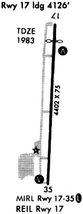
| Runway 17/35 | 5399 ft x 75 ft (1646 m x 23 m) | |
| Runway Length Source: | 3RD PARTY SURVEY as of 05/11/2007 | |
| Surface: | Concrete - Good condition - No special surface treatment | |
| Runway Edge Lights: | Medium Intensity | |
Runway Weight Bearing Capacity (in thousands of pounds) |
||
| Single Wheel Landing Gear: | 30.0 | |
Runway 17 |
Runway 35 |
|
Elevation: |
2012.8 | 1974.4 |
Latitude: |
35-26-17.5462N | 35-25-24.1475N |
Longitude: |
099-23-39.3234W | 099-23-39.4714W |
|
Runway True Alignment: |
180 | 000 |
Glide Path Angle: |
3.0 degrees | 3.5 degrees |
Traffic Pattern: |
Left | Left |
Runway Markings Type: |
Nonprecision Instrument | Nonprecision Instrument |
Runway Markings Condition: |
Good | Good |
Object at End: |
POLE | |
Object Height: |
26 | |
Distance from End: |
990 | |
Object Centerline Offset: |
270 ft. left of centerline | |
Visual Glide Slope Indicators: |
2-Light PAPI On Left Side Of Runway | 2-Light PAPI On Left Side Of Runway |
Approach Light System: |
Omnidirectional Approach Lighting System | |
REIL: |
No | Yes |
Threshold Crossing Height: |
42 | 39 |
Services
Airframe Repair: |
None |
Powerplant Repair: |
None |
Bottled Oxygen: |
None |
Bulk Oxygen: |
None |
Fuel Available: |
100LL |
Landing Fees: |
No |
Parking: |
Tiedowns available |
Maps & Diagrams
ELK Sectional
Flight Planning
at skyvector.com
at skyvector.com