Location
Latitude: |
39-25-38.8510N (39.427459) |
Longitude: |
101-02-47.8310W (-101.04662) |
Elevation: |
3188.2 feet MSL (972 m MSL) |
Magnetic Variation: |
5.4 E (as of April 2024 from WMM2020 model) |
Time Zone: |
UTC -6.0 (Standard Time) UTC -5.0 (Daylight Savings Time) |
From City: |
02 N.M. N of Colby, Kansas |
Found On: |
Wichita Chart |
FAA Region: |
ACE |
Contacts
Manager: |
Publicly owned: |
| MARK OSTMEYER 5 ARPT PLAZZA COLBY, KS 67701 785-460-4438 |
CITY OF COLBY 585 N. FRANKLIN COLBY, KS 67701 785-460-4438 |
Operations
Airport Status: |
Operational |
Facility Use: |
Public |
Type: |
Airport |
Activation Date: |
12/1944 |
Control tower: |
No |
Attendance (Months/Days/Hours): |
Months/Days/Hours ALL/SUN/1000-1700 |
Boundary ARTCC: |
ZDV (Denver) |
Responsible ARTCC: |
ZDV (Denver) |
Lighting Schedule: |
SEE RMK |
Segmented Circle Indicator: |
No |
Traffic Pattern Altitude (MSL): |
4188 feet (1277 m) |
NOTAMs Facility: |
ICT |
NOTAM-D Service: |
Yes |
International Airport of Entry: |
No |
Customs Landing Rights: |
No |
Military Landing Rights: |
Yes |
Civil/Military Joint Use: |
No |
Based Aircraft
| Single Engine: | 21 |
Annual Operations (as of 09/18/2022)
| Total Operations: | 5550 | |
| GA Local: | 3500 | 63.1% |
| GA Itinerant: | 2000 | 36.0% |
| Military Aircraft: | 50 | 0.9% |
Communications
| CTAF: | 122.800 |
| Unicom: | 122.800 |
| AWOS-3P: | 118.175 (785-460-4499) |
- APCH/DEP CTL SVC PRVDD BY DENVER ARTCC (ZDV) ON FREQS 132.7/226.675 (GOODLAND RCAG).
Fixed Based Operators (FBOs) & Fuel
(Click on a business for detail)
Please help us keep this information up to date. This is a FREE SERVICE just like everything else on Airport Guide! If you see that a business needs to be added, modified, or deleted please fill out our Update Form.
To add, modify, or delete a business click here.
Please help us keep this information up to date. This is a FREE SERVICE just like everything else on Airport Guide! If you see that a business needs to be added, modified, or deleted please fill out our Update Form.
Area Code: 785 |
| Business Name | Frequency | Phone | Fuel Grade |
|---|---|---|---|
| Roesch Aviatio, Inc.
Update FBO info |
Unicom 122.8 | 462-2647 | 100LL, Jet A |
Flight Service Stations
| Primary | Alternate | |
| FSS on Field: | N | |
| FSS Name (ID): | Wichita(ICT) | |
| Frequency: | ||
| Toll Free Phone: | 1-800-WX-BRIEF |
Instrument Procedures / Charts
FAA Terminal Procedures valid from 0901Z 03/21/24 to 0901Z 04/18/24.
There are various types of charts available for an airport. They are listed in the Page Type column. Here is a legend for those types:
APD - Airport Diagram
DP - Departure Procedure Charts
HOT - Hot Spots
IAP - Instrument Approach Procedure Charts
MIN - Minimums
STAR - Standard Terminal Arrival Charts
| Page Type | Page Name | Volume | Action Since Last Cycle |
|---|---|---|---|
| IAP | RNAV (GPS) RWY 17 | NC-2 | |
| IAP | RNAV (GPS) RWY 35 | NC-2 | |
| MIN | ALTERNATE MINIMUMS | NC-2 | |
| MIN | TAKEOFF MINIMUMS | NC-2 |
Terminal Procedures are only available for airports in several countries with more being added all the time. If you are looking for a specific country's charts, please send an email to support(at)airportguide.com stating the country name. This will be used to prioritize the implementation.
Navigation Aids (Navaids) near CBK
| Dist (NM) | ID | Morse Code | Name | Type | Freq | True Hdg | Mag Hdg |
|---|---|---|---|---|---|---|---|
| 4.9 | JDM | . _ _ _ _ . . _ _ | Wheatfield | NDB | 408 | 359 | 354 |
| 21.7 | OEL | _ _ _ . . _ . . | Oakley | NDB | 380 | 150 | 145 |
| 26.9 | GL | _ _ . . _ . . | Shugr | NDB | 414 | 252 | 246 |
| 30.0 | GLD | _ _ . . _ . . _ . . | Goodland | VORTAC | 115.10 | 265 | 259 |
| 33.7 | OIN | _ _ _ . . _ . | Oberlin | NDB | 341 | 44 | 39 |
| 37.9 | SYF | . . . _ . _ _ . . _ . | St Francis | NDB | 386 | 298 | 292 |
| 39.4 | HLC | . . . . . _ . . _ . _ . | Hill City | VORTAC | 113.70 | 104 | 99 |
| 50.7 | MCK | _ _ _ . _ . _ . _ | Mc Cook | FAN MARKER | 26 | 21 | |
| 51.0 | MCK | _ _ _ . _ . _ . _ | Mc Cook | VOR-DME | 115.30 | 23 | 18 |
| 57.3 | TQK | _ _ _ . _ _ . _ | Scott City | NDB | 256 | 172 | 167 |
| 58.4 | ITR | . . _ . _ . | Kit Carson | NDB | 209 | 259 | 253 |
| 59.3 | NRN | _ . . _ . _ . | Norton | NDB | 230 | 63 | 58 |
| 61.9 | HCT | . . . . _ . _ . _ | Hayes Center | VORTAC | 117.70 | 5 | 360 |
| 66.7 | CSB | _ . _ . . . . _ . . . | Harry Strunk | NDB | 389 | 37 | 32 |
| 83.0 | PHG | . _ _ . . . . . _ _ . | Phillipsburg | NDB | 368 | 77 | 72 |
| 89.4 | HYS | . . . . _ . _ _ . . . | Hays | VORTAC | 110.40 | 112 | 107 |
| 91.8 | GCK | _ _ . _ . _ . _ . _ | Garden City | VORTAC | 113.30 | 170 | 165 |
| 92.1 | GGF | _ _ . _ _ . . . _ . | Grant | NDB | 359 | 340 | 334 |
| 92.5 | HY | . . . . _ . _ _ | Nette | NDB | 374 | 114 | 109 |
| 97.1 | GC | _ _ . _ . _ . | Pieve | NDB | 347 | 170 | 165 |
Nearby Airports with Fuel
Notices to Airmen (NOTAMS)
Remarks
| A110-1 | SEASONAL AG OPERATIONS |
| A110-2 | FOR CD CTC DENVER ARTCC AT 303-651-4257. |
| A17 | FOR SVC CALL (785) 460-4438/460-3298. |
| A42-17 | RY 17/35 MARKINGS SLIGHTLY FADED. |
| A81-APT | ACTVT REIL RWY 17 & 35; PAPI RWY 17 & 35; MIRL RWY 17/35; TWY LGTS - CTAF. |
| A96 | ULTRALIGHT ACTIVITY ON & INVOF ARPT. |
Runways
Runway Summary
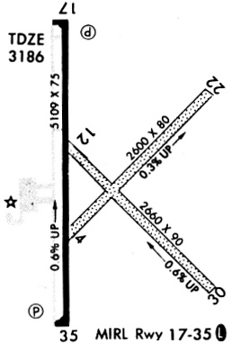
| Runways: | 04/22 12/30 17/35 |
| Longest Runway: | 17/35 is 5110 ft (1558 m) long |
| Runways with an Instrument Approach: |
CBK Airport Runway Details
| Runway 04/22 | 2600 ft x 80 ft (792 m x 24 m) | |
| Runway Length Source: | 3RD PARTY SURVEY as of 09/26/2020 | |
| Surface: | Turf - Good condition - No special surface treatment | |
Runway 04 |
Runway 22 |
|
Elevation: |
3162.3 | 3170.7 |
Latitude: |
39-25-30.6615N | 39-25-48.6585N |
Longitude: |
101-02-53.6852W | 101-02-30.0440W |
|
Runway True Alignment: |
046 | 226 |
Glide Path Angle: |
0.0 degrees | 0.0 degrees |
Traffic Pattern: |
Left | Left |
| Runway 12/30 | 2660 ft x 90 ft (811 m x 27 m) | |
| Runway Length Source: | 3RD PARTY SURVEY as of 09/26/2020 | |
| Surface: | Turf - Good condition - No special surface treatment | |
Runway 12 |
Runway 30 |
|
Elevation: |
3170.2 | 3152.8 |
Latitude: |
39-25-41.9584N | 39-25-23.2496N |
Longitude: |
101-02-53.5857W | 101-02-29.7720W |
|
Runway True Alignment: |
135 | 315 |
Glide Path Angle: |
0.0 degrees | 0.0 degrees |
Traffic Pattern: |
Left | Left |
| Runway 17/35 | 5110 ft x 75 ft (1558 m x 23 m) | |
| Runway Length Source: | 3RD PARTY SURVEY as of 09/26/2020 | |
| Surface: | Turf - Good condition - Aggregate friction seal coat | |
| Runway Edge Lights: | Medium Intensity | |
Runway Weight Bearing Capacity (in thousands of pounds) |
||
| Single Wheel Landing Gear: | 30.0 | |
| Dual Wheel Landing Gear: | 38.0 | |
Runway 17 |
Runway 35 |
|
Elevation: |
3188.2 | 3155.1 |
Latitude: |
39-26-06.9406N | 39-25-16.4425N |
Longitude: |
101-02-53.8468W | 101-02-54.2901W |
|
Runway True Alignment: |
180 | 000 |
Glide Path Angle: |
3.0 degrees | 3.0 degrees |
Traffic Pattern: |
Left | Left |
Runway Markings Type: |
Nonprecision Instrument | Nonprecision Instrument |
Runway Markings Condition: |
Fair | Fair |
Object at End: |
TREE | |
Object Height: |
60 | |
Distance from End: |
1181 | |
Visual Glide Slope Indicators: |
4-Light PAPI On Left Side Of Runway | 4-Light PAPI On Left Side Of Runway |
REIL: |
Yes | Yes |
Threshold Crossing Height: |
40 | 48 |
Services
Airframe Repair: |
None |
Powerplant Repair: |
None |
Bottled Oxygen: |
None |
Bulk Oxygen: |
None |
Fuel Available: |
100LL |
Landing Fees: |
No |
Parking: |
Tiedowns available |
Maps & Diagrams
CBK Sectional
Flight Planning
at skyvector.com
at skyvector.com