Location
Latitude: |
33-37-09.0000N (33.619167) |
Longitude: |
114-43-00.8000W (-114.716889) |
Elevation: |
399.6 feet MSL (122 m MSL) |
Magnetic Variation: |
10.6 E (as of April 2024 from WMM2020 model) |
Time Zone: |
UTC -8.0 (Standard Time) UTC -7.0 (Daylight Savings Time) |
From City: |
06 N.M. W of Blythe, California |
Found On: |
Phoenix Chart |
FAA Region: |
AWP |
Contacts
Manager: |
Publicly owned: |
| ANGELA JAMISON 4080 LEMON STREET, 14TH FLOOR RIVERSIDE, CA 92501 951-955-9418 |
COUNTY OF RIVERSIDE 4080 LEMON STREET, 14TH FLOOR RIVERSIDE, CA 90501 951-955-9418 |
Operations
Airport Status: |
Operational |
Facility Use: |
Public |
Type: |
Airport |
Activation Date: |
04/1940 |
Control tower: |
No |
Attendance (Months/Days/Hours): |
Months/Days/Hours APR-OCT/ALL/0700-1600 |
Boundary ARTCC: |
ZLA (Los Angeles) |
Responsible ARTCC: |
ZLA (Los Angeles) |
Lighting Schedule: |
SEE RMK |
Segmented Circle Indicator: |
Yes |
Traffic Pattern Altitude (MSL): |
1400 feet (427 m) |
NOTAMs Facility: |
BLH |
NOTAM-D Service: |
Yes |
International Airport of Entry: |
No |
Customs Landing Rights: |
No |
Military Landing Rights: |
Yes |
Civil/Military Joint Use: |
No |
Based Aircraft
| Single Engine: | 1 |
| Multi Engine: | 1 |
Annual Operations (as of 12/31/2020)
| Total Operations: | 13595 | |
| GA Local: | 6757 | 49.7% |
| GA Itinerant: | 6757 | 49.7% |
| Military Aircraft: | 81 | 0.6% |
Communications
| CTAF: | 122.800 |
| Unicom: | 122.800 |
| ASOS: | 120.175 (760-922-3000) |
- APCH/DEP CTL SVC PRVDD BY LOS ANGELES ARTCC (ZLA) ON FREQS 128.15/285.6 (LAGUNA RCAG).
Fixed Based Operators (FBOs) & Fuel
(Click on a business for detail)
Please help us keep this information up to date. This is a FREE SERVICE just like everything else on Airport Guide! If you see that a business needs to be added, modified, or deleted please fill out our Update Form.
To add, modify, or delete a business click here.
Please help us keep this information up to date. This is a FREE SERVICE just like everything else on Airport Guide! If you see that a business needs to be added, modified, or deleted please fill out our Update Form.
Area Code: 760 |
| Business Name | Frequency | Phone | Fuel Grade |
|---|---|---|---|
| Wolfe Enterprises
Update FBO info |
Unicom 122.8 | 922-6125 | 100LL, Jet A |
Flight Service Stations
| Primary | Alternate | |
| FSS on Field: | ||
| FSS Name (ID): | Riverside(RAL) | |
| Frequency: | ||
| Toll Free Phone: | 1-800-WX-BRIEF |
Instrument Procedures / Charts
FAA Terminal Procedures valid from 0901Z 03/21/24 to 0901Z 04/18/24.
There are various types of charts available for an airport. They are listed in the Page Type column. Here is a legend for those types:
APD - Airport Diagram
DP - Departure Procedure Charts
HOT - Hot Spots
IAP - Instrument Approach Procedure Charts
MIN - Minimums
STAR - Standard Terminal Arrival Charts
| Page Type | Page Name | Volume | Action Since Last Cycle |
|---|---|---|---|
| IAP | RNAV (GPS) RWY 26 | SW-3 | Changed |
| IAP | VOR/DME RWY 26 | SW-3 | Changed |
| IAP | VOR/DME-A | SW-3 | Changed |
| MIN | ALTERNATE MINIMUMS | SW-3 | |
| MIN | TAKEOFF MINIMUMS | SW-3 |
Terminal Procedures are only available for airports in several countries with more being added all the time. If you are looking for a specific country's charts, please send an email to support(at)airportguide.com stating the country name. This will be used to prioritize the implementation.
Navigation Aids (Navaids) near BLH
| Dist (NM) | ID | Morse Code | Name | Type | Freq | True Hdg | Mag Hdg |
|---|---|---|---|---|---|---|---|
| 2.6 | BLH | _ . . . . _ . . . . . . | Blythe | VORTAC | 117.40 | 238 | 227 |
| 29.0 | PKE | . _ _ . _ . _ . | Parker | VORTAC | 117.90 | 3 | 352 |
| 51.4 | BZA | _ . . . _ _ . . . _ | Bard | VORTAC | 116.80 | 173 | 163 |
| 58.6 | NYL | _ . _ . _ _ . _ . . | Yuma | TACAN | 113.70 | 174 | 164 |
| 60.2 | TNP | _ _ . . _ _ . | Twentynine Palms | VORTAC | 114.20 | 299 | 288 |
| 64.8 | MXL | Mexicali | VOR-DME | 115.00 | 203 | 192 | |
| 65.6 | IPL | . . . _ _ . . _ . . | Imperial | VORTAC | 115.90 | 217 | 206 |
| 67.6 | NJK | _ . . _ _ _ _ . _ | El Centro | TACAN | 111.00 | 225 | 214 |
| 69.9 | EED | . . _ . . | Needles | VORTAC | 115.20 | 9 | 358 |
| 72.1 | TRM | _ . _ . _ _ | Thermal | VORTAC | 116.20 | 270 | 259 |
| 82.4 | NXP | _ . _ . . _ . _ _ . | Coyote | TACAN | 133.60 | 299 | 288 |
| 86.8 | PSP | . _ _ . . . . . _ _ . | Palm Springs | VORTAC | 115.50 | 280 | 269 |
| 93.5 | GFS | _ _ . . . _ . . . . | Goffs | VORTAC | 114.40 | 346 | 335 |
| 95.2 | BXK | _ . . . _ . . _ _ . _ | Buckeye | VORTAC | 110.60 | 95 | 85 |
| 97.9 | JLI | . _ _ _ . _ . . . . | Julian | VORTAC | 114.00 | 253 | 242 |
Nearby Airports with Fuel
Notices to Airmen (NOTAMS)
Remarks
| A110*G | THIS AIRPORT HAS BEEN SURVEYED BY THE NATIONAL GEODETIC SURVEY. |
| A110-1 | ACFT OVER 12500 LBS AVOID HOUSING AREA 1.5 NM SW BLO 2000' FINAL APCH RWY 35 BE ESTABD 2 NM FM TOUCHDOWN. |
| A110-2 | DEP FM RY 17 MAKE CLIMBING LEFT TURN SOON AS SAFETY PERMITS. USE WIDE TFC PATTERN FOR RYS 26 & 35. |
| A110-3 | POWER PLANT 1 MILE EAST OF ARPT PRODUCING THERMAL PLUMES; AVOID LOW ALTITUDE DIRECT OVERFLIGHT OF THE POWER PLANT. |
| A110-4 | PAJA. PRCHT TRNG HIGH AND LOW LVLS ALL HRS NE QUAD OF ARPT |
| A110-5 | FOR CD IF UNA TO CTC ON FSS FREQ, CTC LOS ANGELES ARTCC AT 661-575-2079. |
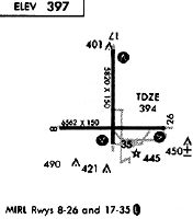
| A81-APT | ACTVT VASI RWY 17, 35 & 26; MIRL RWY 17/35 & 08/26 - CTAF |
Runways
Runway Summary
| Runways: | 08/26 17/35 |
| Longest Runway: | 08/26 is 6543 ft (1994 m) long |
| Runways with an Instrument Approach: |
BLH Airport Runway Details
| Runway 08/26 | 6543 ft x 150 ft (1994 m x 46 m) | |
| Runway Length Source: | NGS as of 02/23/2006 | |
| Surface: | Asphalt - Fair condition - No special surface treatment | |
| Runway Edge Lights: | Medium Intensity | |
Runway Weight Bearing Capacity (in thousands of pounds) |
||
| Single Wheel Landing Gear: | 80.0 | |
| Dual Wheel Landing Gear: | 115.0 | |
| Dual Tandem Wheel Landing Gear: | 210.0 | |
Runway 08 |
Runway 26 |
|
Elevation: |
397.1 | 395.7 |
Latitude: |
33-36-59.7683N | 33-36-59.5333N |
Longitude: |
114-43-39.8259W | 114-42-22.4640W |
|
Runway True Alignment: |
090 | 270 |
Glide Path Angle: |
0.0 degrees | 3.0 degrees |
Traffic Pattern: |
Left | Left |
Runway Markings Type: |
Basic | Nonprecision Instrument |
Runway Markings Condition: |
Good | Good |
Visual Glide Slope Indicators: |
4-Box VASI On Left Side Of Runway | |
REIL: |
No | No |
Touchdown Lights: |
No | No |
Centerline Lights: |
No | No |
Threshold Crossing Height: |
42 |
| Runway 17/35 | 5800 ft x 100 ft (1768 m x 30 m) | |
| Runway Length Source: | NGS as of 02/23/2006 | |
| Surface: | Asphalt - Fair condition - No special surface treatment | |
| Runway Edge Lights: | Medium Intensity | |
Runway Weight Bearing Capacity (in thousands of pounds) |
||
| Single Wheel Landing Gear: | 52.0 | |
| Dual Wheel Landing Gear: | 76.0 | |
| Dual Tandem Wheel Landing Gear: | 135.0 | |
Runway 17 |
Runway 35 |
|
Elevation: |
399.2 | 394.3 |
Latitude: |
33-37-48.1258N | 33-36-50.7511N |
Longitude: |
114-43-00.2703W | 114-43-00.5427W |
|
Runway True Alignment: |
180 | 000 |
Glide Path Angle: |
3.0 degrees | 3.0 degrees |
Traffic Pattern: |
Left | Left |
Runway Markings Type: |
Basic | Basic |
Runway Markings Condition: |
Fair | Fair |
Visual Glide Slope Indicators: |
4-Box VASI On Left Side Of Runway | 4-Box VASI On Left Side Of Runway |
REIL: |
No | No |
Touchdown Lights: |
No | No |
Centerline Lights: |
No | No |
Threshold Crossing Height: |
40 | 40 |
Services
Airframe Repair: |
Minor |
Powerplant Repair: |
Minor |
Fuel Available: |
100LL, Jet A-1+ |
Landing Fees: |
No |
Parking: |
Tiedowns available |
Maps & Diagrams
BLH Sectional
Flight Planning
at skyvector.com
at skyvector.com