
Location
Latitude: |
60-17-36.2393N (60.2934) |
Longitude: |
005-13-05.3045E (5.21814) |
Elevation: |
170 feet MSL (52 m MSL) |
Magnetic Variation: |
2.4 E (as of April 2024 from WMM2020 model) |
Time Zone: |
UTC +1.0 (Standard Time) UTC +2.0 (Daylight Savings Time) |
Contacts
Manager: |
: |
Operations
Airport Status: |
Operational |
Facility Use: |
Public |
Type: |
Airport |
Traffic Pattern Altitude (MSL): |
1170 feet (357 m) |
Based Aircraft
Annual Operations (as of )
Communications
| TWR: | 119.1 |
| GND: | 121.9 |
| RADAR: | 121 |
| ATIS: | 125.25 |
| ARR: | 125 |
| DIRECTOR: | 118.85 |
Fixed Based Operators (FBOs) & Fuel
(Click on a business for detail)
Please help us keep this information up to date. This is a FREE SERVICE just like everything else on Airport Guide! If you see that a business needs to be added, modified, or deleted please fill out our Update Form.
To add, modify, or delete a business click here.
Please help us keep this information up to date. This is a FREE SERVICE just like everything else on Airport Guide! If you see that a business needs to be added, modified, or deleted please fill out our Update Form.
| Business Name | Frequency | Phone | Fuel Grade |
|---|
Flight Service Stations
| Primary | Alternate | |
| FSS on Field: | ||
| FSS Name (ID): | ||
| Frequency: | ||
| Toll Free Phone: |
Instrument Procedures / Charts
Terminal Procedures are only available for airports in several countries with more being added all the time. If you are looking for a specific country's charts, please send an email to support(at)airportguide.com stating the country name. This will be used to prioritize the implementation.
Navigation Aids (Navaids) near BGO
| Dist (NM) | ID | Morse Code | Name | Type | Freq | True Hdg | Mag Hdg |
|---|---|---|---|---|---|---|---|
| 0.4 | FLE | Flesland | TACAN | 114.50 | 341 | 339 | |
| 1.1 | FLS | Flesland | VOR-DME | 115.55 | 350 | 348 | |
| 7.8 | ASK | Askoy | NDB | 360 | 351 | 349 | |
| 14.9 | BTA | Bratta | NDB | 336 | 170 | 168 | |
| 15.6 | VOO | Vollo | VOR-DME | 114.85 | 350 | 348 | |
| 30.6 | STD | Stord | VOR-DME | 113.40 | 172 | 170 | |
| 49.0 | TRL | Troll | DME | 116.10 | 296 | 294 | |
| 56.8 | KRM | Karmoy | VOR-DME | 115.15 | 180 | 178 | |
| 61.0 | VG | Vaga | NDB | 275 | 175 | 173 | |
| 64.3 | FT | Fleten | NDB | 345 | 8 | 6 | |
| 67.3 | VNG | Vangnes | NDB | 404 | 37 | 34 | |
| 67.7 | BL | Bringeland | NDB | 374 | 13 | 11 | |
| 69.9 | LS | Langeneset | NDB | 339 | 15 | 13 | |
| 70.8 | RSY | Rennesoy | NDB | 378 | 169 | 167 | |
| 76.7 | SOG | Sogndal | VOR-DME | 114.20 | 47 | 44 | |
| 76.9 | REK | Reksten | NDB | 379 | 352 | 350 | |
| 77.5 | FLO | Floro | VOR-DME | 112.30 | 355 | 353 | |
| 81.2 | ZO | Sola | NDB | 352 | 170 | 168 | |
| 86.0 | SOA | Sola | TACAN | 112.25 | 171 | 169 | |
| 86.1 | ZOL | Sola | VOR-DME | 116.85 | 171 | 169 |
Nearby Airports with Fuel
| Dist (NM) | Name (Airport IDs) | True Hdg | Mag Hdg | Fuel Grade |
|---|
Notices to Airmen (NOTAMS)
Remarks
No remarks for this landing facility
Runways
Runway Summary
| Runways: | 17/35 |
| Longest Runway: | 17/35 is 9810 ft (2990 m) long |
| Runways with an Instrument Approach: |
BGO Airport Runway Details
| Runway 17/35 | 9810 ft x 148 ft (2990 m x 45 m) | |
| Runway Edge Lights: | Yes Intensity | |
Runway 17 |
Runway 35 |
|
Elevation: |
165 | 146 |
Latitude: |
60.30659866333 | 60.28010177612 |
Longitude: |
5.2136998176574 | 5.2225799560546 |
|
Runway True Alignment: |
170.5 | 350.5 |
Glide Path Angle: |
0.0 degrees | 0.0 degrees |
REIL: |
Yes | Yes |
Threshold Elevation: |
165 | 146 |
Displaced Threshold: |
886 | 889 |
Services
Maps & Diagrams
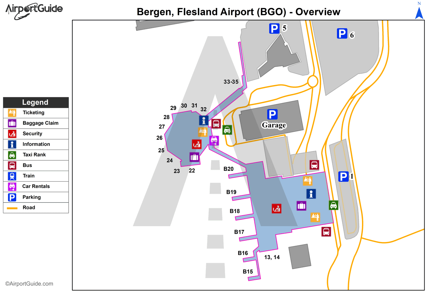
BGO Sectional
Flight Planning
at skyvector.com
at skyvector.com
