Location
Latitude: |
40-29-36.7730N (40.493548) |
Longitude: |
084-17-53.0680W (-84.298074) |
Elevation: |
912.3 feet MSL (278 m MSL) |
Magnetic Variation: |
6.4 W (as of April 2024 from WMM2020 model) |
Time Zone: |
UTC -5.0 (Standard Time) UTC -4.0 (Daylight Savings Time) |
From City: |
08 N.M. SW of Wapakoneta, Ohio |
Found On: |
Detroit Chart |
FAA Region: |
AGL |
Contacts
Manager: |
Publicly owned: |
| TED BERGSTROM PO BOX 400 NEW KNOXVILLE, OH 45871-0400 419-753-2810 |
AUGLAIZE CO ARPT AUTH PO BOX 400 NEW KNOXVILLE, OH 45871-0400 419-753-2810 |
Operations
Airport Status: |
Operational |
Facility Use: |
Public |
Type: |
Airport |
Activation Date: |
05/1956 |
Control tower: |
No |
Attendance (Months/Days/Hours): |
Months/Days/Hours ALL/MON-FRI/0700-1700 |
Boundary ARTCC: |
ZID (Indianapolis) |
Responsible ARTCC: |
ZID (Indianapolis) |
Lighting Schedule: |
SEE RMK |
Segmented Circle Indicator: |
No |
Traffic Pattern Altitude (MSL): |
1912 feet (583 m) |
NOTAMs Facility: |
DAY |
NOTAM-D Service: |
Yes |
International Airport of Entry: |
No |
Customs Landing Rights: |
No |
Military Landing Rights: |
No |
Civil/Military Joint Use: |
No |
Based Aircraft
| Single Engine: | 26 |
| Multi Engine: | 2 |
| Jet Engine: | 5 |
Annual Operations (as of 09/14/2021)
| Total Operations: | 12306 | |
| Air Taxi: | 1800 | 14.6% |
| GA Local: | 7000 | 56.9% |
| GA Itinerant: | 3500 | 28.4% |
| Military Aircraft: | 6 | 0.0% |
Communications
| CTAF: | 122.800 |
| Unicom: | 122.800 |
| Approach: | COLUMBUS 118.425 118.425 118.425 118.425 |
| Departure: | COLUMBUS 118.425 118.425 118.425 118.425 |
| AWOS-3PT: | 128.325 (419-753-2821) |
Fixed Based Operators (FBOs) & Fuel
(Click on a business for detail)
Please help us keep this information up to date. This is a FREE SERVICE just like everything else on Airport Guide! If you see that a business needs to be added, modified, or deleted please fill out our Update Form.
To add, modify, or delete a business click here.
Please help us keep this information up to date. This is a FREE SERVICE just like everything else on Airport Guide! If you see that a business needs to be added, modified, or deleted please fill out our Update Form.
Area Code: 419 |
| Business Name | Frequency | Phone | Fuel Grade |
|---|---|---|---|
| Neil Armstrong Airport
Update FBO info |
Unicom 122.8 | 753-2810 | 100LL, Jet A |
| Tri-Con Aviation, Inc.
Update FBO info |
753-2895 |
Flight Service Stations
| Primary | Alternate | |
| FSS on Field: | N | |
| FSS Name (ID): | Dayton(DAY) | |
| Frequency: | ||
| Toll Free Phone: | 1-800-WX-BRIEF |
Instrument Procedures / Charts
FAA Terminal Procedures valid from 0901Z 03/21/24 to 0901Z 04/18/24.
There are various types of charts available for an airport. They are listed in the Page Type column. Here is a legend for those types:
APD - Airport Diagram
DP - Departure Procedure Charts
HOT - Hot Spots
IAP - Instrument Approach Procedure Charts
MIN - Minimums
STAR - Standard Terminal Arrival Charts
| Page Type | Page Name | Volume | Action Since Last Cycle |
|---|---|---|---|
| IAP | RNAV (GPS) RWY 08 | EC-2 | |
| IAP | RNAV (GPS) RWY 26 | EC-2 | |
| IAP | VOR-A | EC-2 | |
| MIN | TAKEOFF MINIMUMS | EC-2 |
Terminal Procedures are only available for airports in several countries with more being added all the time. If you are looking for a specific country's charts, please send an email to support(at)airportguide.com stating the country name. This will be used to prioritize the implementation.
Navigation Aids (Navaids) near AXV
| Dist (NM) | ID | Morse Code | Name | Type | Freq | True Hdg | Mag Hdg |
|---|---|---|---|---|---|---|---|
| 12.2 | CQA | _ . _ . _ _ . _ . _ | Lakefield | NDB | 205 | 266 | 272 |
| 17.0 | ROD | . _ . _ _ _ _ . . | Rosewood | VORTAC | 117.50 | 136 | 142 |
| 19.7 | AOH | . _ _ _ _ . . . . | Allen County | VOR | 108.40 | 49 | 56 |
| 26.4 | VFU | . . . _ . . _ . . . _ | Stanley | NDB | 411 | 327 | 333 |
| 28.8 | RUV | . _ . . . _ . . . _ | Rushsylvania | NDB | 326 | 93 | 100 |
| 29.0 | DQN | _ . . _ _ . _ _ . | Dayton | VOR-DME | 114.50 | 189 | 195 |
| 35.9 | DAY | _ . . . _ _ . _ _ | Dayton J M Cox-Day | VOT | 111.00 | 173 | 179 |
| 37.1 | FBC | . . _ . _ . . . _ . _ . | Flag City | VORTAC | 108.20 | 41 | 48 |
| 38.8 | AT | . _ _ | Bruny | NDB | 315 | 182 | 188 |
| 42.0 | FFO | . . _ . . . _ . _ _ _ | Patterson | TACAN | 109.20 | 164 | 170 |
| 42.7 | BNR | _ . . . _ . . _ . | Benton Ridge | NDB | 334 | 41 | 48 |
| 44.1 | CCJ | _ . _ . _ . _ . . _ _ _ | Clark County | NDB | 341 | 147 | 154 |
| 44.6 | SGH | . . . _ _ . . . . . | Springfield | DME | 113.2 | 152 | 159 |
| 44.6 | XSF | _ . . _ . . . . . _ . | Springfield | TACAN | 133.80 | 151 | 158 |
| 49.9 | FWA | . . _ . . _ _ . _ | Fort Wayne | VORTAC | 117.80 | 306 | 312 |
| 49.9 | FWA | . . _ . . _ _ . _ | Fort Wayne Baer | VOT | 111.00 | 305 | 311 |
| 50.4 | JN | . _ _ _ _ . | Balll | NDB | 365 | 248 | 254 |
| 50.8 | RID | . _ . . . _ . . | Richmond | DME | 110.6 | 209 | 215 |
| 52.4 | MIE | _ _ . . . | Muncie | VOR-DME | 114.40 | 253 | 259 |
| 54.9 | MW | _ _ . _ _ | Onida | NDB | 223 | 181 | 187 |
Nearby Airports with Fuel
Notices to Airmen (NOTAMS)
Remarks
| A110-1 | FOR CD CTC COLUMBUS APCH AT 614-338-8537. |
| A110-2 | WILDLIFE ON & INVOF ARPT. |
| A17 | FOR SVC & FUEL CALL AMGR. |
| A57-08 | APCH SLP 13:1 TO DTHR DUE TO +89 FT TREE, 1179 FT DIST, 248 FT L. |
| A57-26 | APCH SLP 37:1 TO DTHR DUE TO +15 FT ROAD, 567 FT DIST, 275 FT R. |
| A58-08 | 3 FT CROPS, 0-70 FT DIST, 200 FT R. |
| A58-26 | 8 FT TRRN, 0-40 FT DIST, 190 FT L; 8 FT FENCE, 65-200 FT DIST, 220-230 FT L. |
| A70-FUEL-10 | 0LL 100LL & JET A1+ AVBL H24 SELF SVC VIA CREDIT CARD. |
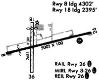
| A81-APT | ACTVT REIL RWY 08 & 26; MIRL RWY 08/26 - 122.7. |
Runways
Runway Summary
| Runways: | 08/26 |
| Longest Runway: | 08/26 is 5500 ft (1676 m) long |
| Runways with an Instrument Approach: | 26 |
AXV Airport Runway Details
| Runway 08/26 | 5500 ft x 100 ft (1676 m x 30 m) | |
| Runway Length Source: | 3RD PARTY SURVEY as of 07/28/2022 | |
| Surface: | Asphalt - Good condition - Saw-cut or plastic grooved | |
| Runway Edge Lights: | Medium Intensity | |
Runway 08 |
Runway 26 |
|
Elevation: |
907.7 | 908.0 |
Latitude: |
40-29-30.4664N | 40-29-43.0772N |
Longitude: |
084-18-27.6860W | 084-17-18.4488W |
|
Runway True Alignment: |
077 | 257 |
ILS Type: |
LOC/DME | |
Glide Path Angle: |
4.0 degrees | 3.0 degrees |
Traffic Pattern: |
Left | Left |
Runway Markings Type: |
Nonprecision Instrument | Nonprecision Instrument |
Runway Markings Condition: |
Good | Good |
Object at End: |
TREES | ROAD |
Object Height: |
89 | 15 |
Distance from End: |
479 | 330 |
Object Centerline Offset: |
248 ft. left of centerline | 275 ft. right of centerline |
Visual Glide Slope Indicators: |
4-Light PAPI On Left Side Of Runway | 4-Light PAPI On Left Side Of Runway |
REIL: |
Yes | Yes |
Touchdown Lights: |
No | No |
Centerline Lights: |
No | No |
Threshold Crossing Height: |
50 | 40 |
Threshold Elevation: |
910.2 | 908.2 |
Displaced Threshold: |
698 | 237 |
Threshold Latitude: |
40-29-32.0717N | 40-29-42.5310N |
Threshold Longitude: |
084-18-18.8939W | 084-17-21.4284W |
Services
Airframe Repair: |
Major |
Powerplant Repair: |
Major |
Bottled Oxygen: |
None |
Bulk Oxygen: |
High Pressure |
Fuel Available: |
100LL, Jet A+ |
Landing Fees: |
No |
Parking: |
Hangars and tiedowns available |
Other Services: |
Flight Test Support |
Maps & Diagrams
AXV Sectional
Flight Planning
at skyvector.com
at skyvector.com