Location
Latitude: |
41-12-55.6000N (41.215444) |
Longitude: |
083-52-15.1300W (-83.870869) |
Elevation: |
706.0 feet MSL (215 m MSL) |
Magnetic Variation: |
6.8 W (as of April 2024 from WMM2020 model) |
Time Zone: |
UTC -5.0 (Standard Time) UTC -4.0 (Daylight Savings Time) |
From City: |
02 N.M. NE of Deshler, Ohio |
Found On: |
Detroit Chart |
FAA Region: |
AGL |
Contacts
Manager: |
Publicly owned: |
| GARY MYERS 1276 COUNTY ROAD D DESHLER, OH 43516-9763 419-278-1353 |
VILLAGE OF DESHLER 1276 COUNTY ROAD D DESHLER, OH 43516-9763 419-278-1353 |
Operations
Airport Status: |
Operational |
Facility Use: |
Public |
Type: |
Airport |
Activation Date: |
10/1961 |
Control tower: |
No |
Attendance (Months/Days/Hours): |
Months/Days/Hours Unattended |
Boundary ARTCC: |
ZOB (Cleveland) |
Responsible ARTCC: |
ZOB (Cleveland) |
Segmented Circle Indicator: |
No |
Traffic Pattern Altitude (MSL): |
1706 feet (520 m) |
NOTAMs Facility: |
CLE |
NOTAM-D Service: |
Yes |
Based Aircraft
| Single Engine: | 6 |
Annual Operations (as of 06/13/2023)
| Total Operations: | 2000 | |
| GA Local: | 1200 | 60.0% |
| GA Itinerant: | 800 | 40.0% |
Communications
| CTAF: | 122.900 |
Fixed Based Operators (FBOs) & Fuel
(Click on a business for detail)
Please help us keep this information up to date. This is a FREE SERVICE just like everything else on Airport Guide! If you see that a business needs to be added, modified, or deleted please fill out our Update Form.
To add, modify, or delete a business click here.
Please help us keep this information up to date. This is a FREE SERVICE just like everything else on Airport Guide! If you see that a business needs to be added, modified, or deleted please fill out our Update Form.
Area Code: 419 |
| Business Name | Frequency | Phone | Fuel Grade |
|---|
Flight Service Stations
| Primary | Alternate | |
| FSS on Field: | N | |
| FSS Name (ID): | Cleveland(CLE) | |
| Frequency: | ||
| Toll Free Phone: | 1-800-WX-BRIEF |
Instrument Procedures / Charts
Terminal Procedures are only available for airports in several countries with more being added all the time. If you are looking for a specific country's charts, please send an email to support(at)airportguide.com stating the country name. This will be used to prioritize the implementation.
Navigation Aids (Navaids) near 6D7
| Dist (NM) | ID | Morse Code | Name | Type | Freq | True Hdg | Mag Hdg |
|---|---|---|---|---|---|---|---|
| 14.8 | BNR | _ . . . _ . . _ . | Benton Ridge | NDB | 334 | 141 | 148 |
| 16.5 | FBC | . . _ . _ . . . _ . _ . | Flag City | VORTAC | 108.20 | 161 | 168 |
| 17.6 | VWV | . . . _ . _ _ . . . _ | Waterville | VOR-DME | 113.10 | 36 | 43 |
| 20.4 | TO | _ _ _ _ | Tophr | NDB | 219 | 353 | 360 |
| 21.4 | FZI | . . _ . _ _ . . . . | Fostoria | NDB | 379 | 94 | 101 |
| 22.9 | TOL | _ _ _ _ . _ . . | Toledo | TACAN | 112.50 | 8 | 15 |
| 26.4 | USE | . . _ . . . . | Fulton | NDB | 375 | 333 | 340 |
| 30.5 | TII | _ . . . . | Tiffin | NDB | 269 | 103 | 110 |
| 30.8 | AOH | . _ _ _ _ . . . . | Allen County | VOR | 108.40 | 188 | 195 |
| 39.8 | VFU | . . . _ . . _ . . . _ | Stanley | NDB | 411 | 238 | 245 |
| 40.4 | ADG | . _ _ . . _ _ . | Adrian | NDB | 278 | 346 | 353 |
| 46.3 | RUV | . _ . . . _ . . . _ | Rushsylvania | NDB | 326 | 168 | 175 |
| 48.7 | PCW | . _ _ . _ . _ . . _ _ | Port Clinton | NDB | 423 | 67 | 74 |
| 48.7 | GW | _ _ . . _ _ | Shenk | NDB | 227 | 276 | 282 |
| 49.1 | TCU | _ _ . _ . . . _ | Tecumseh | NDB | 239 | 359 | 366 |
| 51.3 | BUD | _ . . . . . _ _ . . | Buckeye | VOR | 109.80 | 134 | 141 |
| 53.3 | CRL | _ . _ . . _ . . _ . . | Carleton | VOR-DME | 115.70 | 20 | 27 |
| 54.1 | CQA | _ . _ . _ _ . _ . _ | Lakefield | NDB | 205 | 215 | 222 |
| 56.2 | ROD | . _ . _ _ _ _ . . | Rosewood | VORTAC | 117.50 | 188 | 195 |
| 56.3 | SKY | . . . _ . _ _ . _ _ | Sandusky | VOR-DME | 109.20 | 76 | 83 |
Nearby Airports with Fuel
Notices to Airmen (NOTAMS)
Remarks
| A110-2 | DEER, BIRDS, & WILDLIFE ON & INVOF ARPT. |
| A110-5 | FOR CD CTC TOLEDO APCH AT 419-865-1495. |
| A110-6 | RWY 09 40 FT TREES, 130 FT DIST, ACRS APCH. |
| A14 | GARY.MYERS47@YAHOO.COM. |
| A16 | CELL. |
| A33-09/27 | SOFT WHEN WET. |
| A42-09 | DTHR MKD WITH WHITE CONES. |
| A57-09 | CTLG OBSTN EXCEEDS A 45 DEG SLP. |
| A57-27 | CTLG OBSTN EXCEEDS A 45 DEG SLP. |
| A75 | TIEDOWN ANCHORS & ROPES NOT PRVDD. |
Runways
Runway Summary
| Runways: | 09/27 |
| Longest Runway: | 09/27 is 2480 ft (756 m) long |
| Runways with an Instrument Approach: |
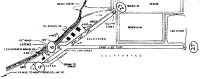
6D7 Airport Runway Details
| Runway 09/27 | 2480 ft x 70 ft (756 m x 21 m) | |
| Surface: | Turf - Excellent condition - No special surface treatment | |
Runway 09 |
Runway 27 |
|
Elevation: |
706.0 | 706.0 |
Latitude: |
41-12-55.3900N | 41-12-55.8100N |
Longitude: |
083-52-31.3500W | 083-51-58.9100W |
Glide Path Angle: |
0.0 degrees | 0.0 degrees |
Traffic Pattern: |
Left | Left |
Object at End: |
TREES | TREES |
Object Height: |
45 | 76 |
Distance from End: |
0 | 0 |
Object Centerline Offset: |
100 ft. left of centerline | 100 ft. right of centerline |
Threshold Elevation: |
706.0 | |
Displaced Threshold: |
725 | |
Threshold Latitude: |
41-12-55.5131N | |
Threshold Longitude: |
083-52-21.8651W |
Services
Airframe Repair: |
Major |
Powerplant Repair: |
Major |
Bottled Oxygen: |
None |
Bulk Oxygen: |
None |
Fuel Available: |
100LL, Jet A+ |
Landing Fees: |
No |
Parking: |
Hangars and tiedowns available |
Maps & Diagrams
6D7 Sectional
Flight Planning
at skyvector.com
at skyvector.com