Location
Latitude: |
43-13-24.4000N (43.223444) |
Longitude: |
122-25-16.2000W (-122.421167) |
Elevation: |
3361.0 feet MSL (1024 m MSL) |
Magnetic Variation: |
14.2 E (as of April 2024 from WMM2020 model) |
Time Zone: |
UTC -8.0 (Standard Time) UTC -7.0 (Daylight Savings Time) |
From City: |
02 N.M. S of Clearwater, Oregon |
Found On: |
Klamath Falls Chart |
FAA Region: |
ANM |
Contacts
Manager: |
Publicly owned: |
| OREGON DEPT OF AVIATION 3040 25TH STREET SE SALEM, OR 97302-1125 503-378-4880 |
US FOREST SERVICE P.O. BOX 1008 ROSEBURG, OR 97470 541-672-6601 |
Operations
Airport Status: |
Operational |
Facility Use: |
Public |
Type: |
Airport |
Control tower: |
No |
Attendance (Months/Days/Hours): |
Months/Days/Hours Unattended |
Boundary ARTCC: |
ZSE (Seattle) |
Responsible ARTCC: |
ZSE (Seattle) |
Segmented Circle Indicator: |
No |
Traffic Pattern Altitude (MSL): |
4361 feet (1329 m) |
NOTAMs Facility: |
MMV |
NOTAM-D Service: |
Yes |
Based Aircraft
Annual Operations (as of 07/26/2017)
| Total Operations: | 400 | |
| GA Itinerant: | 350 | 87.5% |
| Military Aircraft: | 50 | 12.5% |
Communications
| CTAF: | 122.900 |
Fixed Based Operators (FBOs) & Fuel
(Click on a business for detail)
Please help us keep this information up to date. This is a FREE SERVICE just like everything else on Airport Guide! If you see that a business needs to be added, modified, or deleted please fill out our Update Form.
To add, modify, or delete a business click here.
Please help us keep this information up to date. This is a FREE SERVICE just like everything else on Airport Guide! If you see that a business needs to be added, modified, or deleted please fill out our Update Form.
Area Code: 503 |
| Business Name | Frequency | Phone | Fuel Grade |
|---|
Flight Service Stations
| Primary | Alternate | |
| FSS on Field: | N | |
| FSS Name (ID): | Mc Minnville(MMV) | |
| Frequency: | ||
| Toll Free Phone: | 1-800-WX-BRIEF |
Instrument Procedures / Charts
Terminal Procedures are only available for airports in several countries with more being added all the time. If you are looking for a specific country's charts, please send an email to support(at)airportguide.com stating the country name. This will be used to prioritize the implementation.
Navigation Aids (Navaids) near 3S6
| Dist (NM) | ID | Morse Code | Name | Type | Freq | True Hdg | Mag Hdg |
|---|---|---|---|---|---|---|---|
| 40.8 | RBG | . _ . _ . . . _ _ . | Roseburg | VOR-DME | 108.20 | 266 | 252 |
| 41.0 | RBG | . _ . _ . . . _ _ . | Roseburg | NDB | 400 | 271 | 257 |
| 49.6 | OED | _ _ _ . _ . . | Rogue Valley | VORTAC | 113.60 | 206 | 192 |
| 53.8 | MEF | _ _ . . . _ . | Medford | NDB | 356 | 202 | 188 |
| 55.5 | MFR | _ _ . . _ . . _ . | Medford | VOT | 117.20 | 200 | 186 |
| 64.1 | EUG | . . . _ _ _ . | Eugene | VORTAC | 112.90 | 327 | 313 |
| 68.7 | EU | . . . _ | Frakk | NDB | 260 | 329 | 315 |
| 71.1 | LMT | . _ . . _ _ _ | Klamath Falls | VORTAC | 115.90 | 154 | 140 |
| 77.1 | OTH | _ _ _ _ . . . . | North Bend | VOR-DME | 112.10 | 279 | 265 |
| 78.5 | DSD | _ . . . . . _ . . | Deschutes | VORTAC | 117.60 | 37 | 23 |
| 83.1 | OT | _ _ _ _ | Emire | NDB | 378 | 277 | 263 |
| 85.4 | CVO | _ . _ . . . . _ _ _ _ | Corvallis | VOR-DME | 115.40 | 334 | 320 |
| 89.0 | RD | . _ . _ . . | Bodey | NDB | 411 | 42 | 28 |
| 89.8 | MOG | _ _ _ _ _ _ _ . | Montague | NDB | 404 | 181 | 167 |
| 91.1 | LWG | . _ . . . _ _ _ _ . | Lewisburg | NDB | 225 | 336 | 322 |
| 94.9 | LKV | . _ . . _ . _ . . . _ | Lakeview | VORTAC | 112.00 | 116 | 102 |
Nearby Airports with Fuel
Notices to Airmen (NOTAMS)
Remarks
| A110-1 | RY 11/29 HAS +120 FT TREES 250 FT EITHER SIDE OF CNTRLN. |
| A110-4 | ARPT CLSD FROM 01 NOV UNTIL 01 MAY. |
| A110-5 | ELK, DEER AND TURKEY ON AND INVOF ARPT. |
| A110-6 | TREES 4-30' ALONG SOUTH SIDE OF RY WITHIN 50' OF CNTRLN. |
| A110-7 | FOR CD CTC SEATTLE ARTCC AT 253-351-3694. |
| A110-8 | SFC CONDS NOT RPRTD. |
| A32-11/29 | GRADED; 60 FT WIDE; SHOULDERS ROUGH & RUTTED. |
| A42-11 | RY 11/29 THLDS OUTLINED WITH WHITE TIRES. |
| A57-29 | RY 29 22 FT WEATHER INSTRUMENTS AT 10 FT FRM RY END AND 60 FT R OF CNTRLN. |
Runways
Runway Summary
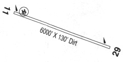
| Runways: | 11/29 |
| Longest Runway: | 11/29 is 5350 ft (1631 m) long |
| Runways with an Instrument Approach: |
3S6 Airport Runway Details
| Runway 11/29 | 5350 ft x 60 ft (1631 m x 18 m) | |
| Surface: | Turf - Good condition - No special surface treatment | |
Runway 11 |
Runway 29 |
|
Elevation: |
3230.0 | 3359.0 |
Latitude: |
43-13-41.3489N | 43-13-07.4575N |
Longitude: |
122-25-43.9215W | 122-24-48.4613W |
|
Runway True Alignment: |
130 | 310 |
Glide Path Angle: |
0.0 degrees | 0.0 degrees |
Traffic Pattern: |
Left | Left |
Runway Markings Type: |
Nonstandard (other than numbers only) | |
Object at End: |
TREES | TREES |
Object Height: |
101 | 91 |
Distance from End: |
789 | 333 |
Object Centerline Offset: |
30 ft. left of centerline | 30 ft. right of centerline |
Services
Airframe Repair: |
None |
Powerplant Repair: |
None |
Bottled Oxygen: |
None |
Fuel Available: |
100LL, Jet A |
Landing Fees: |
No |
Parking: |
Tiedowns available |
Maps & Diagrams
3S6 Sectional
Flight Planning
at skyvector.com
at skyvector.com