Location
Latitude: |
37-59-54.8990N (37.998583) |
Longitude: |
101-44-51.3880W (-101.747608) |
Elevation: |
3326.1 feet MSL (1014 m MSL) |
Magnetic Variation: |
5.8 E (as of April 2024 from WMM2020 model) |
Time Zone: |
UTC -6.0 (Standard Time) UTC -5.0 (Daylight Savings Time) |
From City: |
01 N.M. N of Syracuse, Kansas |
Found On: |
Wichita Chart |
FAA Region: |
ACE |
Contacts
Manager: |
Publicly owned: |
| STEVE PHILLIPS BOX 1136 SYRACUSE, KS 67878 620-384-5468 |
CITY OF SYRACUSE/HAMILTON CO BOX 1136 SYRACUSE, KS 67878 620-384-5629 |
Operations
Airport Status: |
Operational |
Facility Use: |
Public |
Type: |
Airport |
Activation Date: |
04/1940 |
Control tower: |
No |
Attendance (Months/Days/Hours): |
Months/Days/Hours ALL/MON-FRI/0800-1700 |
Boundary ARTCC: |
ZDV (Denver) |
Responsible ARTCC: |
ZDV (Denver) |
Lighting Schedule: |
SEE RMK |
Segmented Circle Indicator: |
No |
Traffic Pattern Altitude (MSL): |
4326 feet (1319 m) |
NOTAMs Facility: |
ICT |
NOTAM-D Service: |
Yes |
International Airport of Entry: |
No |
Customs Landing Rights: |
No |
Military Landing Rights: |
Yes |
Civil/Military Joint Use: |
No |
Based Aircraft
| Single Engine: | 21 |
Annual Operations (as of 06/15/2022)
| Total Operations: | 5000 | |
| GA Local: | 3600 | 72.0% |
| GA Itinerant: | 1400 | 28.0% |
Communications
| CTAF: | 122.800 |
| Unicom: | 122.800 |
| AWOS-3: | 119.975 (620-384-5869) |
- APCH/DEP CTL SVC PRVDD BY DENVER ARTCC (ZDV) ON FREQS 133.4/377.175 (LA JUNTA RCAG).
Fixed Based Operators (FBOs) & Fuel
(Click on a business for detail)
Please help us keep this information up to date. This is a FREE SERVICE just like everything else on Airport Guide! If you see that a business needs to be added, modified, or deleted please fill out our Update Form.
To add, modify, or delete a business click here.
Please help us keep this information up to date. This is a FREE SERVICE just like everything else on Airport Guide! If you see that a business needs to be added, modified, or deleted please fill out our Update Form.
Area Code: 620 |
| Business Name | Frequency | Phone | Fuel Grade |
|---|
Flight Service Stations
| Primary | Alternate | |
| FSS on Field: | N | |
| FSS Name (ID): | Wichita(ICT) | |
| Frequency: | ||
| Toll Free Phone: | 1-800-WX-BRIEF |
Instrument Procedures / Charts
FAA Terminal Procedures valid from 0901Z 03/21/24 to 0901Z 04/18/24.
There are various types of charts available for an airport. They are listed in the Page Type column. Here is a legend for those types:
APD - Airport Diagram
DP - Departure Procedure Charts
HOT - Hot Spots
IAP - Instrument Approach Procedure Charts
MIN - Minimums
STAR - Standard Terminal Arrival Charts
| Page Type | Page Name | Volume | Action Since Last Cycle |
|---|---|---|---|
| IAP | RNAV (GPS) RWY 18 | NC-2 | |
| IAP | RNAV (GPS) RWY 36 | NC-2 | |
| MIN | ALTERNATE MINIMUMS | NC-2 | |
| MIN | TAKEOFF MINIMUMS | NC-2 |
Terminal Procedures are only available for airports in several countries with more being added all the time. If you are looking for a specific country's charts, please send an email to support(at)airportguide.com stating the country name. This will be used to prioritize the implementation.
Navigation Aids (Navaids) near 3K3
| Dist (NM) | ID | Morse Code | Name | Type | Freq | True Hdg | Mag Hdg |
|---|---|---|---|---|---|---|---|
| 21.8 | JHN | . _ _ _ . . . . _ . | Bear Creek | NDB | 341 | 178 | 172 |
| 30.1 | ULS | . . _ . _ . . . . . | Ulysses | NDB | 395 | 143 | 137 |
| 45.9 | LAA | . _ . . . _ . _ | Lamar | VOR-DME | 116.90 | 285 | 279 |
| 48.6 | GCK | _ _ . _ . _ . _ . _ | Garden City | VORTAC | 113.30 | 95 | 90 |
| 49.5 | GC | _ _ . _ . _ . | Pieve | NDB | 347 | 101 | 96 |
| 49.7 | TQK | _ _ _ . _ _ . _ | Scott City | NDB | 256 | 54 | 48 |
| 53.1 | HQG | . . . . _ _ . _ _ _ . | Hugoton | NDB | 365 | 160 | 154 |
| 60.2 | EHA | . . . . . . _ | Elkhart | NDB | 377 | 186 | 180 |
| 68.1 | LBL | . _ . . _ . . . . _ . . | Liberal | TACAN | 112.30 | 146 | 140 |
| 72.6 | LB | . _ . . _ . . . | Panck | NDB | 383 | 148 | 143 |
| 78.0 | GL | _ _ . . _ . . | Shugr | NDB | 414 | 5 | 359 |
| 78.4 | GUY | _ _ . . . _ _ . _ _ | Guymon | NDB | 275 | 171 | 165 |
| 79.0 | ITR | . . _ . _ . | Kit Carson | NDB | 209 | 341 | 335 |
| 79.9 | OEL | _ _ _ . . _ . . | Oakley | NDB | 380 | 32 | 26 |
| 82.9 | DDC | _ . . _ . . _ . _ . | Dodge City | VORTAC | 108.20 | 95 | 90 |
| 83.4 | GLD | _ _ . . _ . . _ . . | Goodland | VORTAC | 115.10 | 1 | 355 |
| 96.4 | JDM | . _ _ _ _ . . _ _ | Wheatfield | NDB | 408 | 19 | 13 |
| 98.6 | TBE | _ _ . . . . | Tobe | VOR-DME | 114.05 | 243 | 237 |
Nearby Airports with Fuel
Notices to Airmen (NOTAMS)
Remarks
| A110-1 | PUBLIC PHONE 620-384-5835. |
| A110-2 | FOR CD CTC DENVER ARTCC AT 303-651-4257. |
| A17 | FOR ATTENDANT AFT HRS CALL 620-384-5835 |
| A57-31 | APCH RATIO FM DSPLCD THR 37.1 |
| A58-31 | +15 ROAD 125 FT R; 115 FT FRM RWY 31 END. |
| A81-APT | DUSK-DAWN. ACTVT MIRL RY 13/31 - CTAF. |
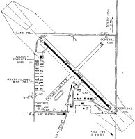
Runways
Runway Summary
| Runways: | 13/31 18/36 |
| Longest Runway: | 18/36 is 4600 ft (1402 m) long |
| Runways with an Instrument Approach: |
3K3 Airport Runway Details
| Runway 13/31 | 3000 ft x 40 ft (914 m x 12 m) | |
| Surface: | Asphalt - Good condition - No special surface treatment | |
| Runway Pavement Class: | 5 /F/C/Y/U | |
| Runway Edge Lights: | Medium Intensity | |
Runway 13 |
Runway 31 |
|
Elevation: |
3312.2 | 3303.0 |
Latitude: |
37-59-47.6060N | 37-59-26.6270N |
Longitude: |
101-45-03.7940W | 101-44-37.3060W |
|
Runway True Alignment: |
135 | 315 |
Glide Path Angle: |
0.0 degrees | 0.0 degrees |
Traffic Pattern: |
Left | Right |
Runway Markings Type: |
Basic | Basic |
Runway Markings Condition: |
Fair | Fair |
Object at End: |
ROAD | TREE |
Object Height: |
15 | 26 |
Distance from End: |
220 | 373 |
Object Centerline Offset: |
0 ft. left and right of centerline | 171 ft. left of centerline |
Threshold Elevation: |
3303.0 | |
Displaced Threshold: |
355 | |
Threshold Latitude: |
37-59-29.1100N | |
Threshold Longitude: |
101-44-40.4400W |
| Runway 18/36 | 4600 ft x 75 ft (1402 m x 23 m) | |
| Runway Length Source: | REGION as of 12/19/2006 | |
| Surface: | Asphalt - Good condition - No special surface treatment | |
| Runway Pavement Class: | 11 /R/C/X/U | |
| Runway Edge Lights: | Medium Intensity | |
Runway Weight Bearing Capacity (in thousands of pounds) |
||
| Single Wheel Landing Gear: | 30.0 | |
| Dual Wheel Landing Gear: | 30.0 | |
Runway 18 |
Runway 36 |
|
Elevation: |
3326.1 | 3314.9 |
Latitude: |
38-00-28.8900N | 37-59-44.0700N |
Longitude: |
101-44-47.0800W | 101-44-56.7900W |
|
Runway True Alignment: |
190 | 010 |
Glide Path Angle: |
3.0 degrees | 3.2 degrees |
Traffic Pattern: |
Right | |
Runway Markings Type: |
Nonprecision Instrument | Nonprecision Instrument |
Runway Markings Condition: |
Good | Good |
Object at End: |
PLINE | BLDG |
Object Height: |
55 | 25 |
Object Marked/Lighted?: |
Marked | |
Distance from End: |
1327 | 426 |
Object Centerline Offset: |
0 ft. left and right of centerline | 171 ft. left of centerline |
Visual Glide Slope Indicators: |
4-Light PAPI On Right Side Of Runway | 4-Light PAPI On Left Side Of Runway |
Threshold Crossing Height: |
35 | 44 |
Services
Airframe Repair: |
Minor |
Powerplant Repair: |
Minor |
Fuel Available: |
100LL |
Landing Fees: |
No |
Parking: |
Tiedowns available |
Maps & Diagrams
3K3 Sectional
Flight Planning
at skyvector.com
at skyvector.com