Location
Latitude: |
32-40-36.0299N (32.676675) |
Longitude: |
095-30-39.4492W (-95.510958) |
Elevation: |
430.0 feet MSL (131 m MSL) |
Magnetic Variation: |
1.9 E (as of April 2024 from WMM2020 model) |
Time Zone: |
UTC -6.0 (Standard Time) UTC -5.0 (Daylight Savings Time) |
From City: |
01 N.M. W of Mineola, Texas |
Found On: |
Dallas-Ft Worth Chart |
FAA Region: |
ASW |
Contacts
Manager: |
Privately owned: |
| LUPITA A. WISENER 1412 COUNTRY CLUB DRIVE MINEOLA, TX 75773 (903) 569-1929 |
R. H. WISENER P.O. BOX 65 MINEOLA, TX 75773 903-569-1929 |
Operations
Airport Status: |
Operational |
Facility Use: |
Public |
Type: |
Airport |
Activation Date: |
07/1941 |
Control tower: |
No |
Attendance (Months/Days/Hours): |
Months/Days/Hours ALL/ALL/ALL |
Boundary ARTCC: |
ZFW (Fort Worth) |
Responsible ARTCC: |
ZFW (Fort Worth) |
Lighting Schedule: |
SEE RMK |
Segmented Circle Indicator: |
No |
Traffic Pattern Altitude (MSL): |
1430 feet (436 m) |
NOTAMs Facility: |
FTW |
NOTAM-D Service: |
Yes |
International Airport of Entry: |
No |
Customs Landing Rights: |
No |
Civil/Military Joint Use: |
No |
Based Aircraft
| Single Engine: | 56 |
| Multi Engine: | 2 |
| Gliders: | 2 |
| Ultralights: | 4 |
Annual Operations (as of 10/03/2022)
| Total Operations: | 8500 | |
| GA Local: | 5000 | 58.8% |
| GA Itinerant: | 3500 | 41.2% |
Communications
| CTAF: | 122.800 |
| Unicom: | 122.800 |
| Approach: | LONGVIEW 128.75 128.75 FORT WORTH ARTCC |
| Departure: | LONGVIEW 128.75 128.75 FORT WORTH ARTCC |
- APCH/DEP SVC PRVDD BY FORT WORTH ARTCC (ZFW) ON FREQS 132.85/360.75 (CUMBY RCAG) WHEN LONGVIEW APCH CTL (GGG) CLSD.
Fixed Based Operators (FBOs) & Fuel
(Click on a business for detail)
Please help us keep this information up to date. This is a FREE SERVICE just like everything else on Airport Guide! If you see that a business needs to be added, modified, or deleted please fill out our Update Form.
To add, modify, or delete a business click here.
Please help us keep this information up to date. This is a FREE SERVICE just like everything else on Airport Guide! If you see that a business needs to be added, modified, or deleted please fill out our Update Form.
Area Code: 903 |
| Business Name | Frequency | Phone | Fuel Grade |
|---|---|---|---|
| Wisener Field Airport
Update FBO info |
Unicom 122.8 | 903-569-5275 | 100 |

|
 Independent |
100LL - 3.89 USD per on 5/14/2010 |
Self Serve Pumps |
Flight Service Stations
| Primary | Alternate | |
| FSS on Field: | N | |
| FSS Name (ID): | Fort Worth(FTW) | |
| Frequency: | ||
| Toll Free Phone: | 1-800-WX-BRIEF |
Instrument Procedures / Charts
| Page Type | Page Name | Volume | Action Since Last Cycle |
|---|
Terminal Procedures are only available for airports in several countries with more being added all the time. If you are looking for a specific country's charts, please send an email to support(at)airportguide.com stating the country name. This will be used to prioritize the implementation.
Navigation Aids (Navaids) near 3F9
| Dist (NM) | ID | Morse Code | Name | Type | Freq | True Hdg | Mag Hdg |
|---|---|---|---|---|---|---|---|
| 14.2 | UIM | . . _ . . _ _ | Quitman | DME | 114 | 30 | 28 |
| 15.8 | TY | _ _ . _ _ | Indoo | NDB | 320 | 172 | 170 |
| 20.0 | TYR | _ _ . _ _ . _ . | Tyler | VOR-DME | 114.20 | 164 | 162 |
| 20.8 | ABG | . _ _ . . . _ _ . | Ambassador | NDB | 404 | 105 | 103 |
| 31.4 | SLR | . . . . _ . . . _ . | Sulphur Springs | DME | 109 | 357 | 355 |
| 33.5 | SYW | . . . _ . _ _ . _ _ | Cash | NDB | 428 | 303 | 301 |
| 35.0 | AHX | . _ . . . . _ . . _ | Athens | NDB | 269 | 207 | 205 |
| 36.1 | FZT | . . _ . _ _ . . _ | Frankston | VOR-DME | 111.40 | 181 | 179 |
| 36.3 | MJF | _ _ . _ _ _ . . _ . | Arvilla | TACAN | 109.60 | 310 | 308 |
| 37.6 | AVZ | . _ . . . _ _ _ . . | Travis | NDB | 260 | 277 | 275 |
| 38.4 | GG | _ _ . _ _ . | Veels | NDB | 410 | 110 | 108 |
| 41.4 | GGG | _ _ . _ _ . _ _ . | Gregg County | VORTAC | 112.90 | 111 | 109 |
| 43.1 | MII | _ _ . . . . | Caddo Mills | NDB | 316 | 300 | 298 |
| 43.2 | CSZ | _ . _ . . . . _ _ . . | Crossroads | NDB | 215 | 211 | 209 |
| 44.1 | HNO | . . . . _ . _ _ _ | Henderson | NDB | 371 | 131 | 129 |
| 46.4 | CQY | _ . _ . _ _ . _ _ . _ _ | Cedar Creek | VORTAC | 114.80 | 230 | 228 |
| 50.7 | JSO | . _ _ _ . . . _ _ _ | Cherokee County | NDB | 263 | 162 | 160 |
| 51.6 | JUG | . _ _ _ . . _ _ _ . | Jecca | NDB | 388 | 269 | 267 |
| 52.0 | PQF | . _ _ . _ _ . _ . . _ . | Mesquite | NDB | 248 | 279 | 277 |
| 52.0 | PRX | . _ _ . . _ . _ . . _ | Paris | VOR-DME | 113.60 | 3 | 1 |
Nearby Airports with Fuel
Notices to Airmen (NOTAMS)
Remarks
| A110-1 | FOR CD CTC FORT WORTH ARTCC AT 817-858-7584. |
| A14 | AMGR LIVES ADJ. |
| A33-18L/36R | RWY SFC HAS SOME LOOSE AGGREGATE AND SEVERAL ROUGH PATCHES AT THRS. |
| A40-18L/36R | THR AT BOTH RWY ENDS MKD BY TWO RED LGTS. |
| A51-18L | MKD THR DSPLCD 140 FT. |
| A51-36R | MKD THR DSPLCD 140 FT. |
| A57-18L | APCH RATIO 3:1 AT THR LTS OVR 80 FT TREES, 344 DSTC, 80 FT R. |
| A58-18L | +4 FT FENCE, 15 FT ROAD AT THR ACRS APCH 5 FT DSTC. |
| A58-36R | 15 FT RD, 4 FT FENCE AT THR. 80 FT TREES 60 FT DSTC 125 FT L. |
| A70-FUEL-10 | 0LL FUEL SELF-SVC. |
| A81-APT | ACTVT LIRL RWY 18L/36R - CTAF. |
| E111 | PRE DATES THE ACT. |
Runways
Runway Summary
| Runways: | 18L/36R 18R/36L |
| Longest Runway: | 18R/36L is 3234 ft (986 m) long |
| Runways with an Instrument Approach: |
3F9 Airport Runway Details
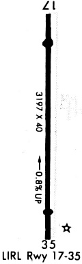
| Runway 18L/36R | 3203 ft x 40 ft (976 m x 12 m) | |
| Runway Length Source: | OWNER as of 11/01/2016 | |
| Surface: | Asphalt - Poor condition - No special surface treatment | |
| Runway Edge Lights: | Low Intensity | |
Runway Weight Bearing Capacity (in thousands of pounds) |
||
| Single Wheel Landing Gear: | 10.0 | |
Runway 18L |
Runway 36R |
|
Elevation: |
429.3 | 403.9 |
Latitude: |
32-40-51.9020N | 32-40-20.2180N |
Longitude: |
095-30-38.6980W | 095-30-39.0880W |
|
Runway True Alignment: |
181 | 001 |
Glide Path Angle: |
0.0 degrees | 0.0 degrees |
Traffic Pattern: |
Left | Left |
Runway Markings Type: |
Basic | Basic |
Runway Markings Condition: |
Good | Good |
Object at End: |
TREES | TREES |
Object Height: |
80 | 80 |
Distance from End: |
201 | 201 |
Object Centerline Offset: |
65 ft. right of centerline | 125 ft. left and right of centerline |
| Runway 18R/36L | 3234 ft x 60 ft (986 m x 18 m) | |
| Runway Length Source: | OWNER as of 11/01/2016 | |
| Surface: | Asphalt - Poor condition - No special surface treatment | |
Runway 18R |
Runway 36L |
|
Elevation: |
429.0 | 430.0 |
Latitude: |
32-40-52.0000N | 32-40-20.0000N |
Longitude: |
095-30-40.0000W | 095-30-40.0000W |
|
Runway True Alignment: |
180 | 000 |
Glide Path Angle: |
0.0 degrees | 0.0 degrees |
Runway Markings Type: |
None | None |
Runway Markings Condition: |
Good | Good |
Object at End: |
TREES | TREES |
Object Height: |
80 | 50 |
Distance from End: |
0 | 0 |
Object Centerline Offset: |
65 ft. right of centerline | 125 ft. left and right of centerline |
Services
Airframe Repair: |
Major |
Powerplant Repair: |
Major |
Bottled Oxygen: |
High Pressure / Low Pressure |
Bulk Oxygen: |
High Pressure / Low Pressure |
Fuel Available: |
100LL, Jet A |
Landing Fees: |
No |
Parking: |
Hangars and tiedowns available |
Maps & Diagrams
3F9 Sectional
Flight Planning
at skyvector.com
at skyvector.com