Location
Latitude: |
44-43-23.9000N (44.723306) |
Longitude: |
115-00-14.3000W (-115.003972) |
Elevation: |
4415.0 feet MSL (1346 m MSL) |
Magnetic Variation: |
12.7 E (as of April 2024 from WMM2020 model) |
Time Zone: |
UTC -7.0 (Standard Time) UTC -6.0 (Daylight Savings Time) |
From City: |
31 N.M. N of Stanley, Idaho |
Found On: |
Great Falls Chart |
FAA Region: |
ANM |
Contacts
Manager: |
Publicly owned: |
| ID DIV OF AERONAUTICS PO BOX 7129 BOISE, ID 83707-1129 208-334-8775 |
STATE OF ID, ITD, DIV AERO PO BOX 7129 BOISE, ID 83707-1129 208-334-8775 |
Operations
Airport Status: |
Operational |
Facility Use: |
Public |
Type: |
Airport |
Activation Date: |
07/1958 |
Control tower: |
No |
Attendance (Months/Days/Hours): |
Months/Days/Hours Unattended |
Boundary ARTCC: |
ZLC (Salt Lake City) |
Responsible ARTCC: |
ZLC (Salt Lake City) |
Segmented Circle Indicator: |
No |
Traffic Pattern Altitude (MSL): |
5415 feet (1650 m) |
NOTAMs Facility: |
BOI |
NOTAM-D Service: |
Yes |
Military Landing Rights: |
No |
Civil/Military Joint Use: |
No |
Based Aircraft
Annual Operations (as of 06/30/2022)
| Total Operations: | 2350 | |
| Air Taxi: | 1600 | 68.1% |
| GA Itinerant: | 750 | 31.9% |
Communications
| CTAF: | 122.900 |
Fixed Based Operators (FBOs) & Fuel
(Click on a business for detail)
Please help us keep this information up to date. This is a FREE SERVICE just like everything else on Airport Guide! If you see that a business needs to be added, modified, or deleted please fill out our Update Form.
To add, modify, or delete a business click here.
Please help us keep this information up to date. This is a FREE SERVICE just like everything else on Airport Guide! If you see that a business needs to be added, modified, or deleted please fill out our Update Form.
Area Code: 208 |
| Business Name | Frequency | Phone | Fuel Grade |
|---|
Flight Service Stations
| Primary | Alternate | |
| FSS on Field: | N | |
| FSS Name (ID): | Boise(BOI) | |
| Frequency: | ||
| Toll Free Phone: | 1-800-WX-BRIEF |
Instrument Procedures / Charts
Terminal Procedures are only available for airports in several countries with more being added all the time. If you are looking for a specific country's charts, please send an email to support(at)airportguide.com stating the country name. This will be used to prioritize the implementation.
Navigation Aids (Navaids) near 2U8
| Dist (NM) | ID | Morse Code | Name | Type | Freq | True Hdg | Mag Hdg |
|---|---|---|---|---|---|---|---|
| 43.0 | LKT | . _ . . _ . _ _ | Salmon | VOR-DME | 113.50 | 65 | 52 |
| 51.3 | DNJ | _ . . _ . . _ _ _ | Donnelly | VOR-DME | 116.20 | 273 | 260 |
| 86.9 | BOI | _ . . . _ _ _ . . | Boise | VORTAC | 113.30 | 216 | 203 |
| 87.4 | BOI | _ . . . _ _ _ . . | Boise | VOT | 116.70 | 217 | 204 |
| 88.0 | BO | _ . . . _ _ _ | Ustik | NDB | 359 | 220 | 207 |
| 89.8 | HLE | . . . . . _ . . . | Hailey | NDB-DME | 220 | 158 | 146 |
| 94.2 | MPA | _ _ . _ _ . . _ | Meridian | NDB | 238 | 225 | 212 |
| 95.8 | ONO | _ _ _ _ . _ _ _ | Ontario | NDB | 305 | 244 | 231 |
Nearby Airports with Fuel
Notices to Airmen (NOTAMS)
Remarks
| A110-1 | RCMD LNDG RY 21-TKOF RY 03; GO-AROUND EXTREMELY DIFICULT. |
| A110-2 | NO WINTER MAINTENANCE. |
| A110-3 | AIRCRAFT LOADING AND UNLOADING AT THE SOUTH END OF RY 21. |
| A110-4 | RY 03 FIRST 400 FT IS DOG LEG WITH A HEADING OF 360 DEG. |
| A110-5 | CONSIDERABLE AIR TAXI OPERATIONS MID TO LATE SUMMER. |
| A110-6 | ARPT IS LCTD ON PLATEAU 100-150 FT ABOVE RIVER. |
| A110-7 | FOR CD CTC SALT LAKE ARTCC AT 801-320-2568. |
| A32-03/21 | USBL WIDTH MAY VARY FM 75 FT TO 100 FT. |
| A52-03 | +100' RIDGE 250' ON CNTRLN. |
| A52-21 | NUMEROUS TALL TREES ALONG RIVER ON APCH TO RY 21. |
| E111 | ESTABD PRIOR TO 12/31/58. |
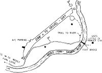
Runways
Runway Summary
| Runways: | 03/21 |
| Longest Runway: | 03/21 is 2100 ft (640 m) long |
| Runways with an Instrument Approach: |
2U8 Airport Runway Details
| Runway 03/21 | 2100 ft x 75 ft (640 m x 23 m) | |
| Surface: | Turf/Dirt - Good condition - No special surface treatment | |
Runway 03 |
Runway 21 |
|
Elevation: |
4415.0 | 4363.0 |
Latitude: |
44-43-16.1989N | 44-43-31.6519N |
Longitude: |
115-00-23.9556W | 115-00-04.5502W |
|
Runway True Alignment: |
042 | 222 |
Glide Path Angle: |
0.0 degrees | 0.0 degrees |
Traffic Pattern: |
Left | Left |
Object at End: |
HILL | TREE |
Object Height: |
100 | 20 |
Distance from End: |
100 | 150 |
Object Centerline Offset: |
125 ft. left of centerline | 40 ft. left of centerline |
Services
Bottled Oxygen: |
None |
Bulk Oxygen: |
None |
Fuel Available: |
100LL |
Landing Fees: |
No |
Parking: |
Tiedowns available |
Maps & Diagrams
2U8 Sectional
Flight Planning
at skyvector.com
at skyvector.com