Location
Latitude: |
30-35-52.3910N (30.597886) |
Longitude: |
084-33-26.7850W (-84.55744) |
Elevation: |
221.2 feet MSL (67 m MSL) |
Magnetic Variation: |
5.1 W (as of April 2024 from WMM2020 model) |
Time Zone: |
UTC -5.0 (Standard Time) UTC -4.0 (Daylight Savings Time) |
From City: |
02 N.M. NE of Quincy, Florida |
Found On: |
Jacksonville Chart |
FAA Region: |
ASO |
Contacts
Manager: |
Publicly owned: |
| JANICE WATSON 1300 AIRPORT DR QUINCY, FL 32352 850-643-7752 |
QUINCY GADSDEN AIRPORT AUTHORITY PO BOX 1905 QUINCY, FL 32353 850-627-2112 |
Operations
Airport Status: |
Operational |
Facility Use: |
Public |
Type: |
Airport |
Activation Date: |
04/1940 |
Control tower: |
No |
Attendance (Months/Days/Hours): |
Months/Days/Hours ALL/ALL/0800-DUSK |
Boundary ARTCC: |
ZJX (Jacksonville) |
Responsible ARTCC: |
ZJX (Jacksonville) |
Lighting Schedule: |
SEE RMK |
Segmented Circle Indicator: |
Yes |
Traffic Pattern Altitude (MSL): |
1221 feet (372 m) |
NOTAMs Facility: |
GNV |
NOTAM-D Service: |
Yes |
International Airport of Entry: |
No |
Customs Landing Rights: |
No |
Military Landing Rights: |
No |
Civil/Military Joint Use: |
No |
Based Aircraft
| Single Engine: | 68 |
| Multi Engine: | 2 |
| Gliders: | 2 |
Annual Operations (as of 03/05/2018)
| Total Operations: | 6240 | |
| GA Local: | 4056 | 65.0% |
| GA Itinerant: | 2184 | 35.0% |
Communications
| CTAF: | 122.700 |
| Unicom: | 122.700 |
| Approach: | TALLAHASSEE 128.7 128.7 JAX ARTCC |
| Departure: | TALLAHASSEE 128.7 128.7 JAX ARTCC |
| AWOS-3PT: | 118.975 (850-627-6264) |
- APCH/DEP SVC PRVDD BY JAX ARTCC ON FREQS 128.625/379.175 (TALLAHASSEE RCAG) WHEN TALLAHASSEE APCH CTL CLSD.
Fixed Based Operators (FBOs) & Fuel
(Click on a business for detail)
Please help us keep this information up to date. This is a FREE SERVICE just like everything else on Airport Guide! If you see that a business needs to be added, modified, or deleted please fill out our Update Form.
To add, modify, or delete a business click here.
Please help us keep this information up to date. This is a FREE SERVICE just like everything else on Airport Guide! If you see that a business needs to be added, modified, or deleted please fill out our Update Form.
Area Code: 850 |
| Business Name | Frequency | Phone | Fuel Grade |
|---|
Flight Service Stations
| Primary | Alternate | |
| FSS on Field: | N | |
| FSS Name (ID): | Gainesville(GNV) | |
| Frequency: | ||
| Toll Free Phone: | 1-800-WX-BRIEF |
Instrument Procedures / Charts
FAA Terminal Procedures valid from 0901Z 03/21/24 to 0901Z 04/18/24.
There are various types of charts available for an airport. They are listed in the Page Type column. Here is a legend for those types:
APD - Airport Diagram
DP - Departure Procedure Charts
HOT - Hot Spots
IAP - Instrument Approach Procedure Charts
MIN - Minimums
STAR - Standard Terminal Arrival Charts
| Page Type | Page Name | Volume | Action Since Last Cycle |
|---|---|---|---|
| IAP | RNAV (GPS)-A | SE-3 | |
| MIN | ALTERNATE MINIMUMS | SE-3 | |
| MIN | TAKEOFF MINIMUMS | SE-3 |
Terminal Procedures are only available for airports in several countries with more being added all the time. If you are looking for a specific country's charts, please send an email to support(at)airportguide.com stating the country name. This will be used to prioritize the implementation.
Navigation Aids (Navaids) near 2J9
| Dist (NM) | ID | Morse Code | Name | Type | Freq | True Hdg | Mag Hdg |
|---|---|---|---|---|---|---|---|
| 9.8 | SZW | . . . _ _ . . . _ _ | Seminole | VORTAC | 117.50 | 104 | 109 |
| 16.4 | TLH | _ . _ . . . . . . | Tallahassee Muni | VOT | 111.00 | 140 | 145 |
| 19.3 | TL | _ . _ . . | Wakul | NDB | 379 | 147 | 152 |
| 22.5 | LYZ | . _ . . _ . _ _ _ _ . . | Willis | NDB | 359 | 4 | 9 |
| 26.9 | CYR | _ . _ . _ . _ _ . _ . | Caidy | NDB | 338 | 49 | 54 |
| 31.4 | MAI | _ _ . _ . . | Marianna | VORTAC | 114.00 | 291 | 296 |
| 38.1 | SMY | . . . _ _ _ . _ _ | Soyya | NDB | 329 | 295 | 300 |
| 40.1 | GEF | _ _ . . . . _ . | Greenville | VORTAC | 113.65 | 93 | 98 |
| 40.5 | CXU | _ . _ . _ . . _ . . _ | Camilla | NDB | 369 | 23 | 28 |
| 43.4 | GTP | _ _ . _ . _ _ . | Paton | NDB | 245 | 60 | 65 |
| 48.5 | MGR | _ _ _ _ . . _ . | Moultrie | DME | 108.8 | 52 | 57 |
| 53.2 | IWJ | . . . _ _ . _ _ _ | Blaak | NDB | 344 | 345 | 350 |
| 53.5 | AB | . _ _ . . . | Putny | NDB | 227 | 15 | 20 |
| 55.9 | BKK | _ . . . _ . _ _ . _ | Tri County | NDB | 275 | 286 | 291 |
| 57.9 | AAF | . _ . _ . . _ . | Apalachicola | NDB | 349 | 205 | 210 |
| 61.0 | RRS | . _ . . _ . . . . | Wiregrass | VORTAC | 111.60 | 312 | 317 |
| 61.2 | PAM | . _ _ . . _ _ _ | Tyndall | TACAN | 133.70 | 239 | 244 |
| 64.9 | PZD | . _ _ . _ _ . . _ . . | Pecan | VOR-DME | 116.10 | 12 | 17 |
| 65.4 | PFN | . _ _ . . . _ . _ . | Lynne | NDB | 278 | 255 | 260 |
| 66.8 | OTK | _ _ _ _ _ . _ | Valdosta | VOR-DME | 114.80 | 80 | 86 |
Nearby Airports with Fuel
Notices to Airmen (NOTAMS)
Remarks
| A11 | JANICE WATSON |
| A110-4 | PAJA OPS; GLIDER OPS BLW 10000 FT ON & INVOF ARPT. |
| A110-7 | DEER INVOF MOVEMENT AREAS. |
| A110-9 | FOR CD CTC TALLAHASSEE APCH AT 850-942-8311, WHEN APCH CLSD CTC JACKSONVILLE ARTCC AT 904-845-1592. |
| A30A-14 | APCH SLOPE 26:1 TO THE DSPLCD THR. |
| A57-14 | RWY 32 APCH SLOPE 25:1 TO THE DTHR. |
| A81-APT | ACTVT PAPI RWY 14 & 32; MIRL RWY 14/32 - CTAF. |
| E111 | EXISTED PRIOR TO 1959. |
Runways
Runway Summary
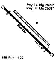
| Runways: | 14/32 |
| Longest Runway: | 14/32 is 2974 ft (906 m) long |
| Runways with an Instrument Approach: |
2J9 Airport Runway Details
| Runway 14/32 | 2974 ft x 75 ft (906 m x 23 m) | |
| Runway Length Source: | 3RD PARTY SURVEY as of 10/25/2018 | |
| Surface: | Asphalt - Excellent condition - No special surface treatment | |
| Runway Pavement Class: | 9 /F/A/Y/T | |
| Runway Edge Lights: | Medium Intensity | |
Runway Weight Bearing Capacity (in thousands of pounds) |
||
| Single Wheel Landing Gear: | 20.0 | |
Runway 14 |
Runway 32 |
|
Elevation: |
221.1 | 203.4 |
Latitude: |
30-36-02.8946N | 30-35-41.8862N |
Longitude: |
084-33-38.7010W | 084-33-14.8690W |
|
Runway True Alignment: |
136 | 316 |
Glide Path Angle: |
3.0 degrees | 3.0 degrees |
Traffic Pattern: |
Right | Left |
Runway Markings Type: |
Nonprecision Instrument | Nonprecision Instrument |
Runway Markings Condition: |
Good | Good |
Object at End: |
TREES | TREES |
Object Height: |
70 | 41 |
Distance from End: |
1605 | 925 |
Object Centerline Offset: |
160 ft. right of centerline | 110 ft. right of centerline |
Visual Glide Slope Indicators: |
2-Light PAPI On Right Side Of Runway | 2-Light PAPI On Left Side Of Runway |
Threshold Crossing Height: |
20 | 21 |
Threshold Elevation: |
221.1 | 207.5 |
Displaced Threshold: |
267 | 322 |
Threshold Latitude: |
30-36-01.0029N | 30-35-44.1543N |
Threshold Longitude: |
084-33-36.5622W | 084-33-17.4513W |
Declared Distances |
||
Take Off Run Avbl. (TORA): |
2964 | 2964 |
Take Off Distance Avbl. (TODA): |
2964 | 2964 |
Actual Stop Dist. Avbl. (ASDA): |
2964 | 2755 |
Landing Dist. Avbl. (LDA): |
2700 | 2431 |
Services
Airframe Repair: |
None |
Powerplant Repair: |
None |
Bottled Oxygen: |
None |
Bulk Oxygen: |
None |
Fuel Available: |
100LL |
Landing Fees: |
No |
Parking: |
Tiedowns available |
Maps & Diagrams
2J9 Sectional
Flight Planning
at skyvector.com
at skyvector.com