Location
Latitude: |
38-22-22.2250N (38.37284) |
Longitude: |
098-35-55.1150W (-98.598643) |
Elevation: |
1797.0 feet MSL (548 m MSL) |
Magnetic Variation: |
3.9 E (as of April 2024 from WMM2020 model) |
Time Zone: |
UTC -6.0 (Standard Time) UTC -5.0 (Daylight Savings Time) |
From City: |
02 N.M. NW of Ellinwood, Kansas |
Found On: |
Wichita Chart |
FAA Region: |
ACE |
Contacts
Manager: |
Publicly owned: |
| CHRIS KOMAREK PO BOX 278 ELLINWOOD, KS 67526 620-564-3161 |
CITY ELLINWOOD PO BOX 278 ELLINWOOD, KS 67526 620-564-3161 |
Operations
Airport Status: |
Operational |
Facility Use: |
Public |
Type: |
Airport |
Activation Date: |
03/1945 |
Control tower: |
No |
Attendance (Months/Days/Hours): |
Months/Days/Hours Unattended |
Boundary ARTCC: |
ZKC (Kansas City) |
Responsible ARTCC: |
ZKC (Kansas City) |
Lighting Schedule: |
SS-SR |
Segmented Circle Indicator: |
No |
Traffic Pattern Altitude (MSL): |
2797 feet (853 m) |
NOTAMs Facility: |
ICT |
NOTAM-D Service: |
Yes |
Based Aircraft
| Single Engine: | 5 |
| Ultralights: | 2 |
Annual Operations (as of 06/17/2020)
| Total Operations: | 1150 | |
| GA Local: | 1000 | 87.0% |
| GA Itinerant: | 150 | 13.0% |
Communications
| CTAF: | 122.900 |
Fixed Based Operators (FBOs) & Fuel
(Click on a business for detail)
Please help us keep this information up to date. This is a FREE SERVICE just like everything else on Airport Guide! If you see that a business needs to be added, modified, or deleted please fill out our Update Form.
To add, modify, or delete a business click here.
Please help us keep this information up to date. This is a FREE SERVICE just like everything else on Airport Guide! If you see that a business needs to be added, modified, or deleted please fill out our Update Form.
Area Code: 620 |
| Business Name | Frequency | Phone | Fuel Grade |
|---|---|---|---|
| Ellinwood Flying Service
Update FBO info |
534-2508 | 100LL |
Flight Service Stations
| Primary | Alternate | |
| FSS on Field: | N | |
| FSS Name (ID): | Wichita(ICT) | |
| Frequency: | ||
| Toll Free Phone: | 1-800-WX-BRIEF |
Instrument Procedures / Charts
Terminal Procedures are only available for airports in several countries with more being added all the time. If you are looking for a specific country's charts, please send an email to support(at)airportguide.com stating the country name. This will be used to prioritize the implementation.
Navigation Aids (Navaids) near 1K6
| Dist (NM) | ID | Morse Code | Name | Type | Freq | True Hdg | Mag Hdg |
|---|---|---|---|---|---|---|---|
| 14.1 | GB | _ _ . _ . . . | Babsy | NDB | 419 | 239 | 235 |
| 14.3 | HIL | . . . . . . . _ . . | Hilyn | NDB | 338 | 266 | 262 |
| 17.6 | LYO | . _ . . _ . _ _ _ _ _ | Lyons | NDB | 386 | 94 | 90 |
| 25.2 | LQR | . _ . . _ _ . _ . _ . | Larned | NDB | 296 | 246 | 242 |
| 35.0 | HU | . . . . . . _ | Saltt | NDB | 404 | 115 | 111 |
| 38.6 | HUT | . . . . . . _ _ | Hutchinson | VOR-DME | 116.80 | 125 | 121 |
| 38.8 | HY | . . . . _ . _ _ | Nette | NDB | 374 | 308 | 304 |
| 39.4 | PTT | . _ _ . _ _ | Pratt | NDB | 356 | 190 | 186 |
| 42.7 | HYS | . . . . _ . _ _ . . . | Hays | VORTAC | 110.40 | 312 | 308 |
| 42.9 | MPR | _ _ . _ _ . . _ . | Mc Pherson | NDB | 227 | 91 | 87 |
| 48.4 | SL | . . . . _ . . | Flory | NDB | 344 | 67 | 63 |
| 56.5 | SLN | . . . . _ . . _ . | Salina | VORTAC | 117.10 | 53 | 49 |
| 61.0 | ICT | . . _ . _ . _ | Wichita | VORTAC | 113.80 | 127 | 123 |
| 63.8 | CA | _ . _ . . _ | Harvs | NDB | 395 | 101 | 98 |
| 65.2 | EWK | . . _ _ _ . _ | Newton | NDB | 281 | 106 | 103 |
| 70.6 | ICT | . . _ . _ . _ | Wichita | VOT | 114.00 | 128 | 125 |
| 72.1 | IC | . . _ . _ . | Piche | NDB | 332 | 131 | 128 |
| 73.4 | DDC | _ . . _ . . _ . _ . | Dodge City | VORTAC | 108.20 | 245 | 241 |
| 75.6 | ANY | . _ _ . _ . _ _ | Anthony | TACAN | 112.90 | 164 | 160 |
| 77.4 | IAB | . . . _ _ . . . | Mc Connell | TACAN | 116.50 | 125 | 122 |
Nearby Airports with Fuel
Notices to Airmen (NOTAMS)
Remarks
| A110-1 | 2 FT DITCH AT RWY 26 THRESHOLD NOT MKD |
| A110-2 | LARGE DRAINAGE DITCH 400 FT SOUTH OF RWY 35 |
| A110-3 | FOR CD CTC KANSAS CITY ARTCC AT 913-254-8508. |
| A14 | AFTER HOURS CONTACT CITY OF ELLINWOOD 620-564-2211 |
| A33-08/26 | VERY SOFT AFTER RAIN. |
| A33-17/35 | PATCHES OF GRASSY VEGETATION/GRAVEL MIXTURE AER 17 ALONG CNTRLN. |
| A52-26 | ROAD AT 70 FT LEFT CNTRLN OF RY 26. POWER LINE UNDERGROUND IN APCH PATH. |
| E111 | ARPT CONSTRUCTED PRIOR TO 1959. |
Runways
Runway Summary
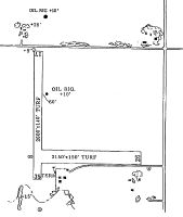
| Runways: | 08/26 17/35 |
| Longest Runway: | 17/35 is 2550 ft (777 m) long |
| Runways with an Instrument Approach: |
1K6 Airport Runway Details
| Runway 08/26 | 2150 ft x 150 ft (655 m x 46 m) | |
| Surface: | Turf - Good condition - No special surface treatment | |
Runway 08 |
Runway 26 |
|
Glide Path Angle: |
0.0 degrees | 0.0 degrees |
Traffic Pattern: |
Left | Left |
Object at End: |
ROAD | |
Object Height: |
15 | |
Distance from End: |
155 | |
Object Centerline Offset: |
0 ft. left and right of centerline |
| Runway 17/35 | 2550 ft x 100 ft (777 m x 30 m) | |
| Surface: | Turf - Good condition - No special surface treatment | |
| Runway Edge Lights: | Medium Intensity | |
Runway 17 |
Runway 35 |
|
Latitude: |
38-22-34.8300N | 38-22-09.6200N |
Longitude: |
098-35-55.3900W | 098-35-54.8400W |
Glide Path Angle: |
0.0 degrees | 0.0 degrees |
Traffic Pattern: |
Left | Left |
Object at End: |
ROAD | |
Object Height: |
15 | |
Distance from End: |
95 | |
Object Centerline Offset: |
0 ft. left and right of centerline |
Services
Airframe Repair: |
Major |
Powerplant Repair: |
Major |
Bottled Oxygen: |
None |
Bulk Oxygen: |
None |
Fuel Available: |
100LL |
Landing Fees: |
No |
Parking: |
Hangars and tiedowns available |
Maps & Diagrams
1K6 Sectional
Flight Planning
at skyvector.com
at skyvector.com