Location
Latitude: |
40-28-33.5600N (40.475989) |
Longitude: |
080-37-41.0150W (-80.62806) |
Elevation: |
1067.0 feet MSL (325 m MSL) |
Magnetic Variation: |
8.9 W (as of April 2024 from WMM2020 model) |
Time Zone: |
UTC -5.0 (Standard Time) UTC -4.0 (Daylight Savings Time) |
From City: |
02 N.M. NW of Toronto, Ohio |
Found On: |
Detroit Chart |
FAA Region: |
AGL |
Contacts
Manager: |
Privately owned: |
| RICH GRANTONIC 645 MCLISTER AVE MINGO JUNCTION, OH 43938-1285 740-632-3332 |
EDDIE DEW MEML AIRPARK 611 TOWNSHIP HIGHWAY 245 TORONTO, OH 43964-7850 740-632-3332 |
Operations
Airport Status: |
Operational |
Facility Use: |
Public |
Type: |
Airport |
Activation Date: |
12/1937 |
Control tower: |
No |
Attendance (Months/Days/Hours): |
Months/Days/Hours IREG |
Boundary ARTCC: |
ZOB (Cleveland) |
Responsible ARTCC: |
ZOB (Cleveland) |
Lighting Schedule: |
SEE RMK |
Segmented Circle Indicator: |
No |
Traffic Pattern Altitude (MSL): |
2067 feet (630 m) |
NOTAMs Facility: |
CLE |
NOTAM-D Service: |
Yes |
Based Aircraft
| Single Engine: | 14 |
| Ultralights: | 2 |
Annual Operations (as of 06/01/2023)
| Total Operations: | 450 | |
| GA Local: | 400 | 88.9% |
| GA Itinerant: | 50 | 11.1% |
Communications
| CTAF: | 122.900 |
Fixed Based Operators (FBOs) & Fuel
(Click on a business for detail)
Please help us keep this information up to date. This is a FREE SERVICE just like everything else on Airport Guide! If you see that a business needs to be added, modified, or deleted please fill out our Update Form.
To add, modify, or delete a business click here.
Please help us keep this information up to date. This is a FREE SERVICE just like everything else on Airport Guide! If you see that a business needs to be added, modified, or deleted please fill out our Update Form.
Area Code: 740 |
| Business Name | Frequency | Phone | Fuel Grade |
|---|---|---|---|
| Eddie Dew Memorial Airpark, Inc.
Update FBO info |
537-9107, 282-0075 |
Flight Service Stations
| Primary | Alternate | |
| FSS on Field: | N | |
| FSS Name (ID): | Cleveland(CLE) | |
| Frequency: | ||
| Toll Free Phone: | 1-800-WX-BRIEF |
Instrument Procedures / Charts
Terminal Procedures are only available for airports in several countries with more being added all the time. If you are looking for a specific country's charts, please send an email to support(at)airportguide.com stating the country name. This will be used to prioritize the implementation.
Navigation Aids (Navaids) near 1G8
| Dist (NM) | ID | Morse Code | Name | Type | Freq | True Hdg | Mag Hdg |
|---|---|---|---|---|---|---|---|
| 13.2 | HLG | . . . . . _ . . _ _ . | Wheeling | VOR-DME | 114.25 | 168 | 177 |
| 19.8 | MMJ | _ _ _ _ . _ _ _ | Montour | DME | 112 | 87 | 96 |
| 22.7 | CFX | _ . _ . . . _ . _ . . _ | Cadiz | NDB | 239 | 230 | 239 |
| 28.2 | EWC | . . _ _ _ . _ . | Ellwood City | VOR-DME | 115.80 | 42 | 51 |
| 28.9 | AIR | . _ . . . _ . | Bellaire | VOR-DME | 117.10 | 197 | 206 |
| 29.3 | AGC | . _ _ _ . _ . _ . | Allegheny | VOR-DME | 110.00 | 113 | 122 |
| 34.2 | UCP | . . _ _ . _ . . _ _ . | Castle | NDB | 272 | 16 | 25 |
| 39.4 | MKP | _ _ _ . _ . _ _ . | Mc Keesport | NDB | 287 | 100 | 109 |
| 39.9 | BSV | _ . . . . . . . . . _ | Briggs | VOR-DME | 112.40 | 293 | 302 |
| 40.9 | HBD | . . . . _ . . . _ . . | Hubbard | NDB | 408 | 6 | 15 |
| 41.5 | CTW | _ . _ . _ . _ _ | Newcomerstown | DME | 111.8 | 249 | 258 |
| 43.5 | YN | _ . _ _ _ . | Fetch | NDB | 338 | 1 | 10 |
| 45.5 | CAK | _ . _ . . _ _ . _ | Akron/Canton Regional | VOT | 110.60 | 305 | 314 |
| 46.0 | ACO | . _ _ . _ . _ _ _ | Akron | VOR-DME | 114.40 | 325 | 334 |
| 49.6 | AK | . _ _ . _ | Akron | NDB | 362 | 316 | 325 |
| 51.3 | YNG | _ . _ _ _ . _ _ . | Youngstown | VORTAC | 109.00 | 357 | 366 |
| 53.9 | VV | . . . _ . . . _ | Camor | NDB | 299 | 131 | 140 |
| 56.9 | MLR | _ _ . _ . . . _ . | Millersburg/Dcmsnd | NDB | 382 | 274 | 283 |
| 62.2 | BHU | _ . . . . . . . . . _ | Benje | NDB | 382 | 95 | 104 |
| 65.5 | MGW | _ _ _ _ . . _ _ | Morgantown | VOR-DME | 111.60 | 147 | 156 |
Nearby Airports with Fuel
Notices to Airmen (NOTAMS)
Remarks
| A110-1 | DEER, BIRDS, & OTR WILDLIFE ON & INVOF ARPT. |
| A110-2 | FOR CD CTC PITTSBURGH APCH AT 412-472-5591. |
| A14 | RICHG645@GMAIL.COM. |
| A16 | ADNL CTC MIKE BAUMAN 740-512-9002. |
| A40-17/35 | NSTD LIRL DUE TO 360 DEG GREEN LGTS AT RWY ENDS. |
| A52-17 | ALSO +15 FT ROAD, 35 FT DIST, 90 FT L & R, 2:1 SLP; +15 FT ROAD, 55 FT DIST, ON CL, 5:1 SLP. |
| A57-17 | CTLG OBSTN EXCEEDS A 45 DEG SLP. |
| A75 | ROPES NOT PRVDD. |
| A81-APT | ACTVT NSTD LIRL RWY 16/34 - CTAF. |
| E111 | ESTABD BFR 1959. |
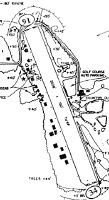
Runways
Runway Summary
| Runways: | 17/35 |
| Longest Runway: | 17/35 is 2268 ft (691 m) long |
| Runways with an Instrument Approach: |
1G8 Airport Runway Details
| Runway 17/35 | 2268 ft x 145 ft (691 m x 44 m) | |
| Runway Length Source: | OWNER as of 03/11/2021 | |
| Surface: | Turf - Fair condition - No special surface treatment | |
| Runway Edge Lights: | Non-standard lighting system Intensity | |
Runway 17 |
Runway 35 |
|
Elevation: |
1059.0 | 1067.0 |
Latitude: |
40-28-44.0700N | 40-28-23.0500N |
Longitude: |
080-37-46.1000W | 080-37-35.9300W |
|
Runway True Alignment: |
160 | 340 |
Glide Path Angle: |
0.0 degrees | 0.0 degrees |
Traffic Pattern: |
Left | Left |
Object at End: |
TREES | TREES |
Object Height: |
55 | 77 |
Distance from End: |
0 | 35 |
Object Centerline Offset: |
100 ft. left of centerline | 100 ft. right of centerline |
REIL: |
No | No |
Touchdown Lights: |
No | No |
Centerline Lights: |
No | No |
Services
Airframe Repair: |
None |
Powerplant Repair: |
None |
Bottled Oxygen: |
None |
Bulk Oxygen: |
None |
Fuel Available: |
100LL, Jet A |
Landing Fees: |
No |
Parking: |
Hangars and tiedowns available |
Maps & Diagrams
1G8 Sectional
Flight Planning
at skyvector.com
at skyvector.com